Method for estimating vegetation coverage based on vegetation-soil moisture response relation

A response relationship, soil moisture technology, applied in computing, data processing applications, special data processing applications, etc., can solve problems such as soil moisture reduction, plant growth reduction, etc.

Inactive Publication Date: 2010-12-08
BEIJING NORMAL UNIVERSITY
View PDF0 Cites 21 Cited by
  • Summary
  • Abstract
  • Description
  • Claims
  • Application Information

AI Technical Summary

Problems solved by technology

Decreased soil moisture leads to a significant decrease in plant growth

Method used


Image

  • Method for estimating vegetation coverage based on vegetation-soil moisture response relation
  • Method for estimating vegetation coverage based on vegetation-soil moisture response relation
  • Method for estimating vegetation coverage based on vegetation-soil moisture response relation

Examples


Embodiment Construction

[0070] Various aspects of the invention will be based on the appended Figure 1-9 Clarified in conjunction with the description below.

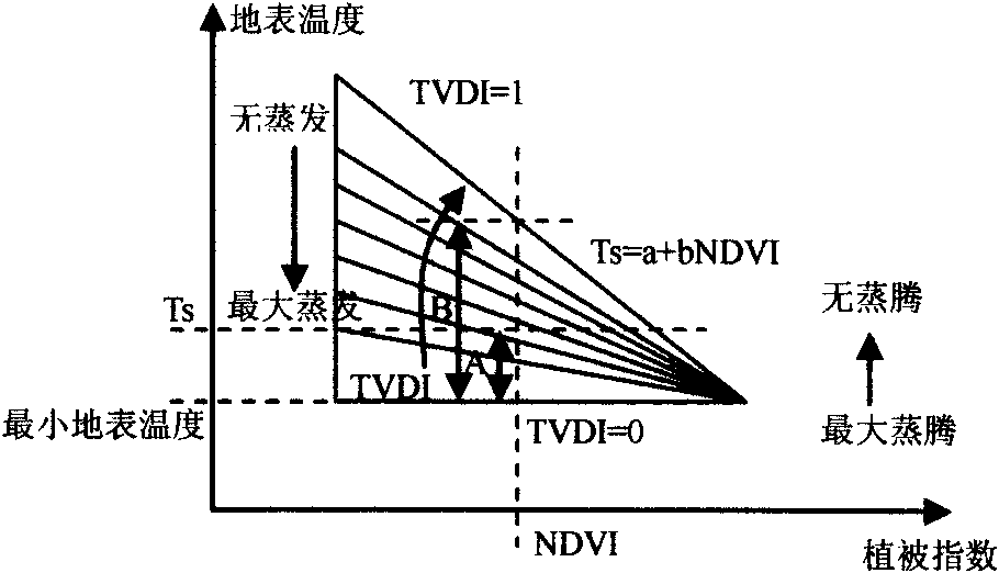
[0071] 1 Linear decomposition model based on NDVI and TVDI

[0072] 1.1 NDVI and land surface temperature

[0073] Landsat TM 6th band (10.4-12.5 μm) is used to calculate the surface temperature, where TM refers to the multi-band scanning images acquired by the US Landsat 4-5 Thematic Mapper. First, radiometric calibration is performed on the 3rd, 4th, and 6th bands of the TM image, and the DN value is converted into the corresponding apparent radiance (DN refers to the gray value of the image). Using the radiation correction equation (2) provided in the Landsat user manual:

[0074] L λ = L max λ - L min λ ...


PUM


Abstract

The invention discloses a method for estimating coverage based on NDVI and vegetation-soil moisture response of NDVI to TVDI response sensibility. The vegetation coverage comprises bare land coverage fcb, grassland coverage fcg and forest and shrub blended coverage fcf / s, wherein the fcf / s comprises the forest coverage fcforest and the shrub coverage fcshrub. The method comprises the following steps: determining the values of vegetation indexes NDVI and TVDI of a normalized difference value of each pixel in a research zone; determining the value of alpha of the value of NDVI of each pixel in the research zone to TVDI sensitivity; constructing a triangular scatter diagram of the research zone based on the values of alpha and the NDVI of each pixel in the research zone; determining the values of alpha and NDVI of the end member of each endpoint of a triangle based on the triangular scatter diagram; and carrying out linear resolution on each pixel in the research zone to obtain fcb, fcg and fcf / s of each pixel in the research zone by using a least square method, according to the values of alpha and NDVI of each determined end member at each endpoint of the triangle and under the constraint condition that fcb is not less than 0 and is not greater than 1, fcg is not less than 0 and is not greater than 1 and fcf / s is not less than 0 and is not greater than 1.

Description

technical field [0001] The present invention generally relates to vegetation coverage, in particular to a method for estimating vegetation coverage based on the vegetation-soil moisture response relationship. Background technique [0002] The earlier models that used remote sensing data to estimate vegetation coverage were empirical models. One kind of empirical model is to establish a linear or nonlinear empirical relationship model by using the field measured vegetation coverage and remote sensing information, and then apply the model to the whole research area. This type of empirical model simply establishes a certain relationship between ground measured data and remote sensing data, and simply expands the ground measured data into the two-dimensional space of remote sensing information. The characteristic index (vegetation index) that can reflect the growth status and distribution of green vegetation formed due to the linear and nonlinear combination of reflectance spec...

Claims


Application Information

Patent Timeline
Patent Type & Authority Applications(China)
IPC IPC(8): G06Q50/00G06F19/00
Inventor 王宏李晓兵龙慧灵
Owner BEIJING NORMAL UNIVERSITY
Why Eureka
Try Eureka