Urban power network geographic information system and urban pipeline geographic information system

A technology of geographic information system and urban power grid, applied in the field of urban pipeline geographic information system and urban power grid geographic information system, can solve problems such as inaccuracy, topological relationship, failure to reflect internal information of cable wells or cable trenches, etc.

Inactive Publication Date: 2010-12-29
上海辅昊实业有限公司
View PDF3 Cites 30 Cited by
  • Summary
  • Abstract
  • Description
  • Claims
  • Application Information

AI Technical Summary

Problems solved by technology

[0003] However, there are a lot of problems in the traditional urban power grid geographic information system (referred to as urban power grid GIS system) and other urban pipeline geographic information systems, which cannot meet the management needs
[0004] Taking the urban power grid GIS system as an example, the main problem of the existing urban power grid GIS system is that the existing urban power grid GIS system has a small amount of information and does not show the topological relationship between the cable well and the cable corridor
The cable well in the existing urban power grid GIS system is just a label, which only tells the user where the cable well is roughly located. It does not establish a topological relationship between the cable and the cable trench, the cable well, etc., and cannot reflect the inside of the cable well or the cable trench. information
And the described position is also inaccurate, and there is no related description. When the user needs to go to a certain cable well for operation, the existing urban power grid GIS system cannot give the user beneficial help, and the user can only Rely on other information to determine the exact location of the cable well and find the cable well
Moreover, when users work in cable wells, they also cannot get any effective help from the existing urban power grid GIS system, and lack real and effective first-hand field data.
[0005] In addition, the existing urban grid GIS system does not manage the uniqueness and accuracy of cables
There is also no management of cable-related information in combination with cable listing

Method used


Image

  • Urban power network geographic information system and urban pipeline geographic information system
  • Urban power network geographic information system and urban pipeline geographic information system
  • Urban power network geographic information system and urban pipeline geographic information system

Examples


Embodiment Construction

[0025] Typical embodiments embodying the features and advantages of the present invention will be described in detail in the following description. It should be understood that the present invention is capable of various changes in different embodiments without departing from the scope of the present invention, and that the description and drawings therein are illustrative in nature and not limiting. this invention.

[0026] A city power grid geographic information system for urban power grid underground cable and trench resource management according to a preferred embodiment of the present invention will be described in detail below.

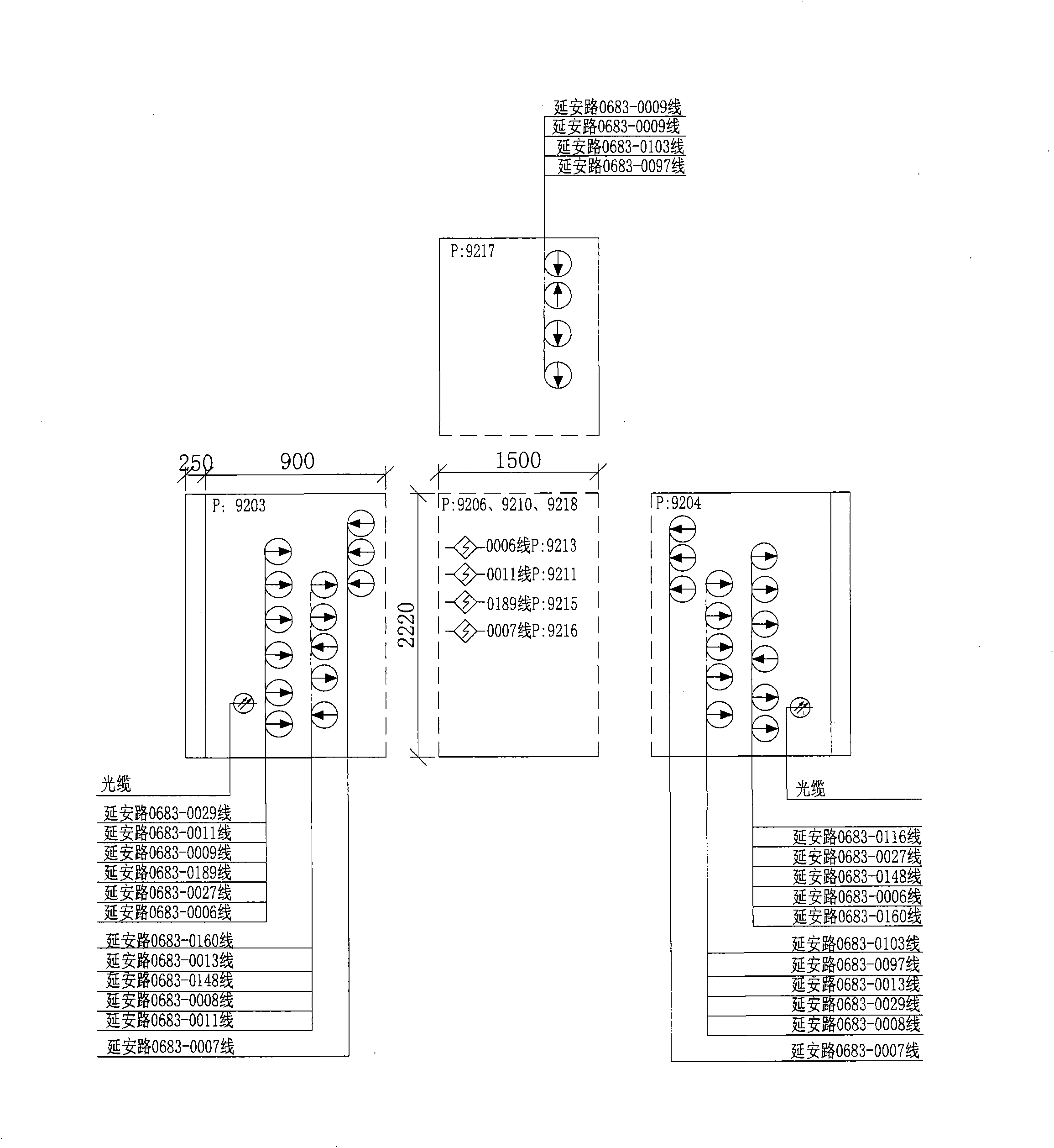
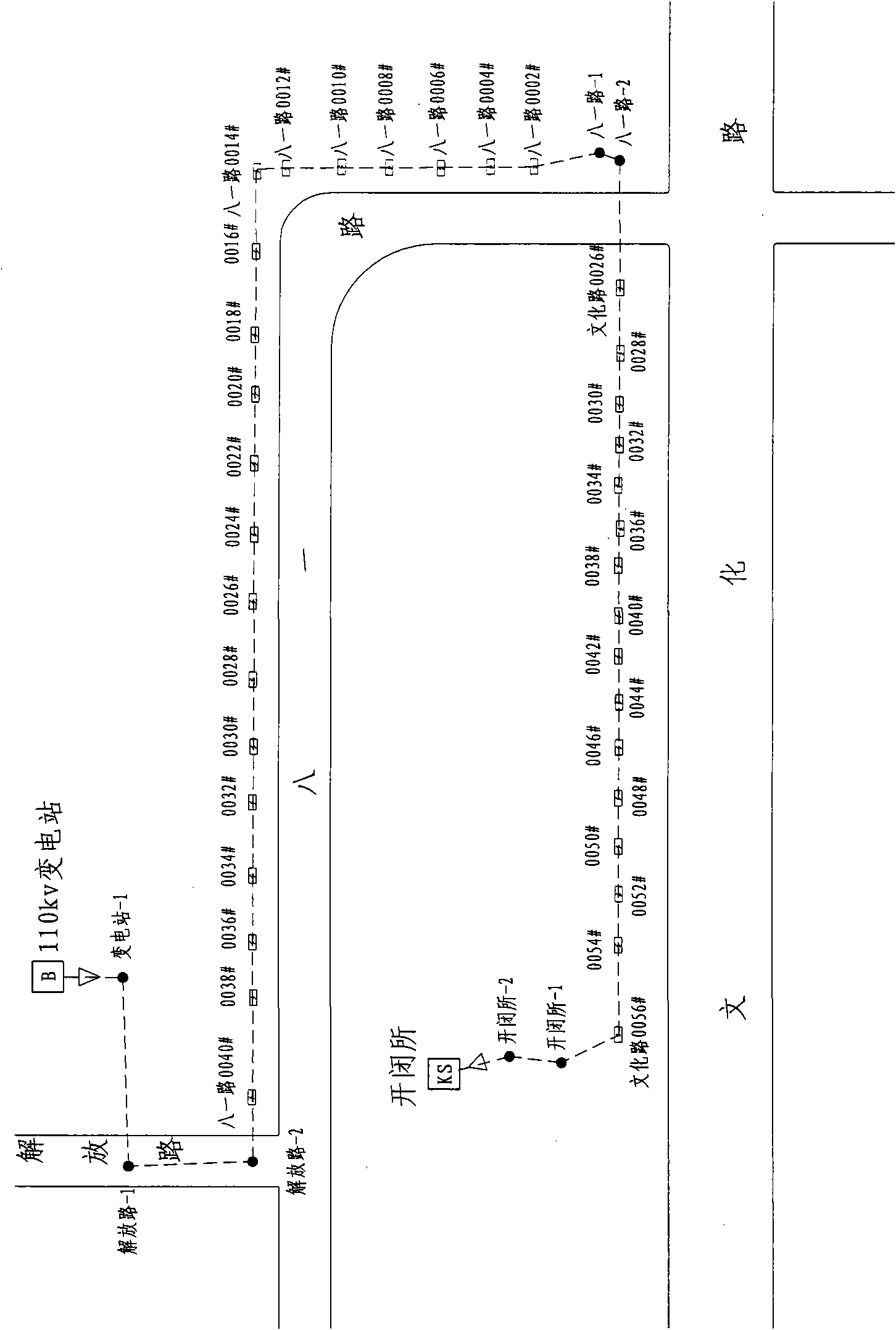
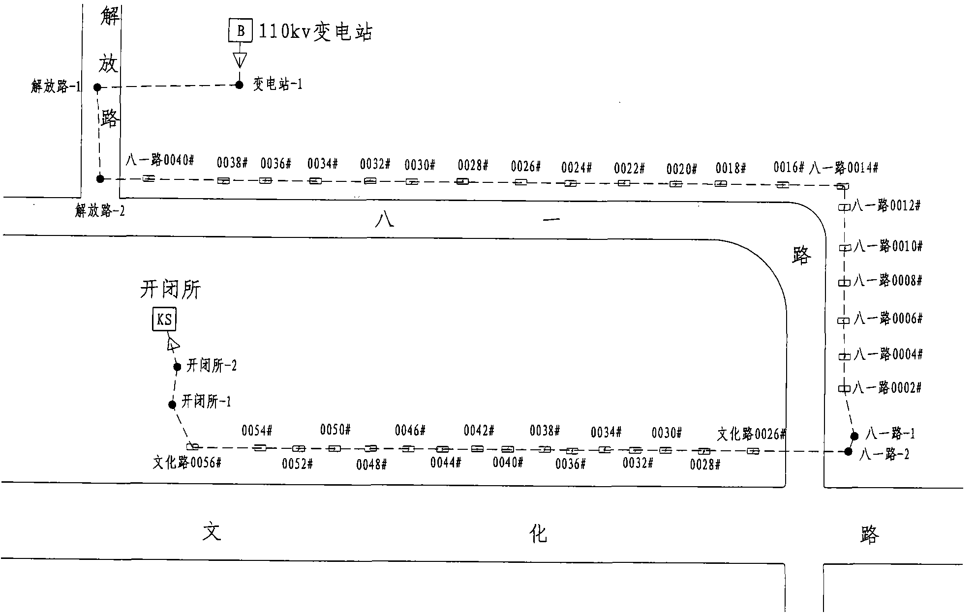
[0027] The geographical information system of the urban power grid of the present invention mainly includes five modules, namely an electronic map module, a database module, a directory tree module, a direction map module and a display module, wherein the electronic map module and the display module are respectively used to generate basic geogr...


PUM


Abstract

The invention discloses an urban power network geographic information system and an urban pipeline geographic information system, which are used for managing an urban power network and other pipeline underground resources. The urban power network geographic information system comprises an electronic map module, a database module, a directory tree module, an alignment map module and a display module, wherein the database module establishes and maintains a database which comprises cable information, cable well information, underground pipe drain resource information, equipment information and transformer substation information; the directory tree module establishes directory trees stage by stage by using a transformer substation as a unit; the alignment map module generates an alignment map which describes the cable direction on a basic geographic information layer according to the directory trees and is associated with profile charts on cable well identifiers and pipe drain identifiers in the alignment map; and the display module displays the alignment map of the cable. The geographic information systems of the urban power network and other pipelines intuitively show the topological relations of cables in cable wells and cables in cable passages for a user.

Description

technical field [0001] The invention relates to a geographical information system, in particular to a geographical information system of an urban power grid and a geographical information system of an urban pipeline. Background technique [0002] With the development of modern cities, urban power grids and other municipal pipelines or lines. Pipelines, such as tap water, gas and other pipelines; lines, such as communication cables, cable TV cables, etc., the following urban municipal pipelines and lines are collectively referred to as urban pipelines. Urban pipeline resources are becoming more and more abundant, and management is becoming more and more difficult. How to visually present the direction and extension of cable corridors (or other urban pipeline corridors), the relationship between cable wells (or other urban pipeline pipeline wells) and cables (pipelines) has become a new topic. [0003] However, there are many problems in the traditional urban power grid geog...

Claims


Application Information

Patent Timeline
Patent Type & Authority Applications(China)
IPC IPC(8): G06F17/30H02J4/00
Inventor 张霞芹
Owner 上海辅昊实业有限公司
Why Eureka
Try Eureka