Remote sensing image segmentation method based on region clustering

A technology of remote sensing images and regions, applied in image enhancement, image data processing, instruments, etc., can solve the problems of immaturity and image segmentation accuracy to be improved, achieve good adaptability and robustness, good image segmentation effect, and eliminate noise Effect

Inactive Publication Date: 2011-04-06
NANJING UNIV
View PDF5 Cites 49 Cited by
  • Summary
  • Abstract
  • Description
  • Claims
  • Application Information

AI Technical Summary

Problems solved by technology

This method has developed rapidly in recent years. Many new methods are more effective in segmenting specific images. Since there is no general theory, these methods have their own advantages and disadvantages. They are generally immature, and the accuracy of image segmentation still needs to be improved.

Method used


Image

  • Remote sensing image segmentation method based on region clustering
  • Remote sensing image segmentation method based on region clustering
  • Remote sensing image segmentation method based on region clustering

Examples


Embodiment

[0057] with attached Figure 4 The shown Xinyinggang remote sensing image is used as the remote sensing image to be segmented, and the image size is 500 rows*500 columns. The whole image segmentation process of this method is realized by using the standard C++ programming language. The read and write operations of remote sensing image data are implemented with the open source geographic data format conversion class library GDAL.

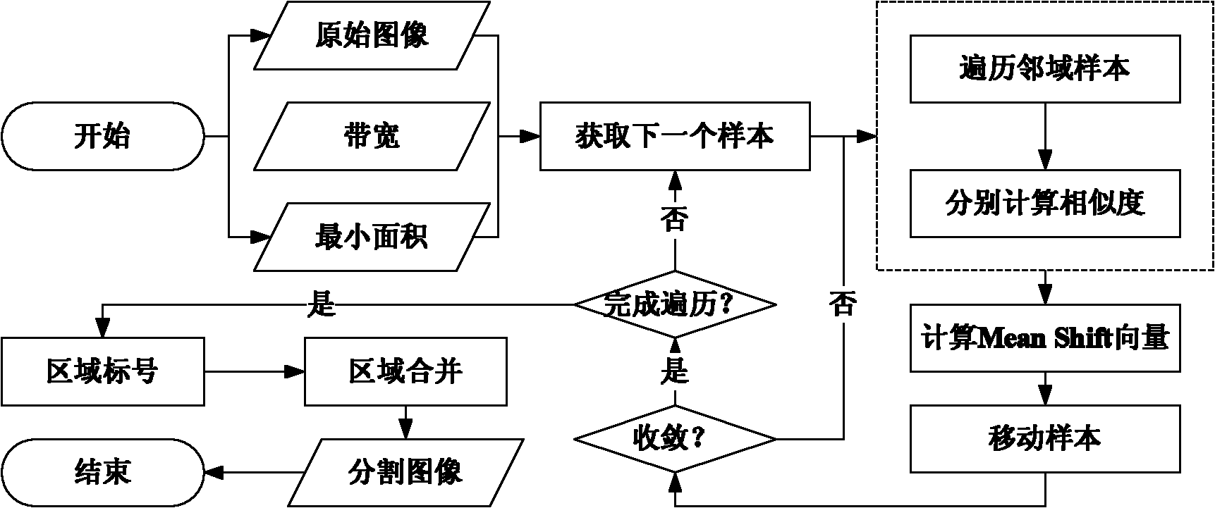
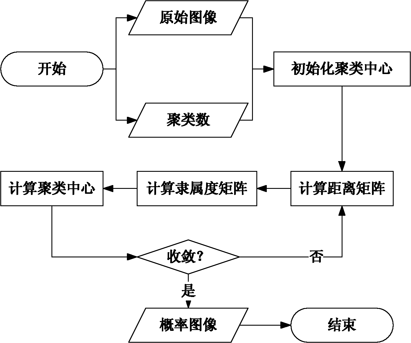
[0058] It mainly consists of four steps: region pre-segmentation; fuzzy clustering; region re-segmentation; merging of segmented objects.

[0059] Step 1: Region pre-segmentation. Purpose: one is to remove image noise, and the other is to realize the preliminary clustering of pixels. (The whole process is attached figure 2 shown in the flowchart)

[0060] 1) Read data.

[0061] Use GDAL as a data reading and writing tool, use the GDALOpen method to read remote sensing image files, and convert them into integer arrays with the size of 500 rows*...


PUM


Abstract

The invention discloses a remote sensing image segmentation method based on region clustering, belonging to the field of remote sensing image comprehensive utilization. The method comprises the following steps: carrying out region pre-segmentation by a MeanShift algorithm to remove noise and perform initial cluster on image elements; carrying out fuzzy clustering on images which are subject to the pre-segmentation by a fuzzy C-means algorithm (FCM), and initially inducing and identifying characteristics of each image object to obtain the probability that each object affiliates to some a category so as to constitute a land category probability space of the remote sensing images, thereby providing a basis of object combination for further region segmentation; and performing region segmentation in the probability space of clustering images, classifying image elements which are close in the probability space and similar in the category as the same objects by region labels. In the method of the invention, two defects in the existing segmentation method are overcome, the remote sensing images can be effectively and accurately segmented, segmentation tasks of the remote sensing images can be finished by batch by integration, and data support can be preferably provided for extraction of land information from the remote sensing images.

Description

technical field [0001] The invention relates to a remote sensing image segmentation method, in particular to a remote sensing image segmentation method that uses a fuzzy C-means (Fuzzy CMeans, FCM) algorithm for fuzzy clustering and a mean shift (Mean Shift) algorithm for region segmentation. Background technique [0002] Remote sensing image segmentation refers to the process of dividing the pixels in the remote sensing image into several specific regions that do not intersect each other. The use of remote sensing image segmentation technology in the automatic extraction of typical coastal zone remote sensing information has three meanings: first, the processed object has transitioned from a pixel to an object corresponding to the real world map spot, which is closer to the human observation data. Thinking logic; secondly, make different pixels in the same object have the same spectral characteristics, to a certain extent overcome the problem of different spectra of the sam...

Claims


Application Information

Patent Timeline
Patent Type & Authority Applications(China)
IPC IPC(8): G06T5/00
Inventor 李满春程亮刘永学黄秋昊江冲亚赵威陈焱明杨康
Owner NANJING UNIV
Why Eureka
Try Eureka