Super-high-rise building verticality measuring and controlling method based on GPS (Global Positioning System)

A measurement and control method and building technology, applied in the direction of measuring devices, measuring instruments, surveying and navigation, etc., can solve the problems of error amplification and other problems, achieve the effect of simple operation steps, eliminate accumulated errors, and improve verticality

Active Publication Date: 2011-06-01
SHANGHAI CONSTR NO 1 GRP
View PDF3 Cites 24 Cited by
  • Summary
  • Abstract
  • Description
  • Claims
  • Application Information

AI Technical Summary

Problems solved by technology

However, due to the limitation of the observation height of the zenith method, it is necessary to convert the datum point, which inevitably produces cumu

Method used


Image

  • Super-high-rise building verticality measuring and controlling method based on GPS (Global Positioning System)
  • Super-high-rise building verticality measuring and controlling method based on GPS (Global Positioning System)
  • Super-high-rise building verticality measuring and controlling method based on GPS (Global Positioning System)

Examples


Embodiment Construction

[0010] The present invention will be further described below in conjunction with the accompanying drawings and embodiments.

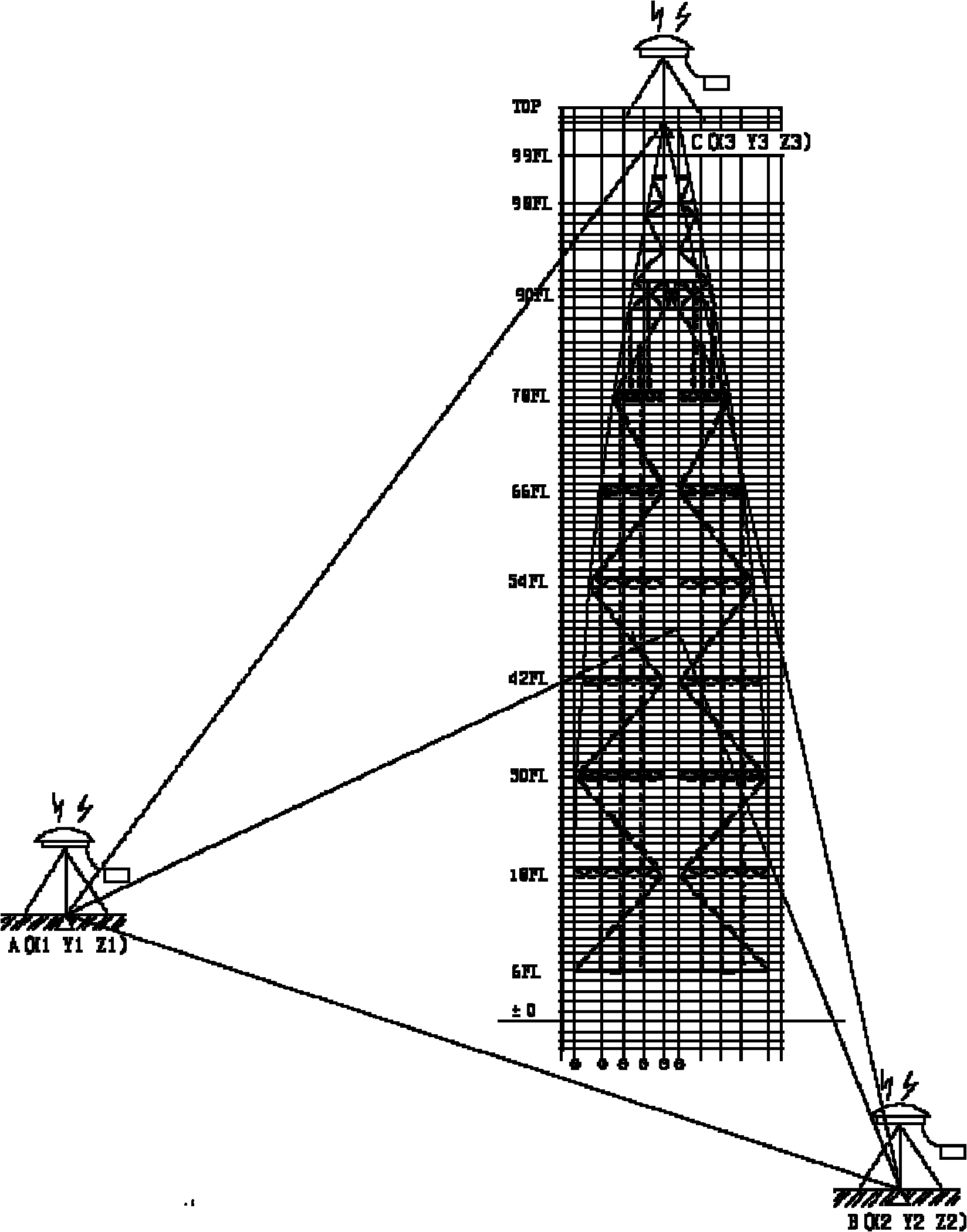
[0011] For example, in a specific construction project, the height of the floor structure reaches 632 meters. If the traditional method is used, it will not only accumulate the cumulative error exceeding the limit, but also superimpose the vertical deformation of the structure itself, and the error will be exacerbated and magnified. Secondly, due to the huge demand for the number of control points in the construction of the core tube, and the time reserved for measurement and setting-out is quite tight.

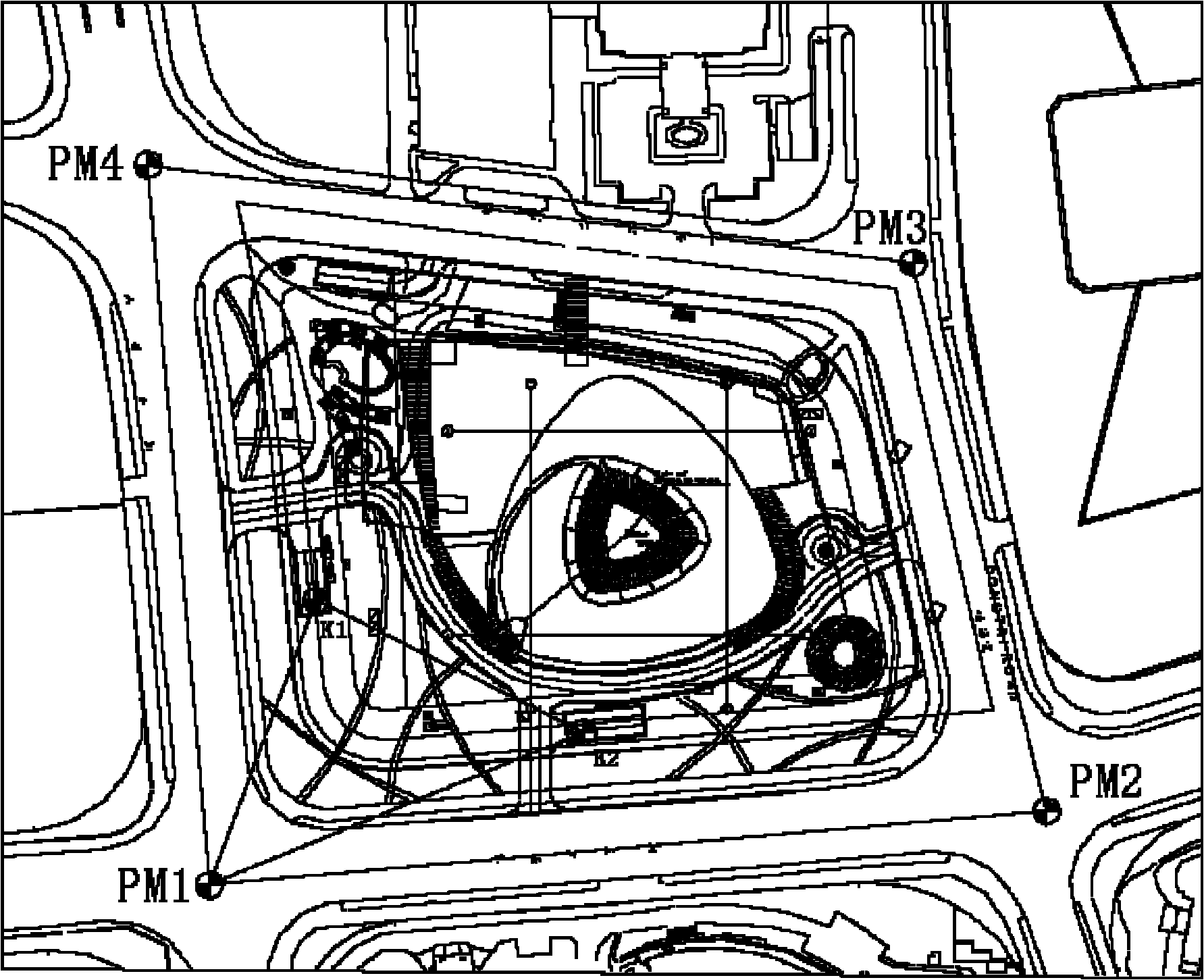
[0012] The GPS-based verticality measurement and control method of the super high-rise building of the present invention is used for measurement, and a high-precision GPS static measurement mode is adopted. figure 1 For the layout of the ground reference control network, place two of the GPS reference stations on any two points in PM1-PM4. A mobile st...


PUM


Abstract

The invention discloses a super-high-rise building verticality measuring and controlling method based on a GPS (Global Positioning System). A high-accuracy GPS static measurement mode is adopted, two base stations are placed on a base control network point on the ground, one mobile station is placed on any position of a construction floor surface, a first floor measurement control point is obtained through timing observation, a second floor measurement control point is obtained by using the same method, one of the two control points is used as a station measuring point and the other is used as a rear view point for checking a measuring point, and a floor axis control point is set out after no errors exist. By adopting the invention, accumulated errors in the traditional method can be eliminated, and the verticality of the building structure is improved. In addition, because each measurement is started from a base control network on the ground, no accumulated errors exist, and the maximum error source of the super-high-rise floor verticality control is eliminated.

Description

technical field [0001] The invention belongs to the technical field of construction engineering, in particular to a method for measuring and controlling the verticality of a super high-rise building, in particular to a method for measuring and controlling the verticality of a super high-rise building based on GPS. Background technique [0002] During the construction of a super high-rise building, due to the structural height of the main building, it becomes a measurement problem to provide accurate positioning points for the upper structure of the main building of a high-rise building. The current traditional floor measurement method is the "zenith method", that is, the zenith instrument is used to pass the positioning point of the lower floor through the floor to the construction floor through the reserved hole. However, due to the limitation of the observation height of the zenith method, it is necessary to convert the datum point, which inevitably produces cumulative err...

Claims


Application Information

Patent Timeline
IPC IPC(8): G01C15/00G01C15/02G01C15/12
Inventor 施志远朱毅敏徐峰朱成捷陈康徐磊
Owner SHANGHAI CONSTR NO 1 GRP
Why Eureka
Try Eureka