Road matching method based on GIS (Geographic Information System)

A matching method and road technology, applied in directions such as road network navigators, can solve the problems of slow matching speed, unsuitable for navigation equipment, high algorithm time complexity, and achieve the effect of accurate and precise matching.

Inactive Publication Date: 2011-08-17
FUJIAN ZHONGGENG SHITONG INFORMATION TECH CO LTD
View PDF5 Cites 18 Cited by
  • Summary
  • Abstract
  • Description
  • Claims
  • Application Information

AI Technical Summary

Problems solved by technology

If you want to obtain higher matching accuracy, you need to use the Kalman filter for more accurate correction processing for each GPS point, so a large amount of data processing is required, and the time complexity of the algorithm is high, and the matching speed is slow. The efficiency is not high, it is difficult to reach a practical level, and it is not suitable for use on ordinary navigation equipment

Method used


Image

  • Road matching method based on GIS (Geographic Information System)
  • Road matching method based on GIS (Geographic Information System)

Examples


Embodiment Construction

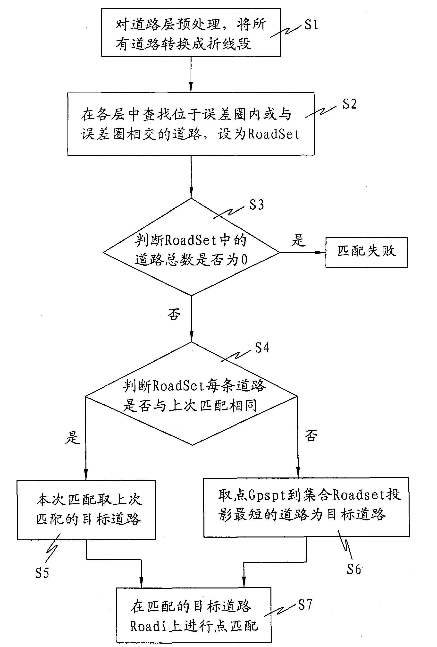
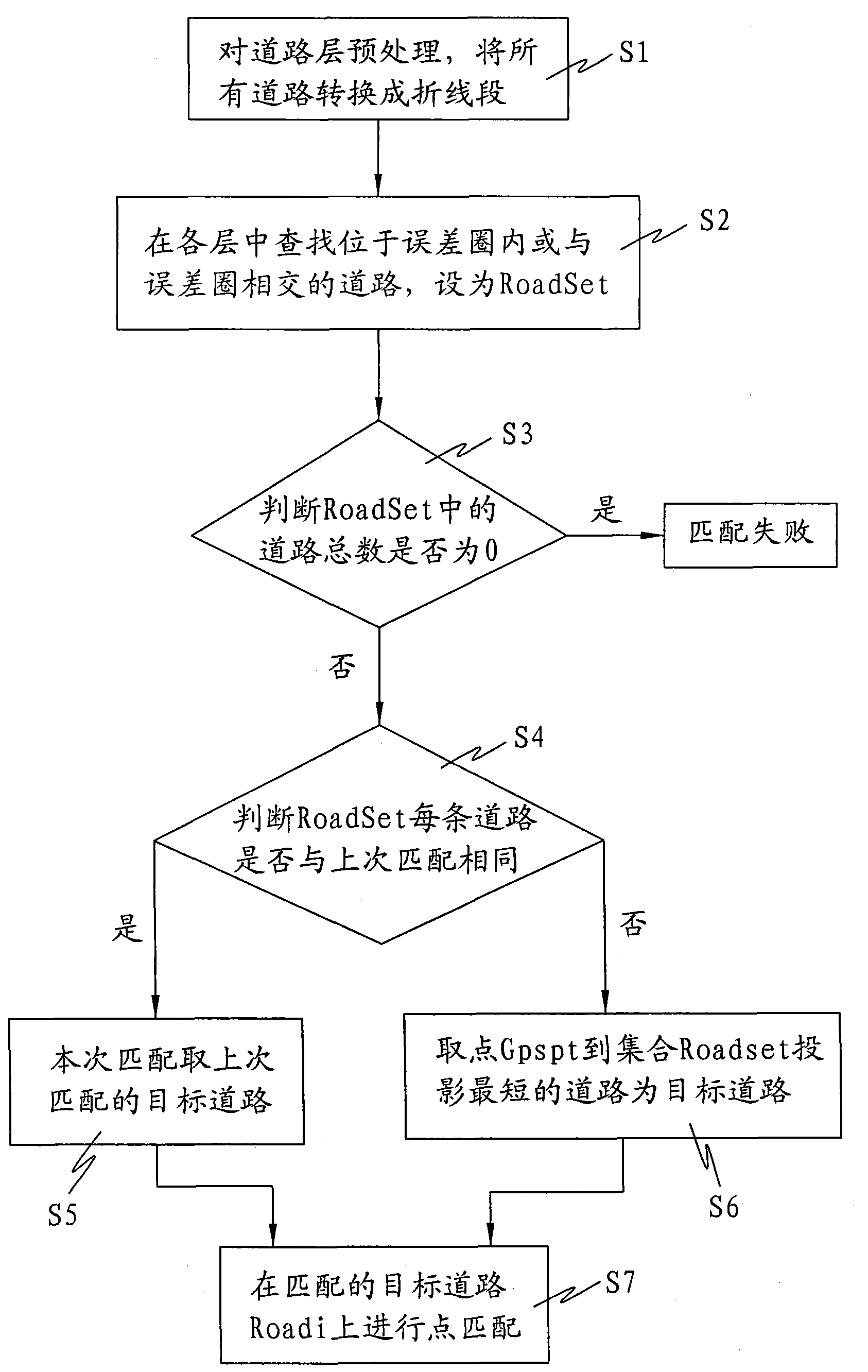
[0025] A flow chart of a preferred embodiment of the present invention will be further described below.

[0026] A flowchart of a preferred embodiment of a GIS-based road matching method of the present invention. refer to figure 1 ,Specifically:

[0027] Step S1: Preprocessing the road layer on the GIS electronic map, converting all roads into a data set connected by a series of related polyline segments;

[0028] Step S2: Find roads located within or intersecting the error circle in each layer of the road layer;

[0029] The specific process includes:

[0030] Step S2a: taking the original latitude and longitude coordinates collected by GPS corresponding to the point GPSpt on the GIS electronic map as the center of the circle, and making a circle with the maximum positioning error as the radius;

[0031] Step S2b: The roads within the circle or intersecting with the circle form a road set, which is defined as RoadSet;

[0032] Step S3: Determine the total number of roads...


PUM


Abstract

The invention discloses a road matching method based on a GIS (Geographic Information System), which is used for dynamical positioning and dispatching. The method comprises the steps of carrying out a road matching algorithm on a point GPS (Global Position System) pt corresponding to latitude and longitude coordinates collected by a GPS terminal on a GIS electronic map; pre-processing a road layer of the GIS electronic map and converting all roads into broken line sections; looking up a road positioned within an error cycle or intersected with the error cycle in each layer, setting the road as a RoadSet; matching unsuccessfully if the RoadSet is 0; taking a previously matched target road while the road name of a Roadi is as same as a previously matched road name, and otherwise, using a road having a shortest projection distance from the point GPS pt to each road in a road set as a matched target road; and carrying out point matching on the matched target road Roadi. By using the invention, a running route of a vehicle is accurately matched with the road of the GIS electronic map, problems of low road matching speed and inaccurate matching in the prior art are solved, and the road matching efficiency is increased.

Description

technical field [0001] The invention relates to the field of dynamic positioning intelligent navigation based on a GIS geographic information system, in particular to a GIS-based road matching method. Background technique [0002] GIS (Geographic Information System), which began to appear in the late 1950s and early 1960s, is a technical system for comprehensively processing and analyzing geospatial data. GIS geographic information system is based on geospatial database, with the support of computer software and hardware, using the theory of system engineering and information science, scientifically manages and comprehensively analyzes geographic data with spatial connotation, so as to provide information required for management and decision-making. technology system. [0003] Because there are certain errors in the latitude and longitude coordinates of the vehicle trajectory collected by the vehicle GPS and the road on the GIS electronic map, in order to correct and reduce...

Claims


Application Information

Patent Timeline
Patent Type & Authority Applications(China)
IPC IPC(8): G01C21/30
Inventor 柳琴华陈祥耀
Owner FUJIAN ZHONGGENG SHITONG INFORMATION TECH CO LTD
Why Eureka
Try Eureka