Method for constructing three-dimensional physical model of sedimentary stratum system by using drilling data

A technology of borehole data and three-dimensional entities, which is applied in the field of constructing three-dimensional entity models of sedimentary strata systems using borehole data, and can solve the problems of increasing the complexity of stratigraphic layer interpolation and fitting, lack of reasonable perfection, and cumbersomeness.

Inactive Publication Date: 2011-11-23
EAST CHINA NORMAL UNIV
View PDF1 Cites 42 Cited by
  • Summary
  • Abstract
  • Description
  • Claims
  • Application Information

AI Technical Summary

Problems solved by technology

However, there is still a lack of simple, general, efficient and automatic modeling methods for complex sedimentary stratigraphic systems
Existing modeling methods have more or less defects. One of the most prominent problems is that these methods lack a reasonable and complete missing strata processing mechanism, resulting in a large difference between the computer modeling results and the actual stratum distribution. Reflecting the spatial distribution characteristics of missing strata
The discontinuity of the geological interface caused by missing strata will increase the complexity of stratigraphic interpolation and fitting
Although the missing stratigraphic interface control information can be added to the modeling process by adding virtual boreholes or geological sections, but in the actual implementation process, manually adding virtual boreholes or geological sections is very subjective, and at the same time It is also an extremely tedious work, not suitable for automatic or semi-automatic modeling by computer

Method used


Image

  • Method for constructing three-dimensional physical model of sedimentary stratum system by using drilling data
  • Method for constructing three-dimensional physical model of sedimentary stratum system by using drilling data
  • Method for constructing three-dimensional physical model of sedimentary stratum system by using drilling data

Examples


Embodiment Construction

[0074] Below in conjunction with accompanying drawing and specific embodiment the present invention will be described in further detail:

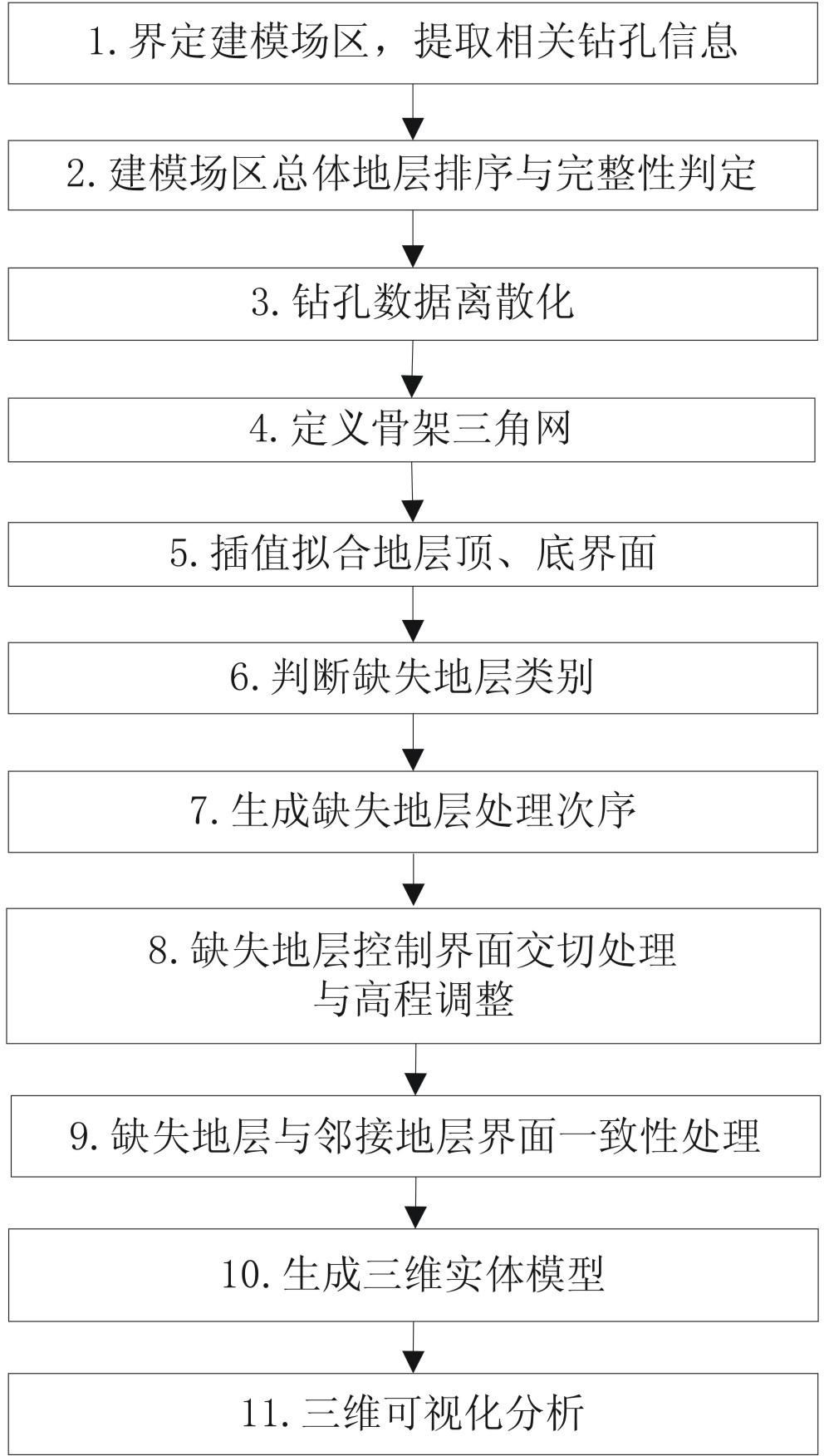
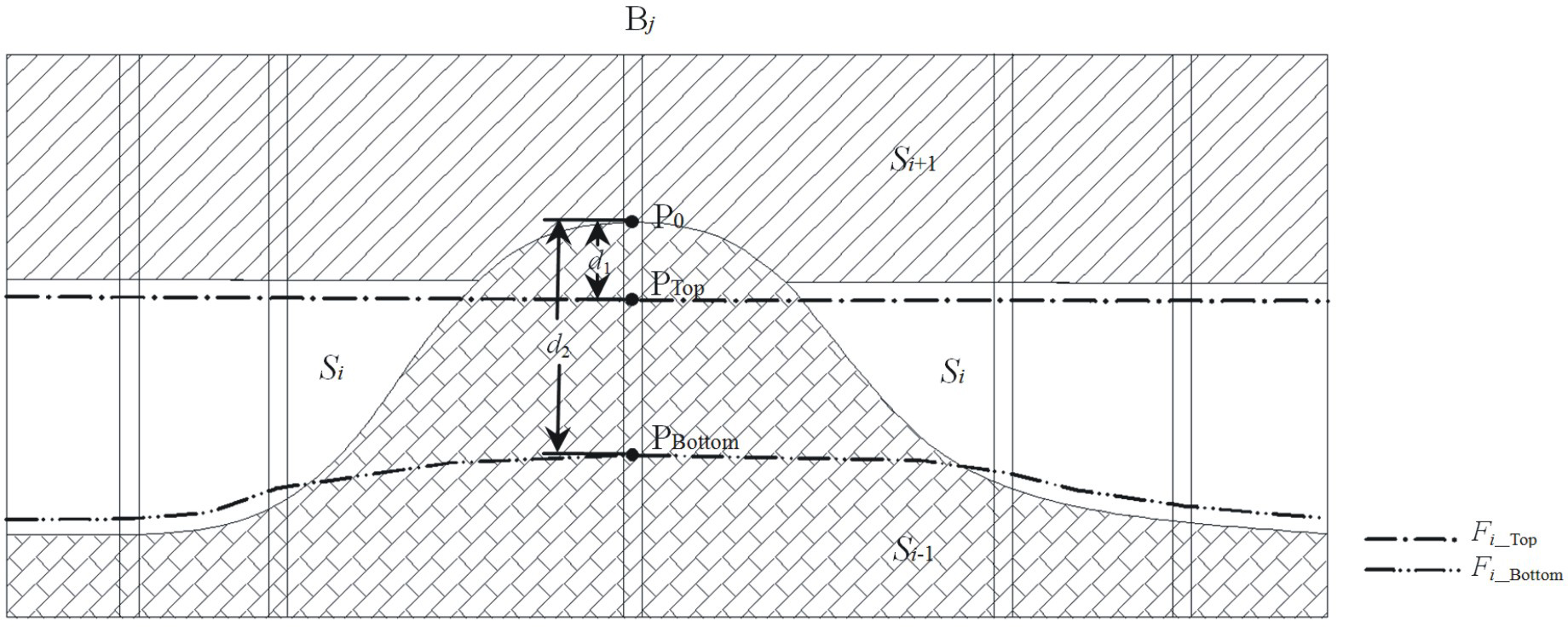
[0075] refer to figure 1 As shown, the present invention discretizes the borehole data into a series of scatter points by using the binary topology structure, and based on these scatter points interpolation fits the initial elevation of the top and bottom interfaces of each stratum; According to the initial elevation of the bottom interface at each drilling position, the geological origin and category of the missing strata are automatically calculated; the processing sequence of the missing stratum is automatically generated according to the formation sequence and the fault relationship of the missing stratum; according to the category and geological origin of the missing stratum Automatically perform intersection processing and elevation adjustment of missing strata control interfaces. The present invention can adopt Microsoft Visual C ++ ...


PUM


Abstract

The invention discloses a method for constructing a three-dimensional physical model of a sedimentary stratum system by using drilling data, which is used for processing stratum surface data detected through geological drilling and solving various problems encountered during discontinuous stratum surface data encryption interpolation reconstruction in the sedimentary stratum system and belongs to the technical application field of three-dimensional geological simulation in engineering science and technology. The method comprises the following steps of: defining a modeling field and extracting relevant drilling information; judging modeling field total stratum ordering and integrity; discretizing drilling data; defining a skeleton triangulation network; interpolating and fitting a stratum top and bottom interface; judging the lost stratum category; generating a lost stratum processing sequence; carrying out lost stratum control interface intersected processing and elevation adjustment; carrying out lost stratum and adjacent stratum interface consistency processing; generating a three-dimensional physical model; and carrying out three-dimensional visual analysis. Compared with the traditional method, the method provided by the invention can be used for automatically judging the geologic origin of the lost stratum and defining the lost boundary and has the advantages of high automaticity and strong adaptability. A reasonable modeling result and high model precision are obtained, and the generated stratum lost boundary is natural and reasonable and is quite close to a practical stratum distribution condition.

Description

technical field [0001] The present invention relates to the application field of three-dimensional geoscience simulation technology in engineering science and technology, specifically a method for automatically constructing a three-dimensional solid model of a sedimentary stratum system using engineering drilling data. Processing can solve various difficulties encountered in the interpolation and reconstruction of discontinuous stratigraphic data in the sedimentary stratigraphic system. Background technique [0002] The 3D modeling and visualization of geological bodies is a research and application hotspot in the field of geoinformation science. The 3D geological solid model constructed based on 3D geoscientific simulation technology can intuitively and vividly display the boundary conditions of complex geological phenomena and various geological structures inside the geological body, enhancing the intuitiveness and accuracy of geological analysis. The 3D geological solid ...

Claims


Application Information

Patent Timeline
Patent Type & Authority Applications(China)
IPC IPC(8): G06T17/05
Inventor 朱良峰孙建中李明江张成娟潘信
Owner EAST CHINA NORMAL UNIV
Why Eureka
Try Eureka