Irregular-size space-variant grid tomography imaging statics correction method

An irregular, grid layer technology, applied in the field of geophysical exploration, can solve the problems of limiting the authenticity and rationality of the tomographic inversion model, and the inability to accurately describe the boundary position of the geological body or the velocity body, so as to improve the forward and inversion Accuracy and effect of statics

Active Publication Date: 2012-02-01
BC P INC CHINA NAT PETROLEUM CORP +1
View PDF6 Cites 13 Cited by
  • Summary
  • Abstract
  • Description
  • Claims
  • Application Information

AI Technical Summary

Problems solved by technology

This condition limits the authenticity and rationality of the tomographic inversion model
Especially when there are undulations on the interface between the surface and the subsurface or pinch-outs in the stra

Method used


Image

  • Irregular-size space-variant grid tomography imaging statics correction method
  • Irregular-size space-variant grid tomography imaging statics correction method
  • Irregular-size space-variant grid tomography imaging statics correction method

Examples


Embodiment Construction

[0031] Examples are described in detail below in conjunction with the accompanying drawings.

[0032] The present invention adopts following steps to realize:

[0033] 1. Model mesh division:

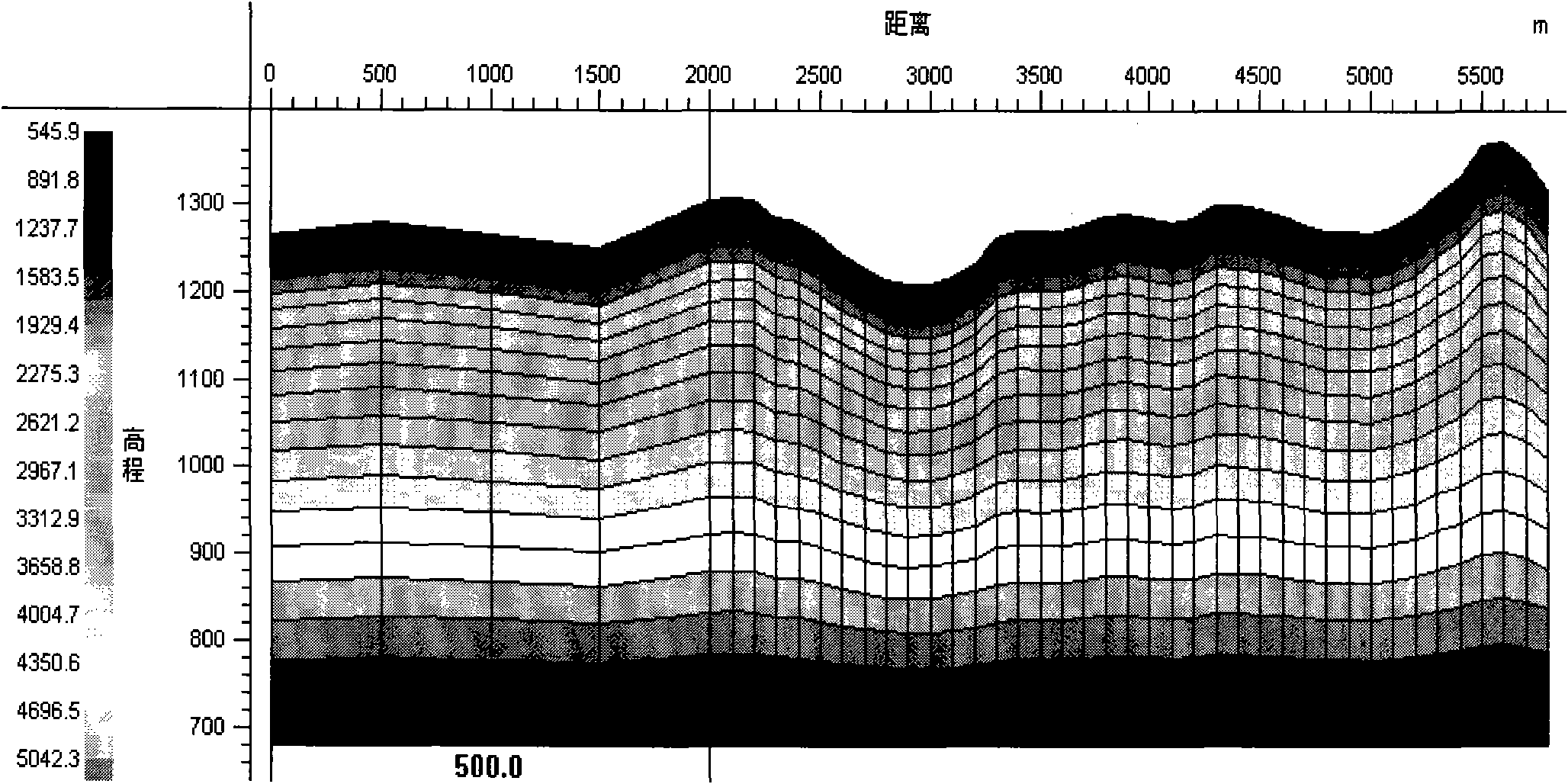
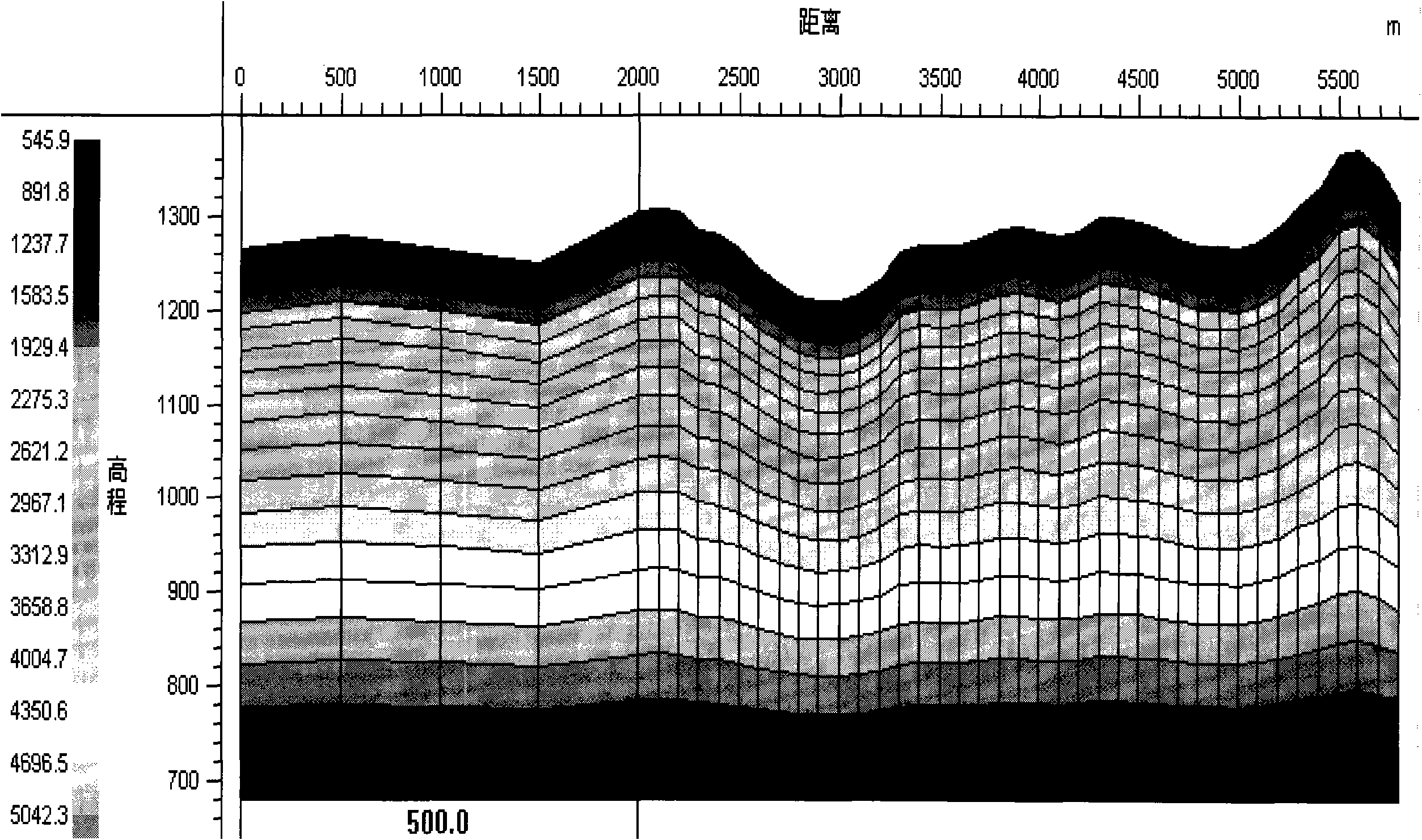
[0034] After data sampling, the coordinate range of all receiving points and excitation points determines the length of the model, and divides them at unequal intervals in the horizontal direction; for example figure 2 As shown, the track spacing is 100 meters, on the left side of the model, the grid spacing in the horizontal direction is 500 meters, and in the middle of the model, the grid spacing is 100 meters. In the vertical direction, determine a ground surface with the elevations of the receiving point and the excitation point, and ensure that the elevations of all receiving points and excitation points are below the ground surface. Given the elevation of the bottom surface of the model and the number of grids in the vertical direction, linearly interpolate the elevation values...


PUM


Abstract

The invention discloses an irregular-size space-variant grid tomography imaging statics correction method in geophysical exploration. The method is characterized by: arranging different grid lengths along a horizontal direction during performing mesh generation; arranging novel nodes on four sides of the grid; performing equal layout on a same distance in a horizontal direction or a vertical direction; or carrying out the equal layout of the nodes on the each grid side in the horizontal direction or the vertical direction; initializing a model speed and performing ray path forward modeling; calculating a difference value between actual picked first break time and ray travelling time and the speed of an inversion model; completing imaging statics correction till inversion speed field is stable. By using the method of the invention, a near surface characteristic of an actual stratum can be better described; propagation rules of a first break wave on the near surface can be better reflected; forward and inversion precision of the speed model can be raised and a statics correction effect can be raised too.

Description

technical field [0001] The invention relates to a geophysical exploration method, which is a static correction method for space-variable grid tomographic imaging with irregular dimensions. Background technique [0002] Static correction processing in seismic exploration is mainly to solve the problem that the travel time change of seismic waves in the near-surface medium affects the reflection wave stacking imaging problem. The first arrival wave reflects the change of the near-surface strata, and using the first arrival wave to obtain the static correction value has become the main technical means of static correction. Tomographic forward and inversion methods can be used to establish relatively accurate near-surface models that can reflect vertical and horizontal velocity changes. In recent years, tomographic methods have been widely used in production and have achieved good results in many complex areas. [0003] Conventional tomographic methods currently used in static ...

Claims


Application Information

Patent Timeline
IPC IPC(8): G01V1/36
Inventor 李培明冯泽元闫智慧马青坡
Owner BC P INC CHINA NAT PETROLEUM CORP
Why Eureka
Try Eureka