Data grading organization method based on longitude and latitude grid

A data classification and grid technology, applied in the field of remote sensing imaging, can solve the problems of loss of precision, large image deformation, large amount of data, etc., and achieve the effects of convenient organization and management, accurate assignment, and simple algorithm

Active Publication Date: 2013-10-23
AEROSPACE INFORMATION RES INST CAS
View PDF3 Cites 4 Cited by
  • Summary
  • Abstract
  • Description
  • Claims
  • Application Information

AI Technical Summary

Problems solved by technology

The shortcomings of the original MODIS data storage method are more obvious when the image data is mapped onto the 3D sphere
The first disadvantage is that directly pasting the entire MODIS image on the three-dimensional sphere requires a large amount of data, which is not conducive to hierarchical display and remote transmission
The second disadvantage is that when the entire image is mapped onto a sphere, generally only the four corners of the image are used as reference points, so the image is deformed greatly
In addition, complex floating-point operations will also cause problems when performing spherical texture mapping. The essence of texture mapping is the resampling of raster image data, and raster image data is stored in integer row and column numbers.
When the spherical latitude and longitude coordinates are represented by floating-point data, the floating-point coordinates must be transformed into grid coordinates, and there must be a loss of precision in this process
When the floating-point data is complex, precision loss may occur during the conversion process, resulting in inaccurate texture mapping
In addition, the digital image corresponding to the block mode of world wind cannot be well matched with the commonly used scales, and the 15-level mode of world wind cannot fully cover the commonly used scales, and scale conversion is required before it can be used for cartography production

Method used


Image

  • Data grading organization method based on longitude and latitude grid
  • Data grading organization method based on longitude and latitude grid
  • Data grading organization method based on longitude and latitude grid

Examples


Embodiment Construction

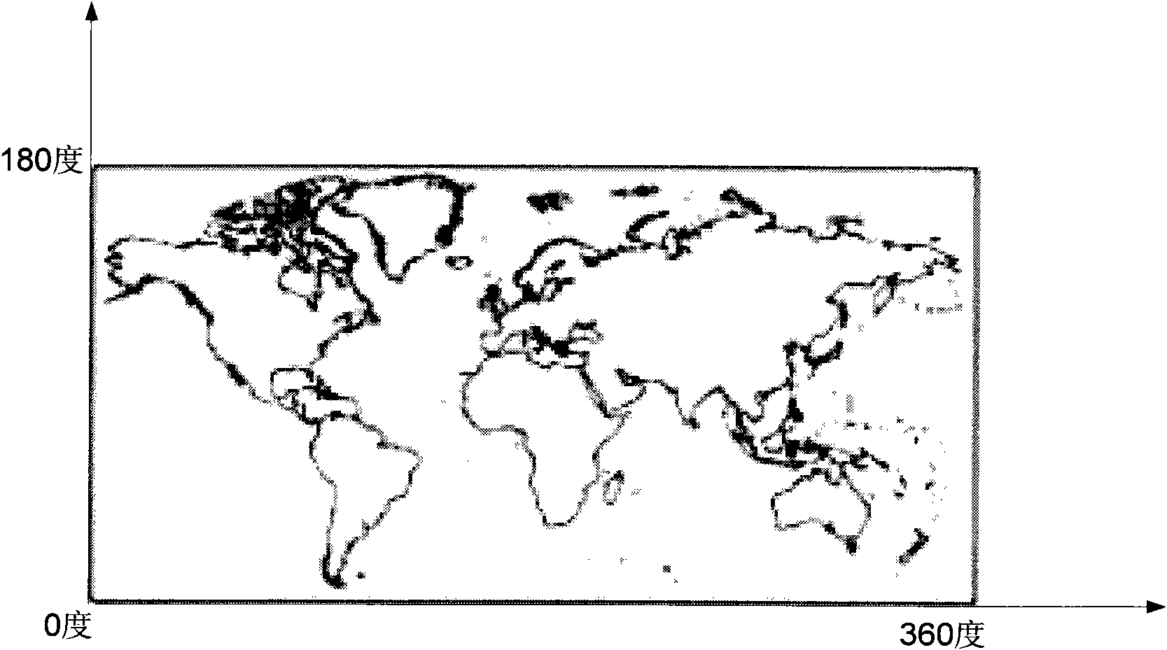
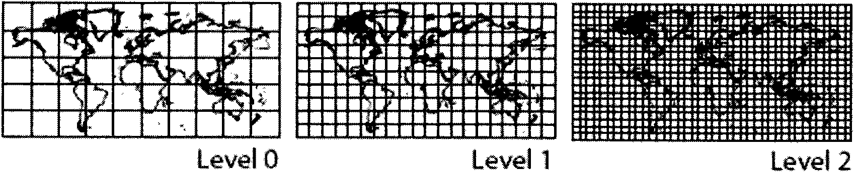
[0030] The data hierarchical organization method based on latitude and longitude grids of the present invention adopts a 5-layer 15-level block, and each block corresponds to a 1000×1000 image, wherein each layer has three levels, and the levels in the layer are according to 5:2.5 : The size ratio of 1 is arranged in order, and the difference between the layer and the adjacent layer is 10 times. The block size of the first layer is 50°×50°, 25°×25°, 10°×10°, and the second layer is 5° ×5°, 2.5°×2.5°, 1°×1°, and so on for other layers, block such as Figure 3a , 3b and 3c. Compared with World Wind, the present invention does not require such figure 1Projected as shown. And different from the method of World Wind that each block corresponds to a 512*512 image, each block in the present invention corresponds to a 1000*1000 image. The advantage of this segmentation method is that the size of the blocks at each level is a simple finite floating-point number, and the position ca...


PUM


Abstract

The invention discloses a data grading organization method based on longitude and latitude grid. The method comprises the following steps: carrying out 5 layers 15 grades partitioning on an Earth surface according to latitude and longitude, wherein each block is corresponding to an image of 1000 elements*1000 elements, each layer has three grades, the grades in the layer are arranged in order according to a size proportion of 5:2.5:1, difference between a layer with an adjacent layer is 10 times, block sizes in the first layer are 50 degrees*50 degrees, 25 degrees*25 degrees and 10 degrees*10 degrees in order, block sizes in the second layer are 5 degrees*5 degrees, 2.5 degrees*2.5 degrees, and 1 degree*1 degree in order, and so on. According to the data grading organization method based on longitude and latitude grid, a 5 layers 15 grades partitioning mode is carried out on the Earth surface, a size of each block of each grade is simple limited floating-point number, position determination is carried out according to a simplified latitude and longitude coordinate, organization and management of data are facilitated, when a plurality of blocks of pictures are displayed on a spherical surface, seamless splicing can be ensured, a grading partitioning mode of the present invention matches with a map scale well, and map output requirements of different scales are satisfied.

Description

technical field [0001] The invention relates to the field of remote sensing imaging, in particular to a data hierarchical organization method based on latitude and longitude grids. Background technique [0002] The images collected by the currently launched sensors are all in units of pixels, and each pixel stores the radiation information of the ground, and does not store the geometric information of the ground objects corresponding to the pixels. In order to calculate the geometric information of pixels, it is necessary to construct imaging equations, such as collinear equations corresponding to aerial remote sensing images. The geometric calculation method of space remote sensing is more complicated, and it is necessary to obtain the optical parameters of the satellite and the orbital parameters of the satellite during operation in advance, such as the widely used MODIS satellite, environmental satellite, and aerial remote sensing data. [0003] Taking MODIS data as an e...

Claims


Application Information

Patent Timeline
Patent Type & Authority Patents(China)
IPC IPC(8): G06T17/00G01S17/89
Inventor 顾行发余涛谢东海郭红胡新礼李家国程天海
Owner AEROSPACE INFORMATION RES INST CAS
Why Eureka
Try Eureka