Method for constructing three-dimensional terrain vector model based on multi-beam sonar submarine measurement data

A technology for measuring data and 3D terrain, used in 3D modeling, image data processing, instruments, etc.

Active Publication Date: 2012-05-09
HARBIN ENG UNIV
View PDF6 Cites 53 Cited by
  • Summary
  • Abstract
  • Description
  • Claims
  • Application Information

AI Technical Summary

Problems solved by technology

[0005] The purpose of the present invention is to provide a method for constructing a three-dimensional terrain vector model based on multi-beam sonar seabed measurement data,

Method used


Image

  • Method for constructing three-dimensional terrain vector model based on multi-beam sonar submarine measurement data
  • Method for constructing three-dimensional terrain vector model based on multi-beam sonar submarine measurement data
  • Method for constructing three-dimensional terrain vector model based on multi-beam sonar submarine measurement data

Examples


specific Embodiment approach 1

[0028] Combine below Figure 1 to Figure 8 This embodiment will be specifically described. This implementation mode includes the following steps:

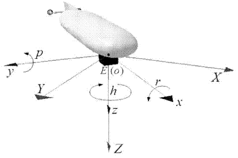
[0029] 1. Use unmanned autonomous underwater vehicles to use multi-beam sonar to collect the horizontal coordinates of the sampling points of the topography of the seabed area and the corresponding elevation data, as multi-beam sonar topographic measurement data points;

[0030] 2. Construct a Delaunay triangulation; the specific process is as follows: arrange all multi-beam sonar topographic survey data points according to the abscissa X and ordinate Y of the horizontal geographic coordinates; connect the two points p with the smallest abscissa X value 1 and p 2 , and take the direction of the point with the larger y-coordinate value pointing to the point with the smaller y-coordinate value among the two points as the direction of the initial baseline;

[0031] For the two endpoints p of the aforementioned initial baseline 1 a...

specific Embodiment approach 2

[0114] Combine below Figure 9 and 10 This embodiment will be specifically described. In order to verify the rationality and feasibility of the method of the present invention, on October 30, 2010, when carrying out DVL (Doppler Velocity Log, Doppler log) assisted navigation sea trial test in Dalian, a group of original multi-beam sonar Topographic survey data are stored in .837 files. This embodiment comprises the following steps:

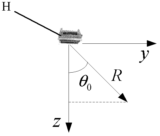
[0115] First use the Data_Output item in the software DeltaT_TCP that comes with the multibeam sonar to convert the obtained .837 file into a .83P file. The bytes used to express each Ping data in the .83P file are 0-1215, of which 256-424 bytes and 1122-1215 bytes are 0, and this part of redundant information is eliminated. For the data of 425-1121 bytes, the original multi-beam sonar topographic survey data is extracted every 24 bytes. Then according to the aforementioned multi-beam sonar topographic survey data P j Calculation step...


PUM


Abstract

The invention discloses a method for constructing a three-dimensional terrain vector model based on multi-beam sonar submarine measurement data, and relates to a method for constructing the three-dimensional vector terrain model with measurement data of multi-beam sonar, which solves the defect that a multi-beam ranging sensor can only provide discrete terrain elevation and can only query terrainparameters at a measurement point. The method is used for non-structural submarine terrain modeling and vector data retrieval. The method comprises the following steps of: acquiring a horizontal coordinate of a sampling point of the terrain of a submarine area and corresponding elevation data; defining a data structure of a terrain triangular net model according to characteristics of multi-beam sonar terrain measurement data; and finally, establishing a Delaunay triangular net vector model according to elevation data of each point of the multi-beam sonar terrain measurement and the data structure of a Delaunay triangular net.

Description

technical field [0001] The invention relates to a method for constructing a three-dimensional terrain model based on terrain measurement data, in particular to a method for building a three-dimensional vector terrain model based on multi-beam sonar measurement data. Background technique [0002] Due to the complex topography of the marine environment, harsh sea conditions, and unpredictable operational risks, it is impossible to directly complete the seabed topographic measurement and operations manually. In recent years, based on the acoustic ( Such as multi-beam sonar) and other sensors to perform seabed topography and landform measurement operations have become one of the safe and effective means and technological development trends in the field of marine survey and oceanographic investigation. However, the dedicated software of the acoustic sensor can only provide the user with a display interface of the measured terrain, and the dependence of its software platform makes...

Claims


Application Information

Patent Timeline
IPC IPC(8): G06T17/05
Inventor 王宏健傅桂霞边信黔徐健李娟陈兴华
Owner HARBIN ENG UNIV
Why Eureka
Try Eureka