Method for measuring soil water content

A soil water content and vegetation technology, which is applied in the field of soil water content detection, can solve the problems of poor reliability, lack of relevant model support, and insufficient use of visible light feature space information, etc., and achieves the effect of high measurement accuracy.

Active Publication Date: 2012-05-16
BEIJING RES CENT FOR INFORMATION TECH & AGRI
View PDF2 Cites 32 Cited by
  • Summary
  • Abstract
  • Description
  • Claims
  • Application Information

AI Technical Summary

Problems solved by technology

[0005] (1) Existing soil drought monitoring methods based on visible light, near-infrared or thermal infrared remote sensing data are all qualitative and relative trend expressions, and cannot obtain actual soil moisture content
[0006] (2) Lack of relevant mode

Method used


Image

  • Method for measuring soil water content
  • Method for measuring soil water content
  • Method for measuring soil water content

Examples


Embodiment Construction

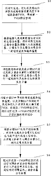
[0031] In order to make the purpose, content, and advantages of the present invention clearer, the implementation manners of the present invention will be further described in detail below in conjunction with the accompanying drawings.

[0032] Such as figure 1 As shown, the present invention proposes visible near-infrared and thermal infrared remote sensing data quantitative calculation soil water content method comprises the following steps:

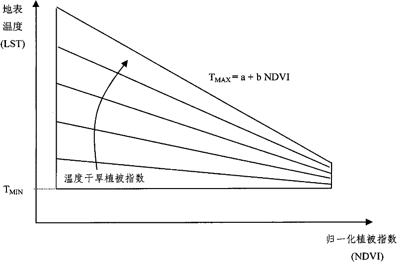
[0033] S1. Calculate TVDI (Temperature / Vegetation Dryness Index, Temperature Drought Vegetation Index) using remote sensing data (usually image data) in visible light, near infrared and thermal infrared bands to obtain the first TVDI feature space (in this embodiment, surface temperature and The feature space formed by NDVI can also be the feature space formed by vegetation temperature and NDVI, see below for the explanation of NDVI), the calculation formula is as follows:

[0034] TVDI = ...


PUM


Abstract

The invention discloses a method for measuring soil water content, which comprises the following steps of: S1, calculating a TVDI (Temperature Vegetation Dryness Index) by utilizing remote sensing data of visible light and near infrared and thermal infrared wave bands to obtain a first TVDI characteristic space; S2, setting different soil water contents according to ground meteorological observation data, then, inputting the data of the soil water contents into an ecological process model, and calculating vegetation temperature and surface temperature under the condition of different soil water contents; S3, inputting vegetation structural parameters and soil water contents into a radiation transmission model, and calculating a reflective spectrum of the visible light and the near infrared wave bands of vegetations under the condition of different soil water contents; S4, calculating the TVDI according to the vegetation temperature, the surface temperature and the reflective spectrum of the visible light and the near infrared wave bands to obtain a second TVDI characteristic space, and then carrying out slope division on the second TVDI characteristic space; S5, establishing a quantitative relationship equation between a slope and the soil water content Y; and S6, obtaining a space continuous coverage soil water content distribution result. The method for measuring the soil water content disclosed by the invention is capable of quantitatively measuring the soil water content and is high in precision.

Description

technical field [0001] The invention relates to the technical field of soil water content detection, in particular to a method for measuring soil water content. Background technique [0002] With the continuous development of remote sensing science and technology, vegetation drought monitoring using visible light, near-infrared and thermal infrared remote sensing data has received extensive attention. [0003] The main methods are: (1) Using visible and near-infrared data alone, constructing remote sensing indices related to the water deficit of vegetation itself, and finally indirectly estimating soil drought conditions through remote sensing indices. This method is affected by the physiological process of vegetation. In most cases, this indirect relationship is difficult to establish. That is, when the vegetation performs well, the surface soil moisture may have begun to lack, and there is a "time difference" between vegetation moisture and soil moisture, which leads to th...

Claims


Application Information

Patent Timeline
IPC IPC(8): G01N21/31G01N21/35G01N21/359
Inventor 赵春江杨贵军黄文江王纪华李存军宋晓宇徐新刚顾晓鹤杨小冬陈红
Owner BEIJING RES CENT FOR INFORMATION TECH & AGRI
Why Eureka
Try Eureka