High-resolution remote-sensing multifunctional urban land spatial information generation method

A high-resolution, spatial information technology, applied in the field of remote sensing information technology applications, can solve problems that are difficult to meet the application requirements of efficiency and practicability

Active Publication Date: 2012-06-27
INST OF GEOGRAPHICAL SCI & NATURAL RESOURCE RES CAS
View PDF7 Cites 45 Cited by
  • Summary
  • Abstract
  • Description
  • Claims
  • Application Information

AI Technical Summary

Problems solved by technology

The current spatio-temporal information detection of urban land use for complex structures is still based on the traditional method of combining a large number of field surveys with remote sensing, which is difficult to meet the application requirements of efficiency and practicability
Due to the hierarchical scale characteristics and complexity of the city's internal structure, it is difficult to meet the needs of urban multi-objective planning and management in the current urban land use classification. A multi-functio

Method used


Image

  • High-resolution remote-sensing multifunctional urban land spatial information generation method
  • High-resolution remote-sensing multifunctional urban land spatial information generation method
  • High-resolution remote-sensing multifunctional urban land spatial information generation method

Examples


Embodiment Construction

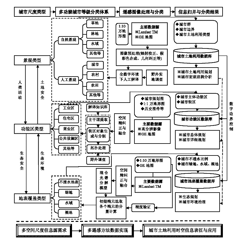
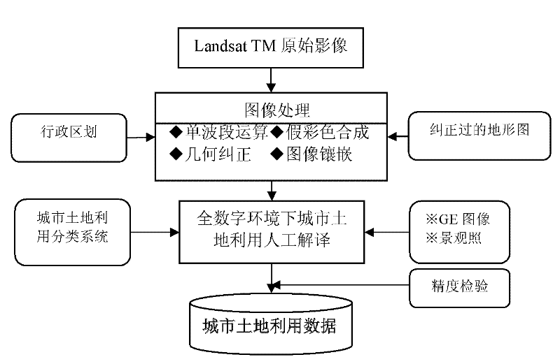
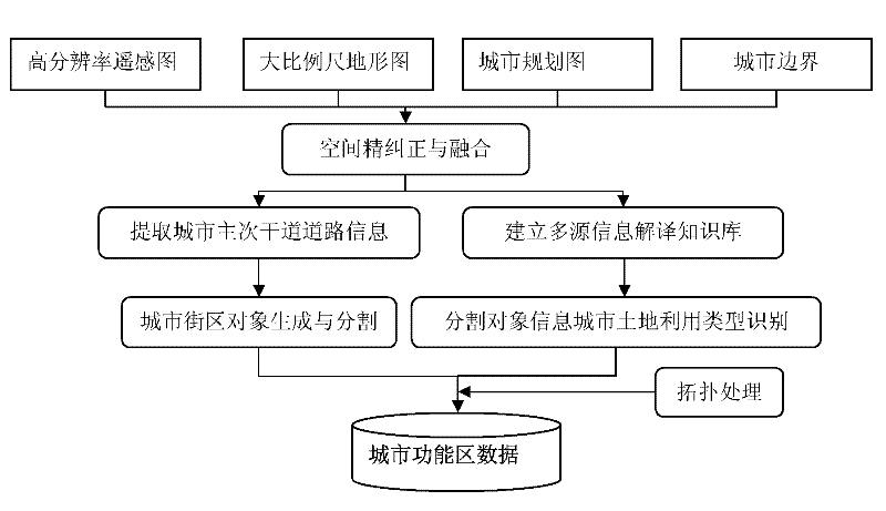
[0027] A kind of high-resolution remote sensing multifunctional urban land space information generation method of the present invention can be illustrated by the following examples:

[0028] (1) Spatial precise correction and registration of multi-source auxiliary information such as high-resolution remote sensing images, large-scale topographic maps, and urban planning maps.

[0029] Multi-source information fusion and reference is an important means in urban land use spatio-temporal information reconstruction methods, and it is necessary to pre-process a large number of map data, including basic image processing such as geometric correction, coordinate fitting, and projection transformation, so as to realize various Precise spatial positioning and mosaic of class map pieces.

[0030] (2) The establishment of an expert knowledge base for the identification and interpretation of multi-source information for urban land use classification.

[0031] Remote sensing image interpre...


PUM


Abstract

The invention discloses a high-resolution remote-sensing multifunctional urban land spatial information generation method. According to the method, a complex system rank theory is introduced; an urban land spatial information classification system with three rank scales, i.e. a multifunctional target landscape type, a functional area type and a land cover type, which self-adapts to urban planningmanagement and environmental renovation, is proposed; and on the basis of realizing the treatment of fine correction and alignment on remote-sensing images of a Landsat TM, a Google Earth and auxiliary maps, the Landsat TM is applied to carrying out urban landscape type classification, a three-level rank classification type-merged combination and an information mining knowledge base are constructed, the classified information is merged to form a first-level classification result of urban land, the digital functional areas are classified into a second level and the land cover is classified into a third level under the constrained control of higher-level classification information. The method has the characteristics of low cost, high accuracy of classification and strong targeted application, and thus, the requirements on target applications, such as ecological urban design, urban environmental management and the like, are better met.

Description

technical field [0001] The invention belongs to the application field of remote sensing information technology used in the urban planning industry, and focuses on solving the problem of high-precision acquisition of spatial data of multi-functional objects, and realizes the problem of high-precision urban land use spatial information detection. It is mainly used in urban planning, overall planning of land use, Land survey and urban ecological environment improvement. Background technique [0002] From the first satellite Landsat-1 launched by the United States in 1972 to the latest Landsat-7, it has laid the foundation for human urban remote sensing research, providing new methods and means for human beings to understand the earth from multiple perspectives and scales. Landsat TM The image has high spatial resolution, spectral resolution, extremely rich information and high positioning accuracy, which can meet the analysis and compilation of special topics related to agricul...

Claims


Application Information

Patent Timeline
IPC IPC(8): G06F17/30
Inventor 匡文慧迟文峰
Owner INST OF GEOGRAPHICAL SCI & NATURAL RESOURCE RES CAS
Why Eureka
Try Eureka