Traffic accident site rapid mapping system based on image guiding

A technology of accident scene and traffic accident, which is applied in the system field of traffic accident scene survey technology, can solve the problems of complicated and time-consuming operation, loss of gray information of orthographic projection image, and unsatisfactory, so as to achieve the effect of improving efficiency and standardization

Active Publication Date: 2012-07-11
SHANGHAI JIAO TONG UNIV SUBEI RES INST
View PDF1 Cites 17 Cited by
  • Summary
  • Abstract
  • Description
  • Claims
  • Application Information

AI Technical Summary

Problems solved by technology

Although this method avoids the complex three-dimensional modeling process and shortens the data processing time to a certain extent, it does not consider the impact of objective lens distortion on the scene of traffic accidents because it uses a simplified two-dimensional direct linear transformation formula to realize the orthographic transformation of traffic accident scene photos. The influence of image pixel coordinates, so its mapping accuracy is low
On the other hand, this method also needs to convert the image data into a vector format and import it into AutoCAD software to complete the drawing of the accident scene map.
In addition, when this method imports data into AutoCAD software, it also encounters the problem of losing all the gray information of the orthographic projection map, and only relies on the previously drawn vector information such as key points and lines to complete the drawing of the scene map

Method used


Image

  • Traffic accident site rapid mapping system based on image guiding
  • Traffic accident site rapid mapping system based on image guiding
  • Traffic accident site rapid mapping system based on image guiding

Examples


Embodiment Construction

[0037] Below in conjunction with accompanying drawing, the embodiment of the present invention is described in detail: present embodiment is implemented under the premise of the technical scheme of the present invention, has provided detailed implementation and specific operation process, but protection scope of the present invention is not limited to the following the embodiment.

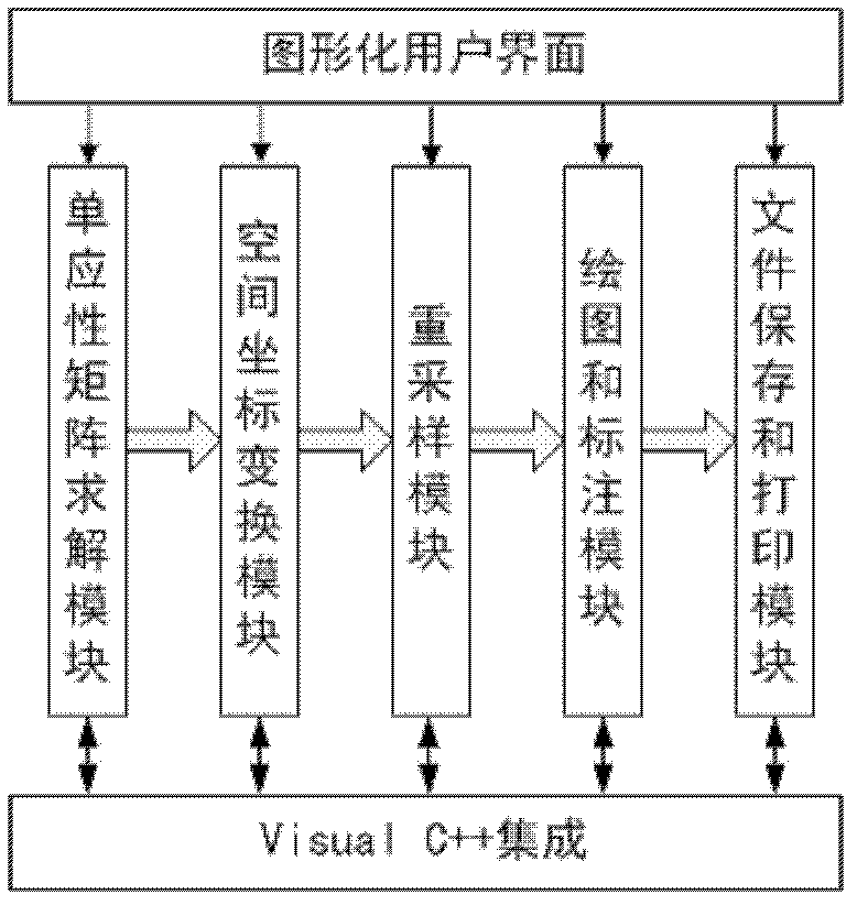
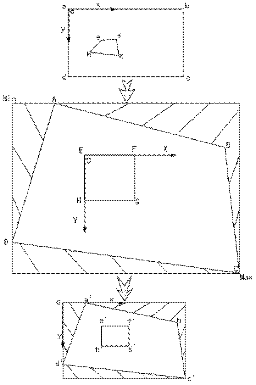
[0038] Such as figure 1 As shown, this embodiment includes five parts: a homography matrix solution module, a space coordinate transformation module, a resampling module, a drawing and labeling module, and a file saving and printing module. The homography matrix solving module establishes the mapping relationship between the accident scene photo image plane and the actual road plane according to the two-dimensional direct linear transformation method; the spatial coordinate transformation module restores the position information of the accident scene image in the object space according to the homog...


PUM


Abstract

A traffic accident site rapid mapping system based on image guiding comprises a homography matrix solution module, a space coordinate transformation module, a re-sampling module, a mapping and marking module and a file preserving and printing module. The homography matrix solution module builds a mapping relationship between a traffic accident site picture image plane and an actual road plane according to the two-dimensional direct linear transformation method, the space coordinate transformation module restores the position information of a traffic site picture in object space according to the homography matrix and scales the range of the traffic accident site to the size range of the original traffic accident site picture, the re-sampling module restores gray information of the traffic accident site picture in object space and achieves transformation from a perspective picture to an orthographic projection picture of the traffic accident site picture, the mapping and marking module achieves direct mapping and relevant size marking of the traffic accident site information on the orthographic projection picture, and the file preserving and printing module achieves functions of preservation and site printout of the traffic accident site picture. By means of the traffic accident site rapid mapping system, the accuracy of traffic accident site survey is improved, the on-site data processing and mapping time is saved, and the requirement of site picture printout on the traffic accident site is further satisfied.

Description

technical field [0001] The invention relates to a system in the technical field of traffic accident scene survey, in particular to an image-guided rapid traffic accident scene surveying and mapping system. Background technique [0002] Existing photogrammetry software such as PhotoModeler, iWitness, etc., are mainly used for high-precision 3D modeling of traffic accident scenes. Although they can greatly shorten the data collection time of the accident scene, the subsequent data processing and drawing process are complex and time-consuming, and it is difficult to meet the requirements of drawing an output scene map at the accident scene. When operating these softwares, it is generally necessary to carry out complex orientation processing on the photos of the accident scene, and then describe some key points, lines and surfaces on the photos, and finally only establish the 3D models of these key points, lines and surfaces. Due to the limited drawing and labeling functions of...

Claims


Application Information

Patent Timeline
Patent Type & Authority Applications(China)
IPC IPC(8): G01C11/00G01C11/04
Inventor 苗新强金先龙陈德户王小庆韩学源
Owner SHANGHAI JIAO TONG UNIV SUBEI RES INST
Why Eureka
Try Eureka