Quick monitoring method for soil erosion rate

A technology of soil erosion and rate, which is applied in the direction of soil material testing, material inspection products, etc., can solve the problems of measurement error and heavy workload, and cannot solve the problems of exposed or buried erosion needles, so as to reduce labor intensity, avoid human disturbance, and be practical wide range of effects

Active Publication Date: 2012-07-11
芷兰生态环境建设有限公司
View PDF5 Cites 10 Cited by
  • Summary
  • Abstract
  • Description
  • Claims
  • Application Information

AI Technical Summary

Problems solved by technology

However, for a long time, the production of erosion needles has not yet formed a standardized standard, and the corresponding measurement tasks need to be completed with the help of traditional measurement work, which cannot solve the problem of exposed or buried erosion needles, resulting in large measurement errors and workload, especially for vegetation coverage. Low monitoring sample plots cannot avoid human disturbance on the ground surface, which will affect the measurement accuracy

Method used


Image

  • Quick monitoring method for soil erosion rate
  • Quick monitoring method for soil erosion rate
  • Quick monitoring method for soil erosion rate

Examples


Embodiment 1

[0028] Embodiment 1 applies the soil erosion scale of the water erosion area to carry out the mensuration of soil erosion rate

[0029] In the runoff sub-district, measure soil erosion rate with the inventive method, it comprises the steps:
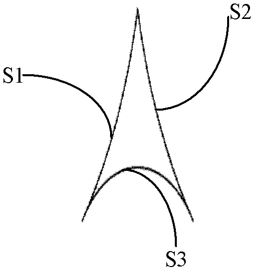
[0030] 1) The area of ​​the selected runoff plot is 50m 2 , the aforementioned soil erosion scale in the water erosion area ( figure 1 , figure 2 ) is buried vertically on the surface of the monitoring sample plot, the 0 scale line is flush with the surface, and the positive value part is buried below the surface, so that one end of the diverging line of the erosion scale (that is, the two arc surfaces with longer arc length and larger radius) Intersecting edges) face the direction of water flow. A total of 4 columns and 5 rows of erosion scales are arranged, with a column spacing of 0.5m and a row spacing of 1m. A total of 20 erosion scales are arranged and numbered sequentially;

[0031] 2) According to the predetermined monitoring...

Embodiment 2

[0036] Embodiment 2 applies the soil erosion scale in wind erosion area to carry out the mensuration of soil erosion rate

[0037] In the wind tunnel, the wind erosion monitoring of autumn plowing and harrowing has been simulated, including the following steps:

[0038] 1) The area of ​​the selected monitoring area is 2m 2 , the aforementioned soil erosion scale in the wind erosion area ( image 3 , Figure 4 ) is vertically buried on the surface of the monitoring sample land, the 0 scale line is flush with the surface, and the positive value part is buried below the surface, so that the sharp end of the erosion scale (that is, the edge with a smaller angle on the adjacent two sides) faces the wind direction. 3 columns and 3 rows, with a column spacing of 0.3m and a row spacing of 0.5m. A total of 9 erosion scales are arranged and numbered sequentially;

[0039] 2) According to the predetermined monitoring time requirements, read out the scale numbers of each erosion scale ...

Embodiment 3

[0045] Embodiment 3 Application of wind erosion area soil erosion scale to carry out the mensuration of soil erosion rate

[0046] The wind erosion monitoring of bare sandy land was completed outdoors, including the following steps:

[0047] 1) The area of ​​the selected monitoring area is 100m 2 , the aforementioned soil erosion scale in the wind erosion area ( image 3 , Figure 4 ) is vertically buried on the surface of the monitoring sample land, the 0 scale line is flush with the surface, and the positive value part is buried below the surface, so that the sharp end of the erosion scale (that is, the edge with a smaller angle on the adjacent two sides) faces the wind direction. 10 columns and 5 rows, with a column spacing of 1m and a row spacing of 2m, a total of 50 erosion scales are arranged and numbered sequentially;

[0048] 2) According to the predetermined monitoring time requirements, read out the scale numbers of each erosion scale sequentially by means of a di...


PUM


Abstract

The invention discloses a quick monitoring method for soil erosion rate, which comprises the following steps: 1) in a preselected monitoring region, laying out erosion scales in rows and columns, wherein the erosion scales are perpendicular to the monitoring sample plot surface, a zero graduation line and a gas cylinder on the surface of earth, and numbering orderly; 2) according to a predetermined monitoring system, taking photos of each erosion scale by a high-definition digital camera, and ensuring clear imaging of the erosion scales; 3) according to the number sequence, reading buried or exposed height of each erosion scale orderly by using an instant browsing function and an image amplifying tool of a camera, or by means of a computer; and 4) calculating the soil erosion amount. According to the method of the invention, a large amount of building projects of a runoff plot are abandoned, the monitoring precision on par with the runoff plot is achieved, the artificial disturbance of the traditional measuring method to the monitoring sample plot surface is avoided, the precision of the soil erosion rate measuring method with erosion needle can be increased, moreover, the labor intensity of the measuring workers is greatly reduced, and the working efficiency is increased.

Description

technical field [0001] The invention belongs to the field of soil erosion monitoring and relates to a method for monitoring rapid rate of soil erosion. Background technique [0002] my country is one of the countries with the most serious water and soil erosion in the world. At present, the area of ​​water and soil erosion in my country reaches 3.5692 million square kilometers, and the economic loss caused by water and soil erosion reaches hundreds of billions of yuan every year. Soil erosion is a basic form of surface material migration, and it is also one of the major environmental problems facing the world today. The related research on soil erosion mechanism, erosion rate monitoring and control countermeasures has become an important research content in the fields of geosciences and biology. It has been an important research topic for soil and water conservation workers for a long time. [0003] The existing soil erosion rate monitoring methods for field observation mai...

Claims


Application Information

Patent Timeline
Patent Type & Authority Applications(China)
IPC IPC(8): G01N33/24
Inventor 祁有祥杨建英赵廷宁辜再元
Owner 芷兰生态环境建设有限公司
Why Eureka
Try Eureka