Method for sea-land vector map data integration and fusion

A vector map data and graph data technology, applied in the field of geographic information system spatial data processing, can solve the problems of slow processing speed, heavy workload, and poor matching of complex-shaped surface entities, etc., to reduce the size and increase the speed Effect

Active Publication Date: 2012-07-11
哈尔滨哈船导航技术有限公司
View PDF2 Cites 37 Cited by
  • Summary
  • Abstract
  • Description
  • Claims
  • Application Information

AI Technical Summary

Problems solved by technology

This method mainly focuses on the building surface entity in the city map, but it cannot match well other complex shape surface entities (such as lakes, islands, etc.)
For the existing surface entity matching methods, most of them have the characteristics of heavy workload, slow processing speed, and complex data processing process, which makes it time-consuming and laborious to process vector data in large quantities.

Method used


Image

  • Method for sea-land vector map data integration and fusion
  • Method for sea-land vector map data integration and fusion
  • Method for sea-land vector map data integration and fusion

Examples


Embodiment Construction

[0025] The present invention will be further described in detail with reference to the accompanying drawings and embodiments.

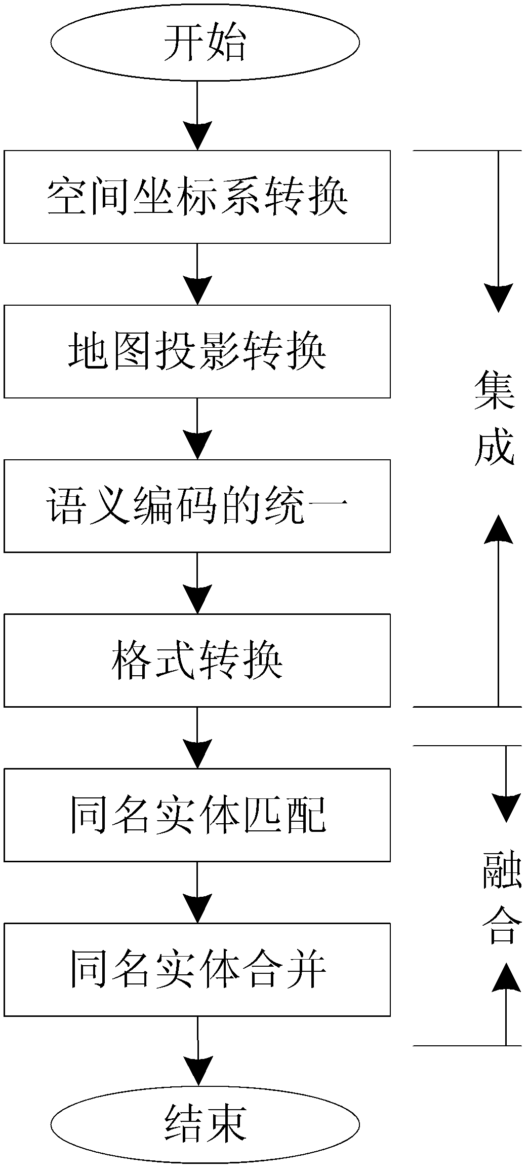
[0026] The present invention is a method for integrating and merging sea and land vector map data, the process is as follows figure 1 shown, including the following steps:

[0027] Step 1: Preprocessing of land and sea vector map data.

[0028] Read the position data in the nautical chart data file and the land map data file respectively. If the longitude and latitude coordinates of a certain point are read as (x, y), perform the following conversion on all position coordinates (x, y) to obtain the predicted processed data.

[0029] Specifically:

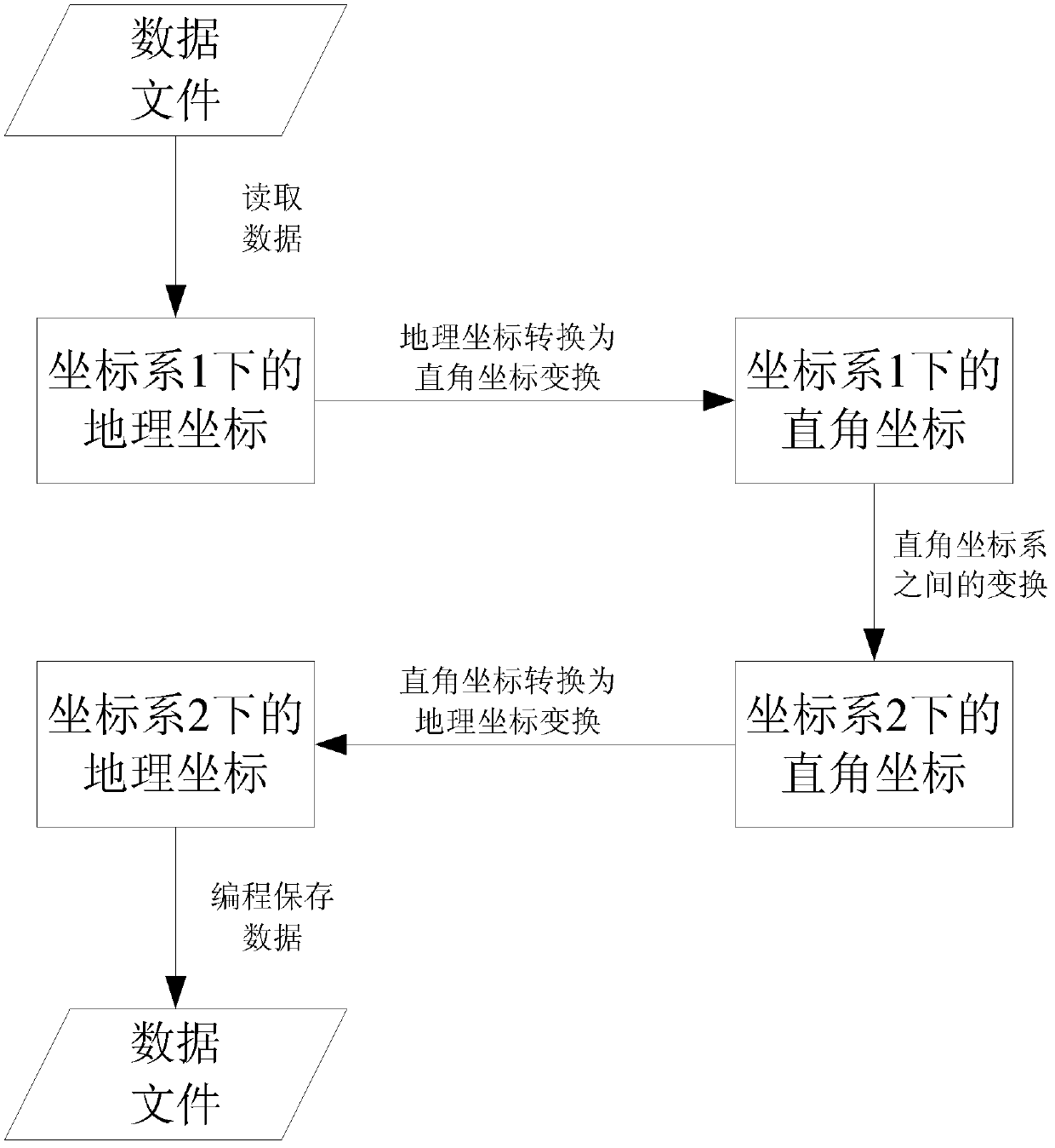
[0030] (1) Transformation of the coordinate system

[0031] Process such as figure 2 As shown, where, when coordinate system 1 is a chart coordinate system, coordinate system 2 is a land map coordinate system; when coordinate system 1 is a land map coordinate system, coordinate system 2 is a sea chart...


PUM


Abstract

The invention discloses a method for sea-land vector map data integration and fusion, which includes the steps of data pre-treatment, data format conversion, data integration display, same-name entity matching, same-name entity combination and the like. A digital audio tape (DAT) data format put forward by the method enables map control information, index data and position coordinate data to be packaged on one file and stored with layers as the unit. The storage format is convenient for management of layers, and when data of a corresponding layer is read, the data file only needs to be opened once, so that data reading speed of data is greatly improved, and simultaneously the size of the map data file is reduced to a certain degree. In addition, the same-name surface entity matching method based on simplification of polygon is capable of replacing all point entities forming a surface entity with four points or eight points obtained through simplification to participate in a matching process, thereby being capable of reducing complexity, improving matching rate, and simultaneously being capable of storing simplified results to be in the mode of files to be convenient for secondary use.

Description

technical field [0001] The invention relates to an integration and fusion method of sea and land vector map data, belonging to the technical field of geographic information system spatial data processing. Background technique [0002] The data fusion of sea and land vector maps can integrate the information of vector sea charts and vector land maps, so it can eliminate the single information and space limitations brought by a single vector sea map or a single vector land map data, and obtain rich information and high quality. Higher information can better meet people's application needs. With the application of geographic information system more and more widely, people's demand for geospatial vector data is more and more urgent, and sea and land vector data often have differences in spatial reference, semantic coding, storage format, etc., which makes sea and land vector data The integration and fusion of map data has been widely used. [0003] Data integration is the logi...

Claims


Application Information

Patent Timeline
Patent Type & Authority Applications(China)
IPC IPC(8): G06F17/30
Inventor 张振兴张敏赵玉新李刚沈志峰刘厂
Owner 哈尔滨哈船导航技术有限公司
Why Eureka
Try Eureka