Construction method of urban geographic information data warehouse

A technology of geographic information data and construction methods, applied in the direction of electrical digital data processing, special data processing applications, instruments, etc., can solve inaccurate processing results, loss of spatial and temporal characteristics of industrial land, topological relationship, and loss of spatial characteristics and other issues to achieve the effect of improving monitoring efficiency, reducing data extraction costs, and improving efficiency

Inactive Publication Date: 2012-10-24
天津市规划信息中心
View PDF2 Cites 20 Cited by
  • Summary
  • Abstract
  • Description
  • Claims
  • Application Information

AI Technical Summary

Problems solved by technology

[0005] To a certain extent, these massive data have exceeded the analysis and processing capabilities of traditional geographic information systems, making the efficiency of query and analysis slow. For example, urban geographic information data in Tianjin has grown rapidly from GB, TB to PB. When traditional geographic information systems process massive data, the waiting time for graphic browsing and printing output is long, which cannot meet the requirements for high-performance, large-capacity distributed storage and management
Secondly, traditional data warehouses have great limitations in processing spatial data and cannot support spatial feature data. They are usually con

Method used


Image

  • Construction method of urban geographic information data warehouse
  • Construction method of urban geographic information data warehouse
  • Construction method of urban geographic information data warehouse

Examples


Embodiment Construction

[0041] In order to make the object, technical solution and advantages of the present invention clearer, the implementation manner of the present invention will be further described in detail below in conjunction with the accompanying drawings.

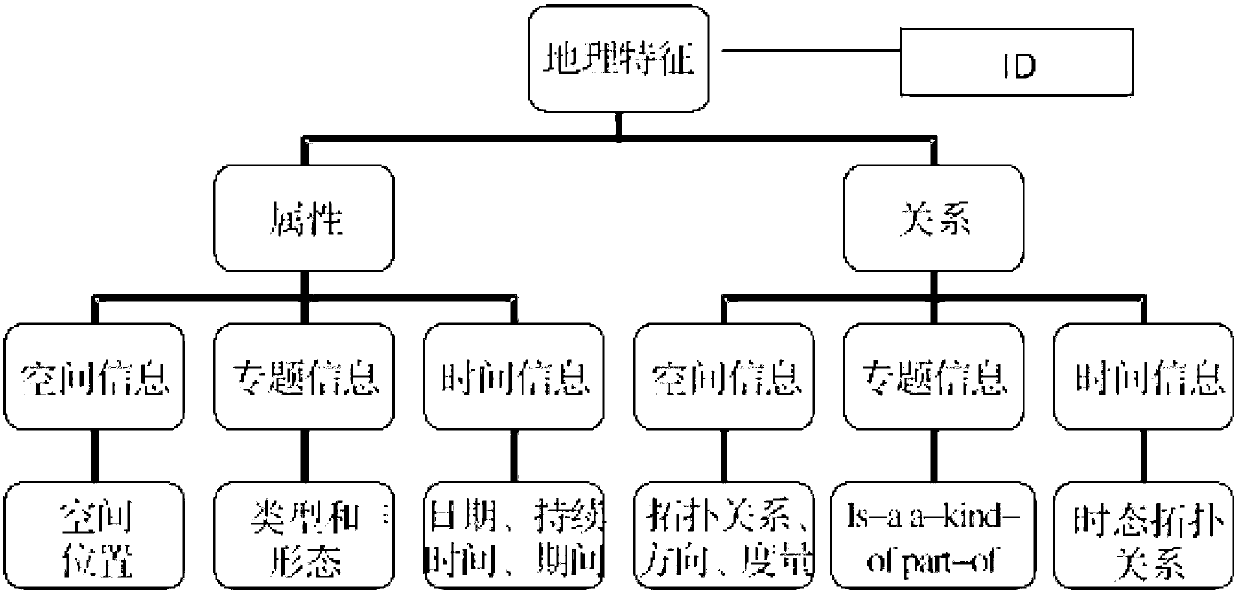
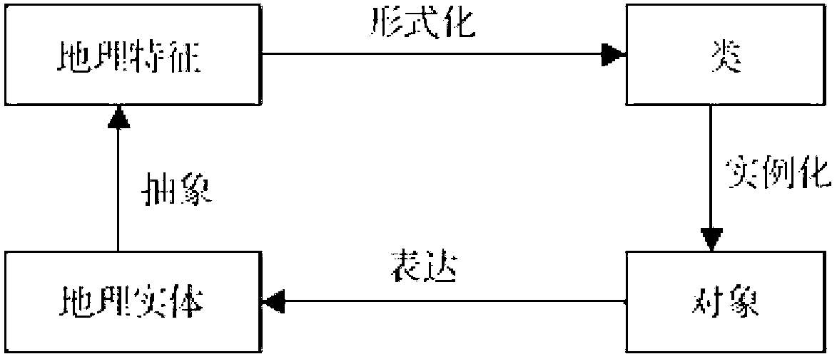
[0042] In order to realize the conversion from spatial feature data to non-spatial data, make the processing results accurate, and improve the efficiency of query and analysis, the embodiment of the present invention provides a method for constructing an urban geographic information data warehouse, see figure 1 with Figure 4 , see the description below:

[0043] The feature-based modeling method appeared in the 1970s and 1980s, and it is a new method proposed relative to the layer organization method of spatial data. Compared with the traditional layer-based geographic relationship model, the feature-based GIS modeling method is a modeling method at a higher level of abstraction, which has a better cognitive view of geographic inform...


PUM


Abstract

The invention discloses a construction method of an urban geographic information data warehouse. Original spatial data are processed when missing data, repeating data and abnormal data exist, according to spatial characteristics of time type data, space type data and time and space mixed type data, all record values minus a record average value by a mean and sigma method and are divided by a record value standard deviation to obtain processed data; a model based on spatial characteristics according to the processed data is built to obtain an urban geographic information data warehouse; and data changes in the original spatial data are monitored, data are extracted and updated according to a design feature object data table, when a preset time is up, the updated data are added into the urban geographic information data warehouse. The construction method of the urban geographic information data warehouse has the advantages of being capable of improving the query, analysis and monitoring efficiency and reducing the data extraction cost.

Description

technical field [0001] The invention relates to the field of urban geographic information systems, in particular to a method for constructing an urban geographic information data warehouse. Background technique [0002] GIS (Geographic Information System, geographic information system) has become a management application information system for storage, management, query, simple analysis and result display. Storage and management, and relatively simple auxiliary decision-making analysis, after years of hard work, its related technologies and tools have been perfected and gradually matured. [0003] With the diversified development of society, every city collects and stores a large amount of spatial basic data and industry attribute data, and it is growing at a rate of terabytes all the time. [0004] In the process of realizing the present invention, the inventor finds that at least the following disadvantages and deficiencies exist in the prior art: [0005] To a certain e...

Claims


Application Information

Patent Timeline
IPC IPC(8): G06F17/30
Inventor 才睿俞斌吴广竹殷响林张嘉瑞
Owner 天津市规划信息中心
Why Eureka
Try Eureka