Flight path synthetic method in unmanned aerial vehicle visual navigation

A synthesis method and visual navigation technology, applied in the field of visual navigation, can solve problems such as difficult to meet real-time performance and large amount of calculation

Inactive Publication Date: 2012-11-21
TIANJIN POLYTECHNIC UNIV
View PDF0 Cites 19 Cited by
  • Summary
  • Abstract
  • Description
  • Claims
  • Application Information

AI Technical Summary

Problems solved by technology

This type of method has strong robustness, can be applied in complex environments, and is the development direction of natural

Method used


Image

  • Flight path synthetic method in unmanned aerial vehicle visual navigation
  • Flight path synthetic method in unmanned aerial vehicle visual navigation
  • Flight path synthetic method in unmanned aerial vehicle visual navigation

Examples


Embodiment Construction

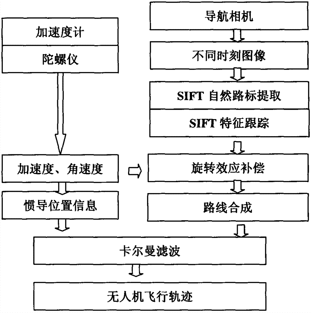
[0012] The specific design ideas of the main links are as follows:

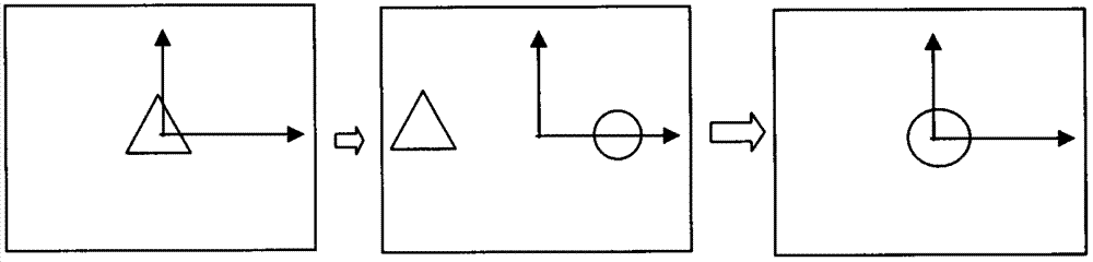
[0013] (1) UAV rotation effect compensation

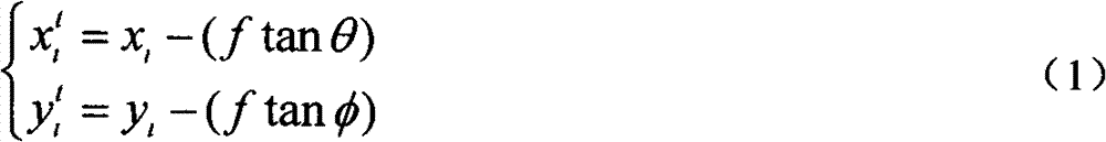
[0014] The rotation effect of the drone has an impact on the displacement of the feature points in the image. Therefore, after the feature point position information, the influence of the rotation effect should be removed. Euler angles (θ, φ) and angular velocity (ω x , ω y , ω z ), based on formula (1) and formula (2).

[0015] x i t = x i - ( f tan θ ) y i t = ...


PUM


Abstract

The invention studies a flight path synthetic method in an unmanned aerial vehicle visual navigation system. During navigation information acquisition by image characteristic matching, the rotation problem of the unmanned aerial vehicle can not be ignored. According to the invention, euler angles and angular velocity measured by an inertial navigation system is used for the compensation of rotation effect, and then a complete flight path based on visual information is synthesized according to a movement track of a road sign in the image. The position information of the unmanned aerial vehicle is resolved by the image (pixel displacement) coordinate transformation relation of the natural road sign within a certain time interval. The flight path synthetic method in unmanned aerial vehicle visual navigation studied in the invention is suitable for the characteristics of high positioning precision, micromation and low cost of small and medium-size unmanned aerial vehicles, and has theoretic and practical value.

Description

technical field [0001] The invention belongs to the field of visual navigation, and relates to a research on a flight path synthesis method in the visual navigation of an unmanned aerial vehicle. Background technique [0002] Unmanned Aerial Vehicle (UAV) plays an increasingly important role in military and civilian use. Advanced navigation system is the key to determine the completion of combat missions and improve survivability of UAV. In the past ten years, significant progress has been made in the development of positioning, tracking, autonomous information processing and unmanned aerial vehicles, such as modern satellite navigation technology, inertial navigation system, communication and monitoring technology, etc. In addition, new visual perception and Processing equipment has also been equipped on drones. At present, the widely used UAV navigation method is GPS navigation. Due to the certain environmental limitations of its use, terrain-based navigation (TRN) appear...

Claims


Application Information

Patent Timeline
IPC IPC(8): G01C21/20
Inventor 成怡
Owner TIANJIN POLYTECHNIC UNIV
Why Eureka
Try Eureka