Navigation system and its path designing method

A navigation system and path planning technology, applied in navigation, surveying and mapping, road network navigator, etc., can solve the problems of increased waiting time for road condition information and users' inability to download road condition information, so as to increase the utilization rate and improve the practicality and practicability, improving the effect of application simplicity

Inactive Publication Date: 2012-12-19
INVENTEC(NANJING) TECH CO LTD +2
View PDF3 Cites 14 Cited by
  • Summary
  • Abstract
  • Description
  • Claims
  • Application Information

AI Technical Summary

Problems solved by technology

However, this method increases the waiting time for downloading the traffic information due to the advance calculation of the remote server, and once the remote server is abnormal or crashes, it will cause the user to be unable to download the traffic information.

Method used


Image

  • Navigation system and its path designing method
  • Navigation system and its path designing method
  • Navigation system and its path designing method

Examples


Embodiment Construction

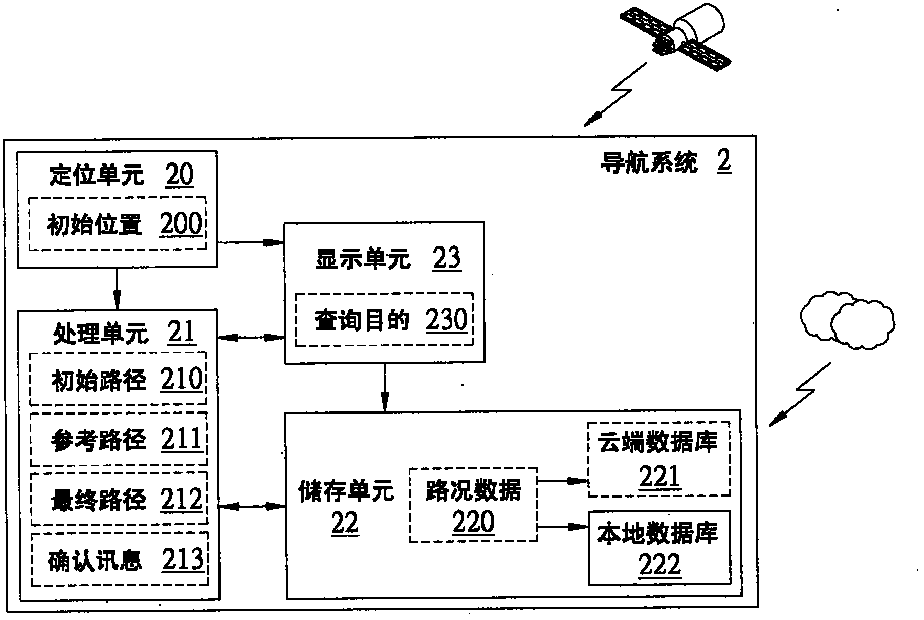
[0043] Embodiments of the navigation system and route planning method according to the present invention will be described below with reference to related drawings. For ease of understanding, the same components in the following embodiments are described with the same symbols.

[0044] see figure 1 , which is a structural diagram of an embodiment of the navigation system of the present invention. As shown in the figure, the navigation system 2 includes a positioning unit 20 , a processing unit 21 , a storage unit 22 and a display unit 23 . The storage unit 22 may include a cloud database 221 disposed in the cloud server and a local database 222 in the navigation system. The local database 222 can be a built-in memory or an external memory card, such as CF (Compact Flash), MD (Micro Drive), SD (Secure Digital) or MMC (Multi Media Card) and other memory cards, but not limited. In this embodiment, the storage unit 22 can have both the cloud database 221 and the local database 2...


PUM


Abstract

The invention discloses a navigation system and a method for planning a route thereof. The navigation system includes a storage unit and a processing unit. A cloud database of a cloud server and a local database of the navigation system are allocated in the storage unit, which is configured to store road condition data. The processing unit is connected to the storage unit, and generates an initial route according to an initial location and a destination. The processing unit also compares, computes and analyses the initial route and the road condition data, corresponding to at least one road section of the initial route, stored in the storage unit to generated a plurality of reference routes. Next, one of the reference routes is selected as a final route.

Description

technical field [0001] The present invention relates to a navigation system and a path planning method thereof, in particular to a navigation system utilizing a cloud database data sharing mechanism and a path planning method thereof. Background technique [0002] With the popularization of mobile devices and the development of wireless network applications, various mobile devices continue to increase navigation functions related to Global Positioning System (Global Positioning System, GPS) or satellite positioning, such as smart phones (Smart Phone), Personal digital assistant (Personal Digital Assistant, PDA) or tablet computer (Tablet PC), etc., to facilitate users to grasp the real-time activity path or peripheral information of the activity range at any time. However, when a user uses a mobile device to use the navigation function, problems often occur that the route planned by the navigation system cannot be followed. The routes provided by the navigation system do no...

Claims


Application Information

Patent Timeline
Patent Type & Authority Applications(China)
IPC IPC(8): G01C21/34
CPCG01C21/34G01C21/3492
Inventor 韩接才万康军
Owner INVENTEC(NANJING) TECH CO LTD
Why Eureka
Try Eureka