Method for automatically extracting newly added construction land change image spot of high-resolution remote sensing image

A remote sensing image, high-resolution technology, applied in the field of image processing, can solve problems such as extraction, and achieve the effect of simple method and high degree of automation

Active Publication Date: 2013-01-02
NANJING UNIV
View PDF4 Cites 30 Cited by
  • Summary
  • Abstract
  • Description
  • Claims
  • Application Information

AI Technical Summary

Problems solved by technology

[0005] Purpose of the invention: In view of the problems and deficiencies in the above-mentioned prior art, the purpose of the present invention is to provide a method for automatically extracting new constructi

Method used


Image

  • Method for automatically extracting newly added construction land change image spot of high-resolution remote sensing image
  • Method for automatically extracting newly added construction land change image spot of high-resolution remote sensing image
  • Method for automatically extracting newly added construction land change image spot of high-resolution remote sensing image

Examples


Embodiment Construction

[0024] Below in conjunction with accompanying drawing and specific embodiment, further illustrate the present invention, should be understood that these embodiments are only for illustrating the present invention and are not intended to limit the scope of the present invention, after having read the present invention, those skilled in the art will understand various aspects of the present invention Modifications in equivalent forms all fall within the scope defined by the appended claims of this application.
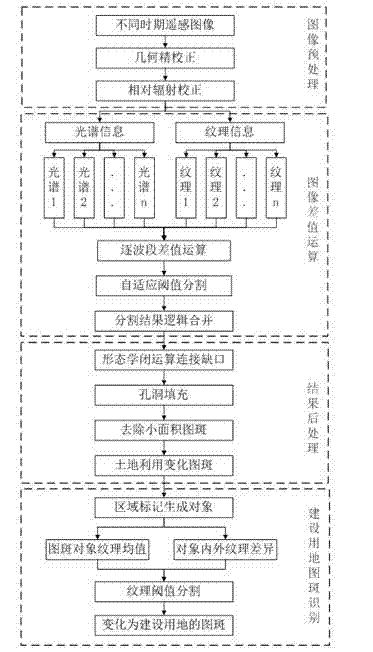
[0025] The basic idea of ​​the present invention is to design an automatic extraction method for newly added construction land change map spots from coarse to fine high-resolution remote sensing images. The main process is as follows: input two phases of remote sensing images in different periods, after preprocessing, calculate the gray level co-occurrence matrix texture features (variance, Variance) of each band, and perform difference calculation between the texture and...


PUM


Abstract

The invention discloses a method for automatically extracting a newly added construction land change image spot of a high-resolution remote sensing image. The method comprises the following steps: inputting two high-resolution remote sensing images of a same area at different periods and performing geometrical fine calibration and relative radiation calibration; respectively calculating textural features of all wave bands of the images at two periods; performing difference value operation on the textural features and the spectral signature of the images by waveband, thereby obtaining a difference value image and cutting thresholds; logically combining two-value result images of all wave bands; performing morphological closed operation, hole filling and small-area image spot removing treatment on the two-value result images after being logically combined in turn, thereby obtaining a change image spot of land utilization; making zone marks on the change image spot of land utilization so as to generate an image spot object; calculating the textural features of each image spot object in a remote sensing image at a new period; and extracting the newly added construction land change image spot. According to the method provided by the invention, the problem of extracting the newly added construction land is mainly solved, and meanwhile, the capacity of detecting the interior change of the construction land is achieved.

Description

technical field [0001] The invention relates to an image processing method, in particular to a method for automatically extracting new construction land change map spots in high-resolution remote sensing images. Background technique [0002] In recent years, with the rapid development of my country's economy and the rapid growth of population, the scale of cities has been expanding, and the area of ​​construction land has increased sharply. The continuous increase of land for urban construction has taken up cultivated land resources to varying degrees. At present, my country implements the most stringent farmland protection policy, and government departments at all levels urgently need to obtain accurate information on land use changes, especially the conversion of agricultural land to construction land. In addition, timely and accurate construction land change information is of great value for research and application fields such as urban planning, urban expansion, and urb...

Claims


Application Information

Patent Timeline
IPC IPC(8): G06K9/46
Inventor 肖鹏峰佘江峰王东广张学良
Owner NANJING UNIV
Why Eureka
Try Eureka