Non-horizontalization free established station for total station and project measurement method of non-horizontalization free established station
What is AI technical title?
AI technical title is built by Patsnap AI team. It summarizes the technical point description of the patent document.
A measurement method and the technology of a total station, which are applied in the field of setting up a total station
Active Publication Date: 2013-01-09
JIANGXI EVERBRIGHT MEASUREMENT & CONTROL TECH CO LTD
View PDF4 Cites 33 Cited by
Summary
Abstract
Description
Claims
Application Information
AI Technical Summary
This helps you quickly interpret patents by identifying the three key elements:
Problems solved by technology
Method used
Benefits of technology
Problems solved by technology
[0003] The purpose of the present invention is to provide a total station free leveling method to overcome the technical problem that the existing total station can only be accurately leveled first and then set up in actual engineering applications
Method used
Image
Click on the blue label to locate the original text in one second.
Reading with bidirectional positioning of images and text.
Examples
Embodiment 1
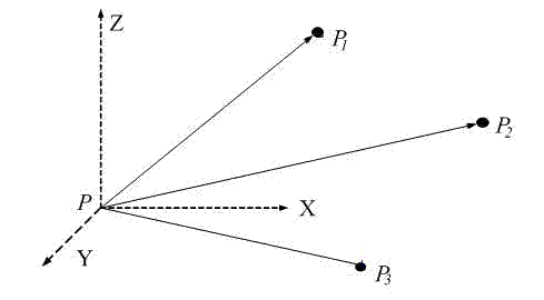
[0041] Calculation of the coordinates of the total station without leveling based on three known geodetic reference points: as attached figure 1 shown in P Set up the total station at the known geodetic datum point P 1 、P 2 、P 3 Place a prism on the point and measure the total station site P The oblique distances between the three prisms are s 1 , s 2 , s 3 . make P 1 The geodetic coordinates of the point are ( x 1 , y 1 , z 1 ), P 2 The geodetic coordinates of the point are ( x 2 , y 2 , z 2 ), P 3 The geodetic coordinates of the point are ( x 3 , y 3 , z 3 ). order total station site P The geodetic coordinates are ( x 0 , y 0 , z 0 ), then the equation
[0042]
[0043] Since the problem is derived from a practical problem, there must exist a solution to the equation. Obtain the two solutions of the equation system by analytical method or numerical method, and then use the direction cosine matrix in formula (2) R The center...
Embodiment 2
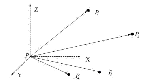
[0045] Calculation of the coordinates of the total station without leveling based on four known geodetic reference points: as attached figure 2 shown in P Set up the total station at the known geodetic datum point P 1 、P 2 、P 3 , P 4 Place a prism on the point and measure the total station site P The oblique distances between the four prisms are s 1 , s 2 , s 3 , s 4 . make P 1 The geodetic coordinates of the point are ( x 1 , y 1 , z 1 ), P 2 The geodetic coordinates of the point are ( x 2 , y 2 , z 2 ), P 3 The geodetic coordinates of the point are ( x 3 , y 3 , z 3 ), P 4 The geodetic coordinates of the point are ( x 4 , y 4 , z 4 ),. order total station site P The geodetic coordinates are ( x 0 , y 0 , z 0 ), then the equation
[0046]
[0047] Since the problem is derived from a practical problem, there must exist a solution to the equation. Solve this system of equations analytically or numerically, passing t...
Embodiment 3
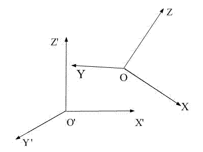
[0049] Total station free leveling measurement method: as attached image 3 as shown, XYZ is the internal coordinate system of the total station, X'Y'Z' It is the earth coordinate system, to realize the transformation of the two coordinate systems, first translate XYZ origin of the coordinate system O , make it with X'Y'Z' The coordinate origin O' coincides (as attached Figure 4 ), get the coordinate translation [ ΔX ΔY ΔZ ] T ;
[0050] The three-dimensional coordinate transformation model according to formula (2)
[0051]
[0052] The scale ratio between the internal coordinate system of the total station and the earth coordinate system mu Equal to 1, coordinate translation [ ΔX ΔY ΔZ ] T is the site coordinates of the total station P ( x 0 , y 0 , z 0 ), which can be obtained by the formula (1) of the total station without setting up the station freely.
[0053] That is, formula (2) can be transformed into:
[0054] (5)
[0055] in:
[0...
PUM
Abstract
The invention discloses a non-horizontalization free established station for a total station and a project measurement method of the non-horizontalization free established station. The invention belongs to the technical field of project measurement. The non-horizontalization free established station for the total station and the project measurement method are characterized in that (1) the total station is in a non-horizontal working gesture; the total station is operated to measure a slope distance, a horizontal angle and a zenith distance of at least thee geodetic datums; (2), according to the obtained measurement information of geodetic datums, a three-dimensional geodetic coordinate and gesture information of a total station point are obtained by using the method of non-horizontalization free established station for the total station; (3) the total station measures a point to be tested by the non-horizontal working gesture, and obtains the three-dimensional geodetic coordinate of the point to be tested through the measurement method of a non-horizontalization project of the total station. The invention solves technical problems of establishing a station, lofting and measuring only after flattening the total station in advance during project measurement, realizes the non-horizontalization free established station for the total station and project measurement of the non-horizontalization free established station; operation is simple; efficiency of field lofting and measuring works can be obviously improved.
Description
technical field [0001] The invention belongs to the technical field of engineering survey and relates to a method for setting up a total station. Background technique [0002] Modern total stations can not only measure distance and angle automatically, but also complete the processing of relevant information, such as the calculation of horizontal distance, height difference, elevation, coordinates, etc., and related applications such as station setting and stakeout. Indispensable high-efficiency, high-precision measuring instruments. At present, the methods for freely setting up total stations mainly include the method of resection of one side and one corner, distance resection of two sides, and resection of bilateral single corner. These free station setting methods are widely used in engineering practice. However, at present, the free station setting and measurement methods in engineering are based on the total station in the level state, and cannot be completed in the n...
Claims
Application Information
Patent Timeline
Application Date:The date an application was filed.
Publication Date:The date a patent or application was officially published.
First Publication Date:The earliest publication date of a patent with the same application number.
Issue Date:Publication date of the patent grant document.
PCT Entry Date:The Entry date of PCT National Phase.
Estimated Expiry Date:The statutory expiry date of a patent right according to the Patent Law, and it is the longest term of protection that the patent right can achieve without the termination of the patent right due to other reasons(Term extension factor has been taken into account ).
Invalid Date:Actual expiry date is based on effective date or publication date of legal transaction data of invalid patent.
IPC IPC(8): G01C15/00
Inventor陶捷朱洪涛
OwnerJIANGXI EVERBRIGHT MEASUREMENT & CONTROL TECH CO LTD

