Method for acquiring topographic profile information according to topographic map

A technology of terrain profile and terrain map, which is applied in image data processing, 2D image generation, instruments, etc., can solve the problems such as the inability of reviewers to verify the accuracy and authenticity of results, waste of technicians' time, and inaccurate cutting results. Accurate and reliable profile information, fast data processing, and improved efficiency

Active Publication Date: 2013-02-13
CHANGJIANG SURVEY PLANNING DESIGN & RES
View PDF2 Cites 7 Cited by
  • Summary
  • Abstract
  • Description
  • Claims
  • Application Information

AI Technical Summary

Problems solved by technology

[0002] Since MicroStation currently does not have software or tools for cutting sections on topographic maps, in the prior art, every time a worker needs to cut a topographic section, they can only open the topographic map with MicroStation on the computer and obtain the section by manual interpretation Horizontal distance, elevation, or a more primitive method, print out the graphics, measure the horizontal distance and elevation of the section with a ruler, and enlarge or reduce the corresponding manually measured plane position coordinates and elevation values ​​according to the proportional relationship. In this process , the workload is heavy and the operation is cumbersome, which greatly wastes the time of the technicians, and even some staff are impatient, omitting some steps and workload, resulting in inaccurate cutting results, and the auditors cannot test the accuracy and authenticity of the results. sex

Method used


Image

  • Method for acquiring topographic profile information according to topographic map
  • Method for acquiring topographic profile information according to topographic map
  • Method for acquiring topographic profile information according to topographic map

Examples


Embodiment 1

[0042] see figure 1 , figure 2 and image 3 As shown in the figure, the method of extracting the terrain profile information of the terrain map includes the following steps:

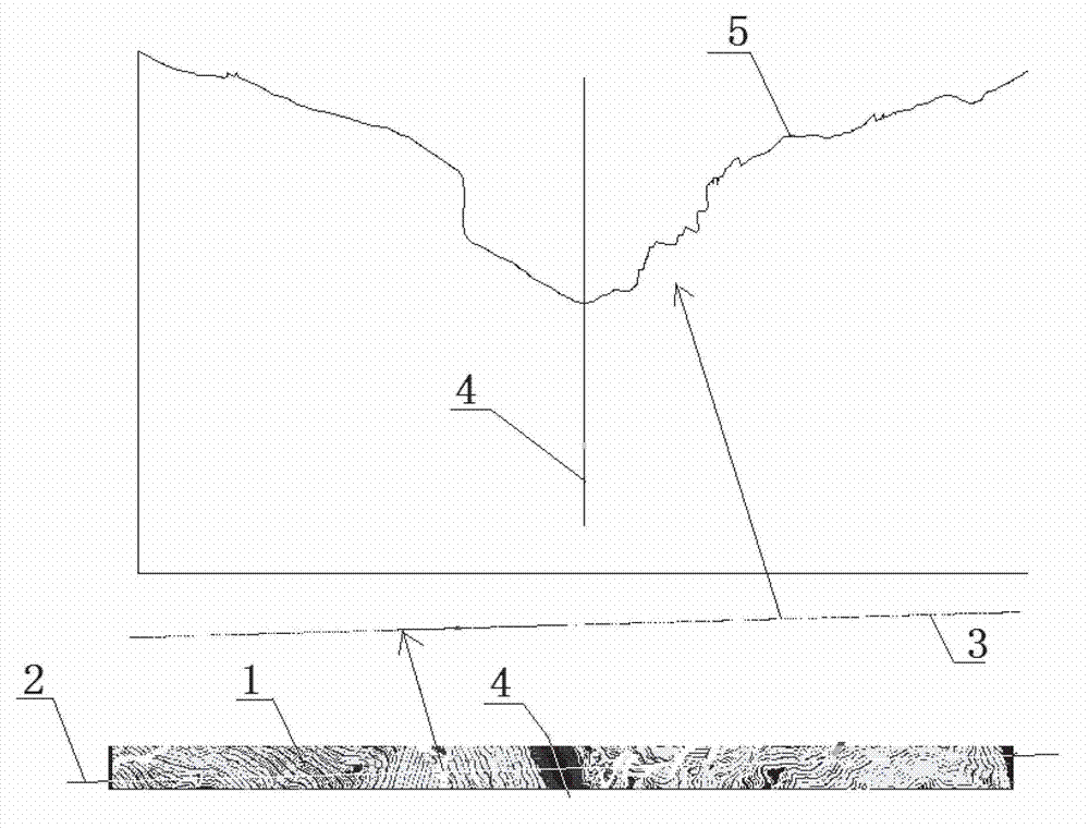
[0043] 1), image 3 middle ground figure 1 At the position to be cut, draw a section line 2, copy and translate the section line 2 by 0.001 meters; section line 2 adopts a straight line segment, of course, a polyline, arc, etc. can also be used;

[0044] 2) Use the fence to capture the four end points of the two parallel lines 2 in step 1), enclose the terrain line between the two parallel lines 2, and cut, copy and translate the enclosed terrain line. In addition to the original topographic map, each unit segment 3 of the topographic line is formed;

[0045] 3), extract the topographic plane position coordinates and elevation values ​​of the points on each unit segment 3 of the topographic line enclosed in step 2), and save them to a text file;

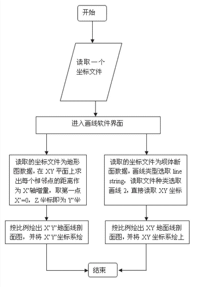
[0046] 4), extract the plane position coordinates XY...

Embodiment 2

[0055] like figure 1 , figure 2 and Figure 4 As shown in the figure, the method of extracting the terrain profile information of the terrain map includes the following steps:

[0056] 1), Figure 4 middle ground figure 1 At the position to be cut, draw a section line 2, and the section line 2 uses a straight line segment, of course, a polyline, an arc, etc. can also be used;

[0057] 2) Use the fence to capture the two endpoints of a section line 2 in step 1), and enclose the topographic line above section line 2; cut and copy the topographic line enclosed in step 2) to terrain figure 1 outside;

[0058] 3) Connect the endpoints of the cut terrain line with lines in turn to obtain the connection line 6 of each point where the section line and the terrain line intersect, then move the connection line 6 away, and surround it with a fence to extract the line segment 6. Topographic plane coordinates and elevation values ​​of each point, and save the extracted topographic ...

Embodiment 3

[0069] see figure 1 , figure 2 and Figure 5 As shown, the software designed by the method of the present invention is used in the technical field of cutting the dam body section, including the following steps:

[0070] 1), Figure 5 At the position where the dam body 7 needs to be cut in the top view, a section line 2 is drawn, and the section line 2 is copied and translated by 0.001 meters;

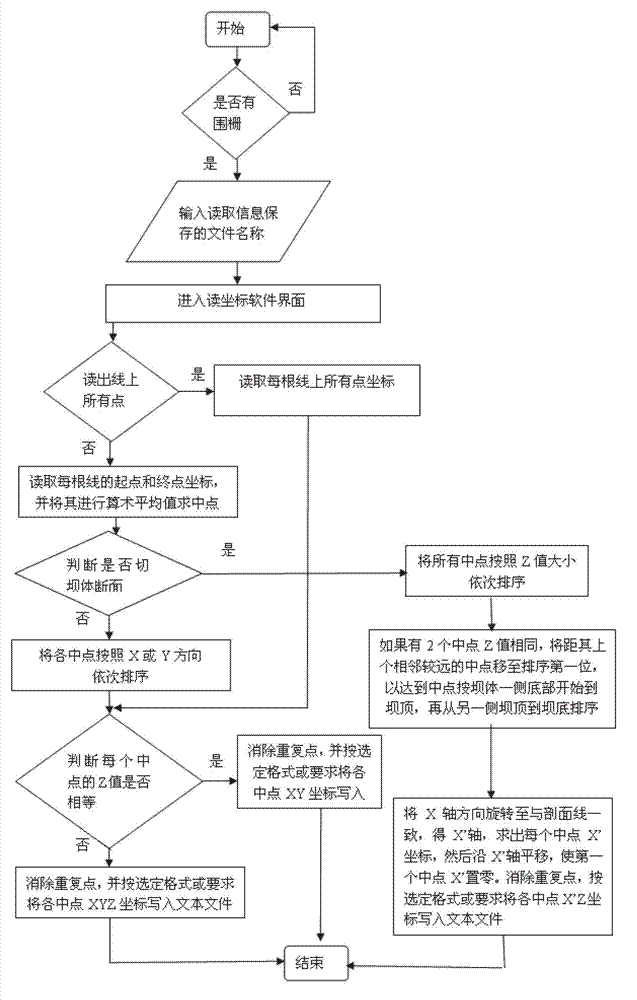
[0071] 2) Use the fence to catch the four end points of the two parallel lines 2 in step 1), enclose the dam surface line between the two parallel lines 2, and cut the enclosed dam surface line Copy and translate to the outside of the dam body to form each unit segment 3 of the dam surface line;

[0072] 3), extract the dam surface plane position coordinates XY and elevation value Z of the midpoints on each unit segment 3 of the dam surface line enclosed in step 2), sort all midpoints in descending order of elevation value, and then In the sorted sequence, judge from the second mi...


PUM


Abstract

The invention relates to a method for acquiring topographic profile information according to a topographic map. The method comprises the following steps: 1), drawing a section line on the to-be-cut position of the three-dimensional topographic map, copying and moving the section line by 0.001 meter in parallel to form two parallel lines; 2), capturing four end points of the two parallel lines by an enclosure, shearing, copying and moving the enclosed form line in parallel out of the original topographic map; 3), extracting coordinates and elevation value of a topographic plane position of points on each unit section of the moved form line, and saving the coordinates and elevation value to this document; 4), reading the coordinates XY and elevation value Z of the plane position in the document, and calculating the distance of every adjacent point on the XY plane as increment of the X' axle, wherein Y' is equal to Z; and 5), drawing a form line profile in proportion according to the X' Y' coordinate values. The method is quick in processing data, accurate and reliable in profile information, capable of reducing unnecessary loss caused by human factors in the work, and can be widely applied to such fields as survey, management, design, construction, supervision and the like.

Description

technical field [0001] The invention relates to a method for obtaining topographic profile information according to a topographic map, in particular to a method for cutting topographic profile information from a topographic map. Background technique [0002] Since MicroStation currently does not have software or tools for cutting profiles on topographic maps, in the prior art, every time the staff needs to cut topographic profiles, they can only use MicroStation to open topographic maps in the computer, and obtain profiles by manual interpretation. The horizontal distance, elevation, or a more primitive method, print the graphics, measure the horizontal distance and elevation of the section with a ruler, and enlarge or reduce the corresponding manually measured plane position coordinates and elevation values ​​according to the proportional relationship. In this process , the workload is large and the operation is cumbersome, which greatly wastes the time of the technicians, ...

Claims


Application Information

Patent Timeline
Patent Type & Authority Applications(China)
IPC IPC(8): G06T11/00
Inventor 彭荣生
Owner CHANGJIANG SURVEY PLANNING DESIGN & RES
Why Eureka
Try Eureka