Inertial navigation system based on smart phone and method thereof

A smart phone and inertial navigation technology, applied in the field of wireless positioning and inertial navigation, can solve problems such as errors

Active Publication Date: 2013-02-27
TSINGHUA UNIV
View PDF4 Cites 53 Cited by
  • Summary
  • Abstract
  • Description
  • Claims
  • Application Information

AI Technical Summary

Problems solved by technology

Obviously, such a method may bring huge errors in practice

Method used


Image

  • Inertial navigation system based on smart phone and method thereof
  • Inertial navigation system based on smart phone and method thereof
  • Inertial navigation system based on smart phone and method thereof

Examples


Embodiment Construction

[0058] The smart phone-based inertial navigation system and method proposed by the present invention will be described in detail below with reference to the drawings and embodiments.

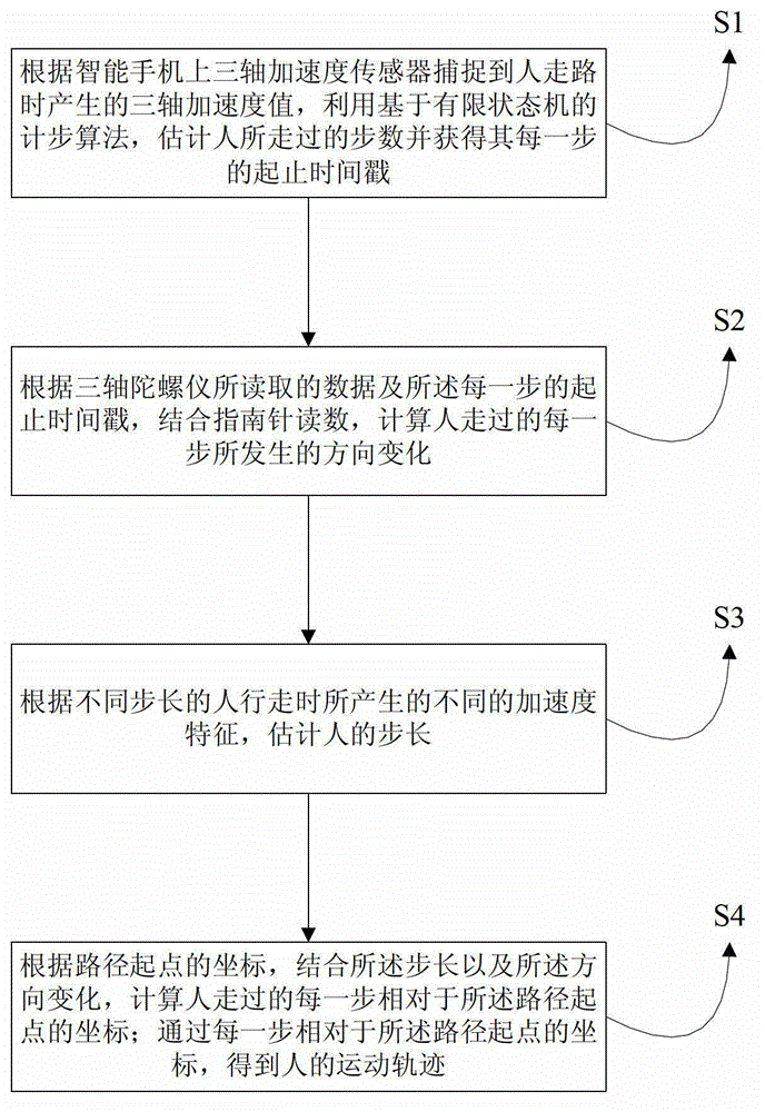
[0059] Such as figure 1 As shown, the present invention provides a smart phone-based inertial navigation method, comprising the following steps:

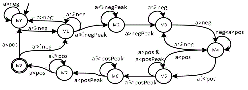
[0060] S1. According to the three-axis acceleration value captured by the three-axis acceleration sensor on the smartphone when a person walks, use the pedometer algorithm based on the finite state machine to estimate the number of steps the person has taken and obtain the start and end timestamps of each step;

[0061] S2. According to the data read by the three-axis gyroscope and the start and end time stamps of each step, combined with the compass readings, calculate the direction change of each step that the person walks;

[0062] S3. Estimate the step length of the person according to the different acceleration characteristics generated when peo...


PUM


Abstract

The invention, relating to the field of wireless positioning and inertial navigation, provides an inertial navigation system based on a smart phone and a method thereof. The method is characterized by designing a step count algorithm based on a limit state machine to calculate the steps of a person and acquire the beginning and ending time stamps of each step, and calculating the direction change of each step of the person according to the data read by a three-axis gyroscope and the beginning and ending time stamps of each step; according to different accelerated speeds generated by people having different step sizes, estimating the step size of the person; then according to the coordinate of the starting point of the path and by combining the step size and the direction change, calculating the coordinate of each step relative to the starting point of the path; and acquiring the movement track of the person by the coordinate of each step relative to the starting point of the path. According to the invention, high precision of inertial navigation can be achieved with no need for a high precision expensive inertia sensor, the accuracy is high, the practicality is strong, the versatility is wide, and the cost is low.

Description

technical field [0001] The invention relates to the fields of wireless positioning and inertial navigation, in particular to an inertial navigation system and method based on a smart phone. Background technique [0002] Inertial navigation is a technology that uses inertial sensors to achieve navigation and positioning. Mobile phone inertial navigation relies on low-precision, low-cost built-in sensors on smartphones to realize location-based services on smartphones. Because mobile phones are naturally bound to people, mobile phone inertial navigation is also usually used to estimate people's movement trajectories and provide navigation and positioning services for people. Currently the most commonly used mobile phone inertial navigation technology uses the built-in accelerometer on the mobile phone to count steps and multiply it by a specific step size to estimate the displacement; the compass or gyroscope is used to estimate the direction of movement. Theoretically speaki...

Claims


Application Information

Patent Timeline
Patent Type & Authority Applications(China)
IPC IPC(8): G01C21/16G01C21/20
Inventor 刘云浩吴陈沭杨峥
Owner TSINGHUA UNIV
Why Eureka
Try Eureka