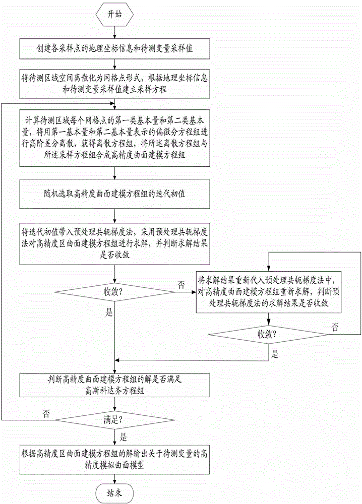
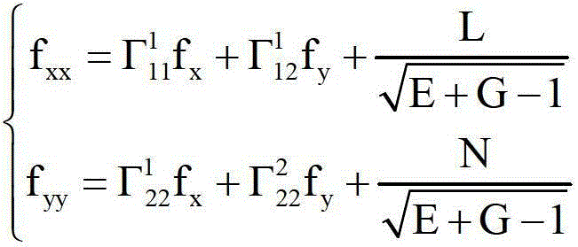
Intelligent method and device for high-precision surface modeling
A surface modeling, high-precision technology, applied in the field of surface modeling, can solve problems such as difficult to judge the surface, low precision, poor interpolation effect, etc., to achieve the effect of solving boundary oscillation, improving interpolation accuracy, and improving model accuracy
- Summary
- Abstract
- Description
- Claims
- Application Information
AI Technical Summary
Problems solved by technology
Method used
Image
Examples
Embodiment 1
[0060] my country has a vast area of plateaus, deserts, and sea-land junctions, the simulation, surface vegetation, and soil types are very complex, and the climate regional characteristics are obvious. The simulation of the Qinghai-Tibet Plateau is complex, with great differences in elevation, and there are various types of regional climates from frigid to subtropical. The plateau has an important impact on climate change in my country; The airflow is difficult to reach, and this area is one of the driest areas in the world; the eastern part of my country has a typical East Asian monsoon climate, with more precipitation. The distribution of precipitation in my country has obvious regional and seasonal characteristics. Precipitation does not show a linear relationship with the increase of altitude, and due to the influence of other factors, the relationship between precipitation and longitude and latitude is also uncertain.
[0061] For the simulation of precipitation, there...
Embodiment 2
[0098] The difference between embodiment 2 and embodiment 1 is that an intelligent device for high-precision surface modeling is adopted, including a creation module 1, a discrete establishment module 2, a discrete calculation module 3, a random selection module 4, and a solution module 5 and a judgment module 6;
[0099] The creation module 1 is used to create geographic coordinate information and sampled values of variables to be measured for each sampling point, the geographic coordinate information including the longitude information of the sampling point and the latitude information of the sampling point;
[0100] The discrete establishment module 2 discretizes the space of the area to be measured into a grid point form, and establishes a sampling equation according to the geographical coordinate information and the sampling value of the variable to be measured, and the sampling equation is used to determine whether the sampling point is on the grid point;
[0101] The ...
PUM
 Abstract
Description
Claims
Application Information
 - R&D
- Intellectual Property
- Life Sciences
- Materials
- Tech Scout
- Unparalleled Data Quality
- Higher Quality Content
- 60% Fewer Hallucinations
Browse by: Latest US Patents, China's latest patents, Technical Efficacy Thesaurus, Application Domain, Technology Topic, Popular Technical Reports.
© 2025 PatSnap. All rights reserved.Legal|Privacy policy|Modern Slavery Act Transparency Statement|Sitemap|About US| Contact US: help@patsnap.com


