
Method for highly fine three-dimensional modeling of complex earth surface

A complex surface and three-dimensional modeling technology, applied in the field of high-precision complex three-dimensional modeling, can solve the problems of complex data interface program, low modeling efficiency, poor modeling precision, etc., to simplify the modeling process, modeling The effect of high precision and improved modeling efficiency

Inactive Publication Date: 2013-06-12
HEBEI IRON & STEEL GRP MINING +2
View PDF2 Cites 15 Cited by
  • Summary
  • Abstract
  • Description
  • Claims
  • Application Information

AI Technical Summary

Problems solved by technology

However, the above methods have obvious shortcomings and deficiencies: (1) One of the keys to the accuracy of the numerical simulation calculation results is whether the constructed numerical calculation model matches the actual model; the simplification or equivalent of the complex surface greatly affects the modeling The accuracy of the modeling is poor, which affects the accuracy of the numerical calculation
(2) A more complex 3

Method used


Image

  • Method for highly fine three-dimensional modeling of complex earth surface

Examples


Embodiment Construction

[0014] The present invention will be further described below through embodiment.

[0015] In the embodiment, a large-scale open-pit mining of an iron mine began in 1975, and the development and construction of underground resources began in July 2001. The open-pit mining gradually ended, forming an open pit about 2.5 km long from north to south. After underground mining began, it was used as a dump site. After years of discharge, the open pits in the southern area have been basically filled up, while the open pits in the northern area have also undergone major changes. The surface conditions are more complicated, which has caused great difficulties in the construction of numerical models in scientific research.

[0016] The specific implementation process and parameters of this embodiment are:

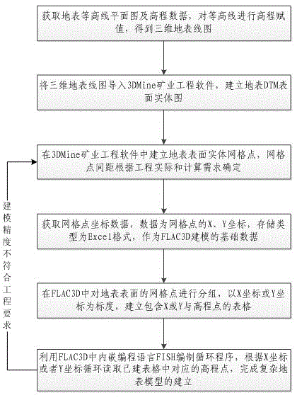
[0017] (1) Measure the surface, obtain surface elevation data and draw surface contour maps;

[0018] (2) Import CAD software, assign elevations to contour lines, and establish a thr...


PUM


Abstract

The method relates to a method for the highly fine three-dimensional modeling of complex earth surface, belonging to the technical field of analogue computation of rock-soil values. The technical scheme is that the method comprises the following steps of (1) obtaining an earth surface contour map and elevation data and establishing a three-dimensional earth surface wireframe; (2) importing the earth surface contour map and elevation data and the three-dimensional earth surface wireframe into 3DMine (Three-dimensional Mine) mineral engineering design software to build an earth surface solid model; (3) dividing earth surface grid points according to actual engineering demands to obtain grid point coordinate data; (4) exporting the grid point coordinate data and grouping and listing the grid point coordinate data in FLAC3D (Fast Lagrangian Analysis of Continua 3D); and (5) formulating a circulation program by utilizing a programming language FISH (Fluorescence In Situ Hybridization) embedded in the FLAC3D, reading a grid point coordinate data list and build an earth surface model. The method for the highly fine three-dimensional modeling of the complex earth surface has the advantages and effects that the self modeling function of the FLAC3D software is fully utilized, the simple practical modeling program is formulated through the utilization of the FISH language, the modeling procedure is simplified greatly, the modeling efficiency is improved, the modeling precision can be flexibly adjusted according to the actual engineering situation and the modeling fineness is high.

Description

technical field [0001] The invention relates to a high-precision and complex three-dimensional modeling method of the ground surface, which belongs to the technical field of rock and soil numerical simulation calculation. Background technique [0002] At present, with the rapid development of computer computing technology, more and more computers are used in the field of geotechnical engineering, and various numerical simulation software has gained a broad application space, especially the Flac series software, with its powerful computing power Become the most important geotechnical numerical simulation software at present. The computing power of FLAC series software is very outstanding, but the modeling ability is insufficient, especially for the construction of complex surface. Background technology mainly adopts two methods to solve the problem. One is to use other software to construct complex models, and then write data interfaces to import the models into FLAC for sub...

Claims


Application Information

Patent Timeline
IPC IPC(8): G06T17/05G06F17/50
Inventor 南世卿宋卫东
Owner HEBEI IRON & STEEL GRP MINING
Learn More