Combined estimation method of pulsar navigation position and speed

A technology of pulsar navigation and joint estimation, which is applied in the field of spacecraft navigation, can solve problems such as large amount of calculation, and achieve the effect of high positioning and constant speed accuracy and reduced calculation amount

Inactive Publication Date: 2013-07-24
WUHAN UNIV OF SCI & TECH
View PDF2 Cites 16 Cited by
  • Summary
  • Abstract
  • Description
  • Claims
  • Application Information

AI Technical Summary

Problems solved by technology

[0005] The present invention aims at the defect that the existing pulsar navigation positioning and speed determination methods have a large amoun...

Method used


Image

  • Combined estimation method of pulsar navigation position and speed
  • Combined estimation method of pulsar navigation position and speed
  • Combined estimation method of pulsar navigation position and speed

Examples


Embodiment Construction

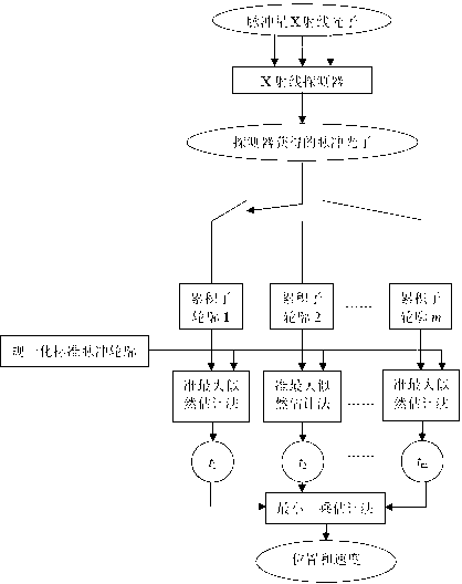
[0024] The technical solution of the present invention will be described in detail below in conjunction with the drawings and embodiments. The technical scheme can adopt computer software technology to automatically run the process.

[0025] The embodiment uses the Crab Nebula pulsar as a navigation pulsar, see figure 1 , the process of the embodiment includes the following steps:

[0026] Step 1: The embodiment uses an X-ray detector to collect pulsar X-ray photons, and the observation time interval corresponding to the pulse photon sequence obtained by the detector is segmented in the following manner. Total observation time interval (t 0 , t f ) is divided into m equal observation subintervals (t 0 +(i-1)T obs / m,t 0 +i·T obs / m), i=1,2...m, where, t 0 is the observation start time, t f is the observation end time, and the observation time is T obs =t f t 0 . Set t in the embodiment 0 =0s,t f =300s, m=30.

[0027] The value of m needs to satisfy Among them...


PUM


Abstract

The invention relates to a combined estimation method of pulsar navigation position and speed. The invention belongs to the field of spacecraft autonomous navigation. According to the method, an observation interval is divided into a plurality of sub-intervals; in each observation sub-interval, pulse signals are superimposed according to a pulsar radiation period, such that a pulse accumulation sub-contour is obtained; the pulse accumulation sub-contour is processed with a quasi-maximum likelihood estimation method, such that a pulse arrival time of each sub-interval is obtained; and according to the pulse arrival times, spacecraft position and speed are estimated with a least square estimation method. The method provided by the invention provides high-precision positioning and speed determination, which are close to those of Cramer-Rao lower bound. Also, a computation amount is low. Therefore, the method provided by the invention has important practical significance upon spacecraft autonomous navigation based on pulsar.

Description

technical field [0001] The invention belongs to the field of spacecraft navigation, in particular to a joint estimation method for pulsar navigation position and velocity. Background technique [0002] In recent years, in order to compete for space resources, space powers have launched deep space exploration activities, and accurate navigation and positioning are the premise and foundation of all deep space exploration activities. At present, spacecraft navigation systems mainly include the following types: ground station navigation system, Global Positioning System (Global Position System, GPS), gravity navigation system, geomagnetic navigation system, and celestial navigation system (Celestial Navigation System, CNS). However, these technologies are not suitable for deep space exploration. The main problems are as follows: ground station navigation systems, GPS, gravity navigation systems and geomagnetic navigation systems can only provide navigation information for aircra...

Claims


Application Information

Patent Timeline
IPC IPC(8): G01C21/24
Inventor 刘劲吴谨孙永明熊凌李娟
Owner WUHAN UNIV OF SCI & TECH
Why Eureka
Try Eureka