Method for detecting submerged mangrove forest distribution in high tide by facing object classification method and based on remote sensing satellite image

An object-oriented, remote sensing satellite technology, applied in image analysis, image data processing, instruments, etc., can solve the problem that remote sensing technology cannot accurately detect, achieve the effect of fast and effective extraction, and improve accuracy and reliability

Inactive Publication Date: 2013-07-24
NORTHEAST INST OF GEOGRAPHY & AGRIECOLOGY C A S
View PDF0 Cites 9 Cited by
  • Summary
  • Abstract
  • Description
  • Claims
  • Application Information

AI Technical Summary

Problems solved by technology

[0004] In order to solve the problem that the existing remote sensing technology cannot accurately detect the distribution of mangroves submerged under the water surface at high tide, the present invention provides a method for detecting the distribution of mangroves submerged at high tide based on remote sensing satellite images and object-oriented classification

Method used


Image

  • Method for detecting submerged mangrove forest distribution in high tide by facing object classification method and based on remote sensing satellite image
  • Method for detecting submerged mangrove forest distribution in high tide by facing object classification method and based on remote sensing satellite image
  • Method for detecting submerged mangrove forest distribution in high tide by facing object classification method and based on remote sensing satellite image

Examples


specific Embodiment approach 1

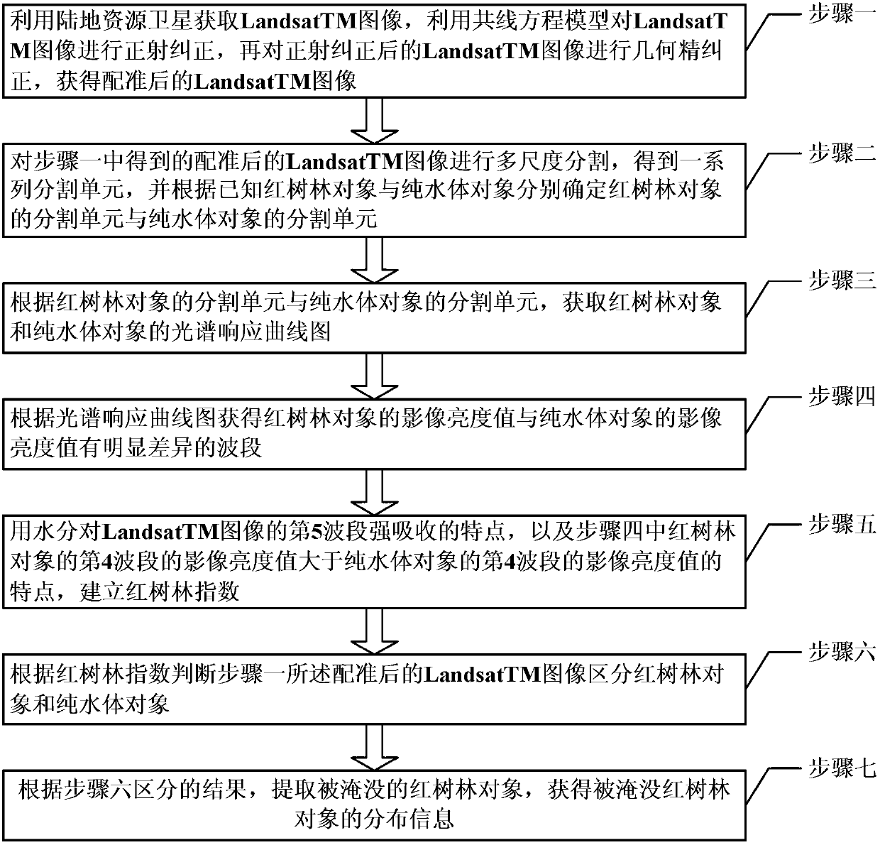
[0018] Specific implementation mode 1. Combination figure 1 and figure 2 This specific embodiment will be described. A method for detecting the distribution of submerged mangroves during high tide based on remote sensing satellite images and object-oriented classification, it includes the following steps:

[0019] Step 1: Obtain LandsatTM images using Landsat, use the collinear equation model to perform orthorectification on the LandsatTM images, and then perform geometric fine correction on the orthorectified LandsatTM images to obtain the registered LandsatTM images;

[0020] The geometric fine correction is a double-line interpolation geometric fine correction;

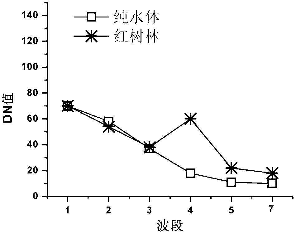
[0021] Step 2: Carry out multi-scale segmentation on the registered LandsatTM image obtained in step 1 to obtain a series of segmentation units, and determine the segmentation units of mangrove objects and pure water bodies respectively according to the known mangrove objects and pure water objects object segme...

specific Embodiment approach 2

[0029] Embodiment 2. The difference between this embodiment and Embodiment 1 is that Step 2: the process of multi-scale segmentation of the registered LandsatTM image obtained in Step 1 is:

[0030] Step 2 1: Quartering the registered LandsatTM images without overlapping to obtain R i , where i=1, 2, 3, 4;

[0031] Step 2 2: Judging the consistency of tone and texture of the internal pixels in the equally divided area, and splitting when the consistency is below 85%;

[0032] The splitting process is to divide the equally divided regions into four equal parts that do not overlap;

[0033] Step 2 3: Judging the consistency of the tone and texture of the internal pixels in adjacent equally divided areas, when the consistency is greater than or equal to 85%, the merging process is performed;

[0034] Both the splitting process and the merging process are continued until there are no equally divided regions that can be split and merged, that is, the internal consistency of the s...

specific Embodiment

[0041]Step 1: Download the medium-resolution remote sensing image LandsatTM data, the track number is P124R45, the time is October 30, 2006, the tide level is 187cm, and a large part of the mangroves in the image have been submerged by the tide. The collinear equation model is used to perform orthorectification on the LandsatTM data of the medium-resolution remote sensing image, and then use the 1:50000 terrain data to select the ground control points in the ERDAS software, and perform geometric fine correction on the orthorectified image to obtain the registration LandsatTM image after;

[0042] Step 2: Carry out multi-layer and multi-scale segmentation on the registered LandsatTM image obtained in step 1 to obtain a series of segmentation units. Each segmentation unit is composed of spatially adjacent pixels with a homogeneity of more than 85%. Treat each segmentation unit as an object;

[0043] Step 3: Utilize object-oriented classification software to directly extract the...


PUM


Abstract

The invention discloses a method for detecting submerged mangrove forest distribution in high tide by facing an object classification method and based on a remote sensing satellite image and relates to a method of utilizing remote sensing technology to detect mangrove forests below a water surface in the high tide. The method solves the problem that existing remote sensing technology can not accurately detect and obtain the distribution of the mangrove forests submerged below the water surface in the high tide. The method comprises the following steps of utilizing a land resource satellite to obtain a Landsat TM image, and obtaining the Landsat TM image after rectification; conducting multi-scale segmentation on the image after rectification, obtaining a series of segmentation units, and confirming segmentation units of a mangrove forest object and segmentation units of a pure water body object; obtaining spectrum response curve graphs of the mangrove forest object and the pure water body object; building a mangrove forest index; according to the mangrove forest index MVI, judging the Landsat TM image after rectification in the step one to distinguish the mangrove forest object and the pure water body object; and extracting the submerged mangrove forest object, and obtaining distribution information of the submerged mangrove forest object. The method can be widely applied to judgment of the mangrove forest distribution situation in the high tide.

Description

technical field [0001] The invention relates to a method for detecting mangroves below the water surface at high tide by using remote sensing technology. Background technique [0002] Mangroves have great economic, social, and ecological values. They can protect against wind and embankments, stabilize coastlines, purify water, and provide local residents with important forest products and social services. It plays a particularly important role in maintaining marine biodiversity, developing ecotourism, conducting scientific research, maintaining ecological balance in coastal zones, and reducing disasters. It is a precious wealth bestowed by nature to human beings. Therefore, the rapid and accurate production of mangrove thematic maps is of great significance for effectively strengthening the protection and management of mangrove wetlands and ecological restoration. [0003] In recent years, remote sensing technology has become an effective method for making mangrove thematic...

Claims


Application Information

Patent Timeline
Patent Type & Authority Applications(China)
IPC IPC(8): G06T7/00
Inventor 贾明明刘殿伟王宗明汤旭光丁智董张玉
Owner NORTHEAST INST OF GEOGRAPHY & AGRIECOLOGY C A S
Why Eureka
Try Eureka