Image-processing-based unmanned plane accurate position landing method

A technology of image processing and unmanned aerial vehicles, applied in the direction of three-dimensional position/channel control, etc., can solve problems such as landing errors and insufficient GPS accuracy, and achieve the effect of improving the degree of intelligence and reducing costs

Inactive Publication Date: 2013-07-31
GUANGDONG UNIV OF TECH
View PDF6 Cites 120 Cited by
  • Summary
  • Abstract
  • Description
  • Claims
  • Application Information

AI Technical Summary

Problems solved by technology

[0003] In order to solve the defect of landing errors caused by insufficient GPS accuracy in the prior art, and improve the intelligence of UAV control, the present invention proposes an image processing-based UAV precise position landing method

Method used


Image

  • Image-processing-based unmanned plane accurate position landing method
  • Image-processing-based unmanned plane accurate position landing method
  • Image-processing-based unmanned plane accurate position landing method

Examples


Embodiment Construction

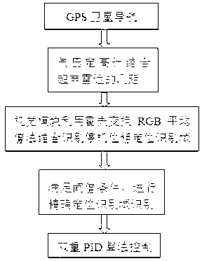
[0030] An image processing-based method for landing a UAV at a precise position according to the present invention will be further described in detail below in conjunction with the accompanying drawings.

[0031] Step 1: The GPS satellite navigation system puts the UAV over the ground apron, and the GPS satellite positioning system navigates the UAV over the apron.

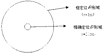
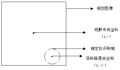
[0032] The above-ground apron, such as figure 2 As shown, the landing position of the marked UAV is marked by two concentric circles with radii of 20cm and 1m respectively. The inner circle is the precise positioning recognition domain, and the area between the outer circle and the inner circle is the rough positioning recognition domain, which are respectively marked in green and red. Filling, that is, the precise positioning identification domain is filled with green, the coarse positioning identification domain is filled with red, and the center of the concentric circle is the precise position of the landing p...


PUM


Abstract

The invention discloses an image-processing-based unmanned plane accurate position landing method, which comprises the following steps: (1) a GPS (global position system) satellite navigation system enables an unmanned plane to be located above a ground parking apron; (2) an air pressure height measurement gauge and a distance measurement module of an ultrasound radar are combined to control the ground clearance for the unmanned plane to land; (3) a vision module identifies a coarse positioning identification domain in real time, and combines Hough Transform and RGB mean value method and gate position identification to process a coordinate of a targeted landing point; (4) when landing of the unmanned plane meets the threshold condition of the coarse positioning identification domain, the algorithm in the step (3) is utilized to perform accurate positioning treatment on the accurate positioning identification domain; and (5) the unmanned plane is controlled for accurate landing by taking the treated deviation value as the input quantity and adopting the double PID algorithm. According to the invention, the defect that insufficient GPS accuracy of the unmanned plane causes a fault landing is overcome, the intelligence for the unmanned plane control is improved, and the cost for using an accurate sensor is greatly reduced.

Description

technical field [0001] The invention relates to the field of unmanned aerial vehicle control, more specifically, to an image processing-based method for landing an unmanned helicopter at a precise position. Background technique [0002] Unmanned aerial vehicle (UAV) autonomous flight technology has been a research hotspot in the field of aviation for many years. It has the advantages of convenient use, low operating cost, high flight accuracy, flexible maneuverability and easy intelligence, and there are a lot of demands in practical applications, such as : Reconnaissance and rescue missions, scientific data collection, geological and forestry exploration, agricultural pest control, video surveillance, film and television production, etc. Unmanned helicopters have the advantages of not needing special take-off and landing sites and runways, can take off and land vertically, and require very little space, and have attracted more attention in recent years. On May 7, 2011, the...

Claims


Application Information

Patent Timeline
Patent Type & Authority Applications(China)
IPC IPC(8): G05D1/10
Inventor 柯宗泽苏成悦李欣怡刘柏芳邹志明
Owner GUANGDONG UNIV OF TECH
Why Eureka
Try Eureka