Method for acquiring access time window for shooting and imaging ground target area by satellite

A ground target and access time technology, applied in the field of remote sensing satellite imaging, can solve the problems of low computing efficiency, low efficiency, and restricting the rapid response ability of remote sensing satellite imaging technology to emergencies, etc.

Active Publication Date: 2013-09-04
INST OF REMOTE SENSING & DIGITAL EARTH CHINESE ACADEMY OF SCI
View PDF4 Cites 19 Cited by
  • Summary
  • Abstract
  • Description
  • Claims
  • Application Information

AI Technical Summary

Problems solved by technology

[0009] It can be seen from the traditional traversal calculation method above that although the traditional traversal calculation method can obtain the imaging access time window of the satellite to the ground target area, the traditional traversal calculation method has the disadvantages of large amount of calculation and low calculation efficiency, especia

Method used


Image

  • Method for acquiring access time window for shooting and imaging ground target area by satellite
  • Method for acquiring access time window for shooting and imaging ground target area by satellite
  • Method for acquiring access time window for shooting and imaging ground target area by satellite

Examples


Embodiment

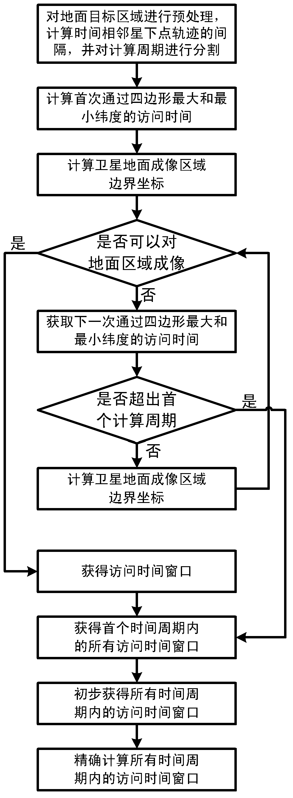
[0102] Take the HJ-1A satellite as an example, choose the CCD sensor carried by the HJ-1A satellite, the ground target area is a quadrilateral, and the longitude and latitude coordinates of the corner points of the ground target area are: (110E, 36N), (113E, 36N), (113E, 33N ), (110E, 33N). HJ-1A satellite return period T b for 31 days. HJ-1A satellite orbit period T c for 97.65 minutes.

[0103] The start time of HJ-1A satellite's imaging visit to the ground target area is 0:00:00 on January 1, 2013, Beijing time. Divided into 6 calculation periods, the first calculation period ends at 0:00:00 on January 4, 2013, and lasts for 3 days; the second calculation period ends at 0:00 on January 8, 2013 0 seconds, lasted 7 days; the end time of the third calculation period is 0:00:00 on January 16, 2013, which lasted 15 days; the end time of the fourth calculation period is 0:00 on February 1, 2013 0 seconds, which lasted 31 days; the fifth calculation cycle ended at 0:00:00 on ...


PUM


Abstract

The invention discloses a method for acquiring an access time window for shooting and imaging a ground target area by a satellite. The method comprises the steps that pretreatment is conducted on the ground target area, the interval of tracks of time-adjacent subsatellite points is calculated, and a calculating period is divided; the access time window for shooting and imaging the ground target area by the satellite in a first time period is calculated; the access time windows for shooting and imaging the ground target area by the satellite in all time periods are primarily calculated; the primarily calculated access time windows for shooting and imaging the ground target area by the satellite in all the time periods are optimized to precisely obtain the access time window for shooting and imaging the ground target area by the satellite in all the time periods. The method is used, the access time window for shooting and imaging the ground target area by a remote sensing satellite can be quickly acquired, the efficiency for acquiring the access time window for imaging the ground target area by the remote sensing satellite can be improved, and the quick response capacity to emergencies of a remote sensing satellite imaging technology is improved.

Description

technical field [0001] The invention relates to the technical field of remote sensing satellite imaging, in particular to a method for obtaining an access time window in which a satellite can photograph and image a ground target area. Background technique [0002] The access time window for the satellite to image the ground target area, that is, the start time and end time for the satellite to image the ground target area, is an important parameter in the field of remote sensing satellite imaging technology for the satellite to image the ground target area. Characterize the time period during which the satellite can image the ground target area. [0003] With the continuous development of remote sensing satellite technology, remote sensing satellite technology is playing an increasingly important role in disaster monitoring, resource investigation, surveying and mapping, agricultural production estimation, environmental protection and other application fields. How to quickly...

Claims


Application Information

Patent Timeline
IPC IPC(8): H04B10/118
Inventor 马广彬黄鹏章文毅冯柯过西荣贾秀鹏厉为梅怀博韩琼高佳佳王志信曹平罗伏军李程
Owner INST OF REMOTE SENSING & DIGITAL EARTH CHINESE ACADEMY OF SCI
Why Eureka
Try Eureka