Three-dimensional locator and method

A three-dimensional locator and current position technology, applied in the field of three-dimensional locator, can solve the problem of inability to accurately derive the current position of the vehicle, and achieve the effect of improving service satisfaction

Active Publication Date: 2017-07-28
HYUNDAI MOBIS CO LTD
View PDF6 Cites 0 Cited by
  • Summary
  • Abstract
  • Description
  • Claims
  • Application Information

AI Technical Summary

Problems solved by technology

[0006] As mentioned above, the traditional navigator cannot accurately derive the current position of the vehicle if the vehicle is near an elevated road, underground road, construction parking lot, or underground parking lot during "map matching"

Method used


Image

  • Three-dimensional locator and method
  • Three-dimensional locator and method
  • Three-dimensional locator and method

Examples


Embodiment Construction

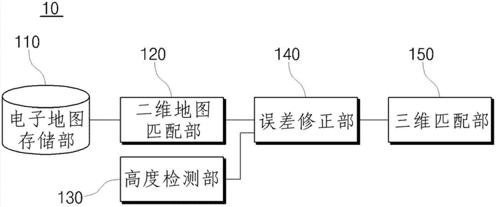
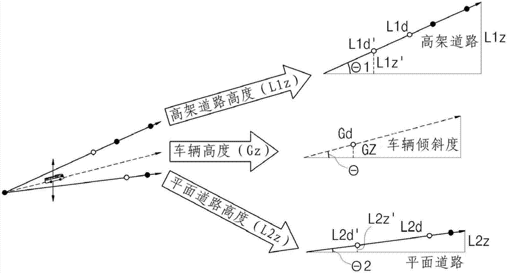
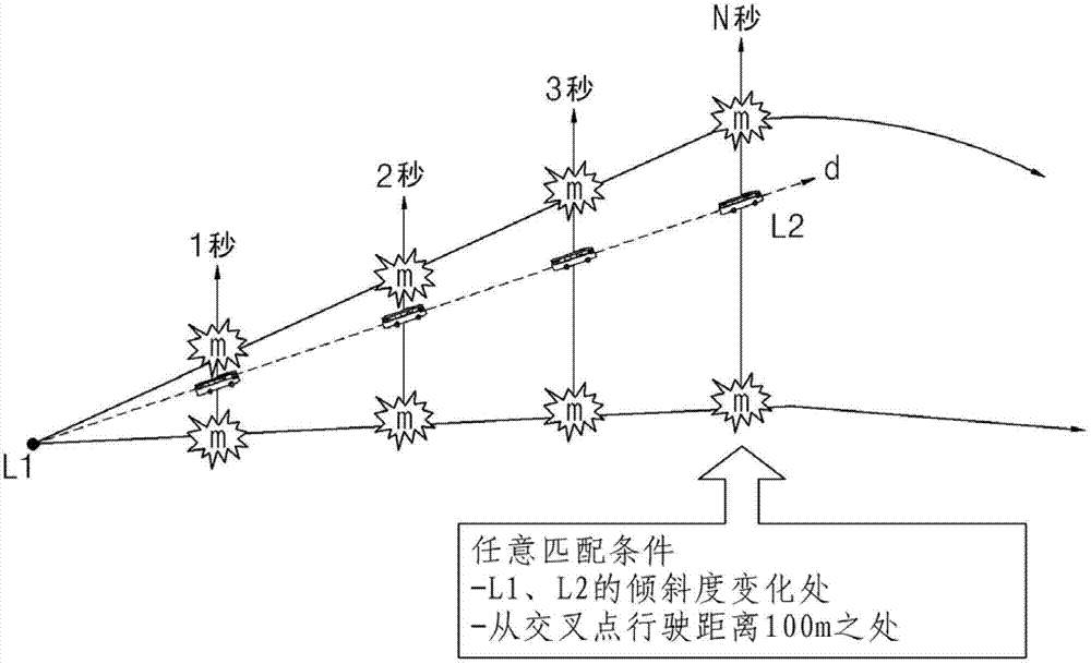
[0016] The present invention will be further described below in conjunction with the accompanying drawings and specific embodiments, so that those skilled in the art can better understand the present invention and implement it, but the examples given are not intended to limit the present invention.

[0017] In order to make the purpose, technical solutions and advantages of the embodiments of the present invention more clear, the technical solutions in the embodiments of the present invention will be clearly and completely described below in conjunction with the drawings in the embodiments of the present invention. Apparently, the described embodiments are some, but not all, embodiments of the present invention. Based on the embodiments of the present invention, all other embodiments obtained by persons of ordinary skill in the art without making creative efforts belong to the protection scope of the present invention. The terms used in the present invention are only used to d...


PUM


Abstract

The invention discloses a three-dimensional locator and a method. The three-dimensional locator includes: an electronic map storage unit, which stores an electronic map including two-dimensional position information and height information of a plurality of interpolation points; a map matching unit, which selects at least one candidate road; The height detection unit calculates the relative height of the vehicle corresponding to the plurality of interpolation point units; the error correction unit calculates the at least one candidate road corresponding to the current position of the point between the previous interpolation point and the current position. The three-dimensional matching part confirms whether the difference between the relative heights of the vehicle is within the set critical error, and selects a candidate road within the critical error from the at least one candidate road to implement a map for the current position match. The present invention improves map matching accuracy on elevated roads, underground roads, construction parking lots and other roads with a height difference from flat roads, thereby introducing routes more accurately and bringing more convenience to drivers.

Description

technical field [0001] The invention relates to three-dimensional map matching, in particular to a three-dimensional locator and method capable of improving the accuracy of three-dimensional terrain matching. Background technique [0002] Navigators generally use GPS, vehicle speed and gyroscope sensors to grasp the current position of the vehicle, and provide the driver with the current position of the vehicle and map data. [0003] GPS signals are generally divided into SPS (Standard Positioning System) for civil purposes and PPS (Precise Positioning System) for military purposes. However, the navigator uses SPS with an error range within 200m, and corrects the SPS error through "map matching". [0004] With conventional navigators, if the vehicle's position calculated from the GPS signal is not the road, the vehicle's position is corrected to the road by "map matching" that takes into account factors such as the vehicle's previous position or moving speed. [0005] Howe...

Claims


Application Information

Patent Timeline
Patent Type & Authority Patents(China)
IPC IPC(8): G01C21/30
CPCG01C21/10G01C21/30G01S19/13
Inventor 金范祚
Owner HYUNDAI MOBIS CO LTD
Why Eureka
Try Eureka