Geotechnical engineering investigation method

A technology of geotechnical engineering and engineering, applied in the field of geotechnical engineering investigation, to achieve the effect of wide application prospect, simple steps and high investigation accuracy

Active Publication Date: 2013-10-02
FUZHOU PLANNING DESIGN & RES INST
View PDF4 Cites 7 Cited by
  • Summary
  • Abstract
  • Description
  • Claims
  • Application Information

AI Technical Summary

Problems solved by technology

[0009] In order to overcome the defects of the existing engineering survey methods and realize the understanding of the continuous geological distribution information of linear projects such as pipelines and subways, the present invention designs a method for direct and accurate survey of linear projects

Method used


Image

  • Geotechnical engineering investigation method
  • Geotechnical engineering investigation method
  • Geotechnical engineering investigation method

Examples


Embodiment Construction

[0025] The present invention will be described in further detail below in conjunction with the accompanying drawings and specific embodiments.

[0026] A specific embodiment of the present invention is: a geotechnical engineering survey method, characterized in that it comprises the following steps:

[0027] (1) Divide the geotechnical survey area into several working sections along the project direction;

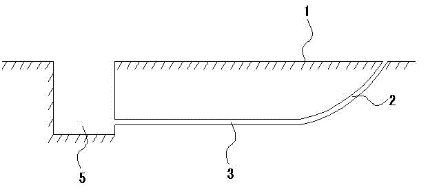
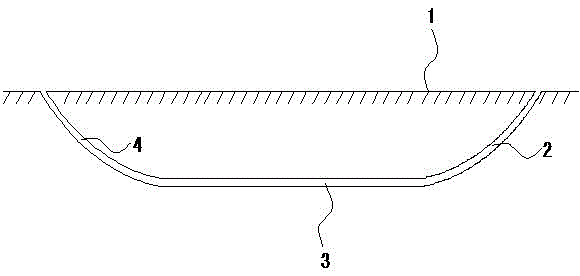
[0028] refer to figure 1 As shown, the geotechnical survey area is divided into several working sections along the engineering construction direction. The length of the working section can be hundreds of meters to several thousand meters. The starting position and ending position of horizontal directional drilling for each working section are required There is a working environment suitable for horizontal directional drilling operations, and a working pit 5 can be set between the two working sections, which is conducive to subsequent piping and information collection opera...


PUM


Abstract

A geotechnical engineering investigation method is characterized by comprising the following steps: (1) dividing a geotechnical investigation region into a plurality of working segments in the engineering strike; (2) achieving horizontal directional drilling in the tested region of each working segment, and laying a pipeline allowing an engineering physical testing device and a receiving device to pass in the engineering strike in the aperture passage; (3) repeating the step (2) and ensuring that at least two pipelines exist in the tested region; (4) placing the engineering physical testing device in one of the pipelines and the receiving device in the other pipeline, and enabling the engineering physical testing device and the receiving device to move from the same end of the pipelines to the other end so as to detect and acquire geotechnical investigation data of each region. The geotechnical engineering investigation method has simple steps and high investigation accuracy, and particularly has broad application prospect in linear engineering constructions, such as pipelines, subways and tunnels.

Description

technical field [0001] The invention relates to a geotechnical engineering investigation method. Background technique [0002] Any civil engineering is closely related to rock and soil, they directly contact and interact with the rock and soil medium. Therefore, it is an important prerequisite for engineering design and construction to fully understand and understand the distribution characteristics of rock and soil mass and engineering properties. Exploration is the main means to reveal the spatial distribution of rock and soil (including the distribution of groundwater closely related to rock and soil) and changes. [0003] The forms of various civil engineering foundations are different, some are in the shape of "points" and some are in the shape of "lines". In a typical building such as a frame structure, the structural columns disperse the gravity of the house to the foundation at a relatively independent point. At this time, it is only necessary to investigate the fo...

Claims


Application Information

Patent Timeline
IPC IPC(8): F16L1/032F16L1/06
Inventor 夏昌高学珑陈奕
Owner FUZHOU PLANNING DESIGN & RES INST
Why Eureka
Try Eureka