Novel organization method of single-scene image tile data

A tile and image technology, which is applied in the field of massive remote sensing image visualization, can solve the problem of time-consuming tile data, achieve the effect of improving reading performance, improving retrieval and reading speed, and reducing storage space

Inactive Publication Date: 2013-10-02
INST OF REMOTE SENSING & DIGITAL EARTH CHINESE ACADEMY OF SCI
View PDF3 Cites 23 Cited by
  • Summary
  • Abstract
  • Description
  • Claims
  • Application Information

AI Technical Summary

Problems solved by technology

[0006] Aiming at the time-consuming problem of reading tile data of a single scene image in the real-time dynamic rendering of massive remote sensing images, the present invention provides a new organization method of tile data of a single scene image, especially focusing on the tile data of a single scene image continuous storage of tile data, avoiding resampling of images when reading tile data and reducing random jumps in data reading positions, improving tile data reading efficiency, thereby greatly reducing the time consumption of map tile rendering and ensuring massive Real-time dynamic rendering of data

Method used


Image

  • Novel organization method of single-scene image tile data
  • Novel organization method of single-scene image tile data
  • Novel organization method of single-scene image tile data

Examples


Embodiment Construction

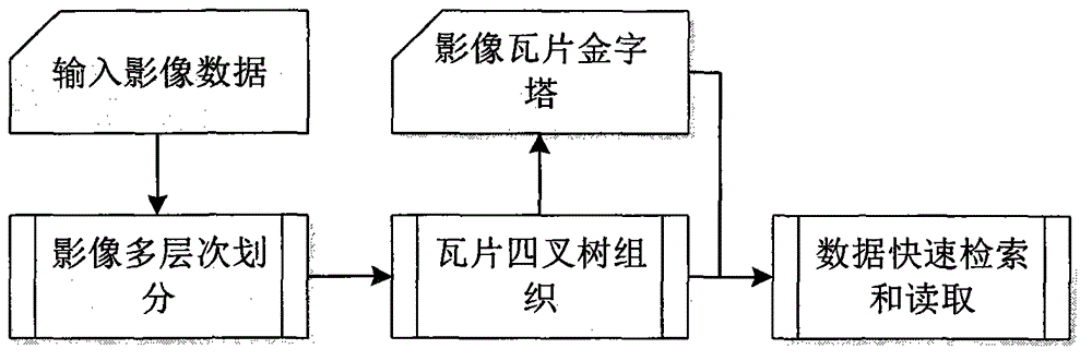
[0027] figure 1 It shows the organization and reading process of the tile data of a single scene image. It mainly includes three parts: (1) multi-level division of single scene image, (2) quadtree organization of tile data, (3) fast reading of tile data.

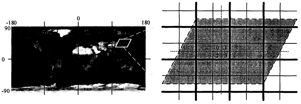
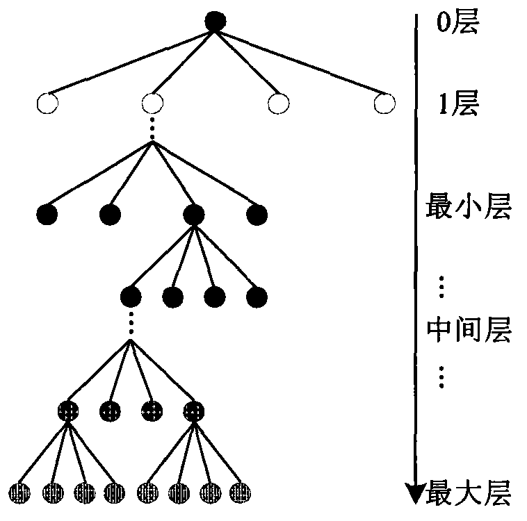
[0028] figure 2 It is a schematic diagram of the division of the geographic range of the image by the global geographic reference grid. The global geographic reference grid can adopt the latitude and longitude grid and the Web Mercator grid. The present invention takes the latitude and longitude grid as an example to specifically introduce the implementation process. The standard longitude-latitude grid divides the global geographical range (longitude [-180~180], latitude [90~-90]) with 256*256 square tiles, forming a 0-layer grid with 4 blocks in the longitude direction and 2 blocks in the latitudinal direction. In this division method, 8 tile root nodes are generated at layer 0; in theory, a sufficiently large image wi...


PUM


Abstract

The invention provides a novel organization mode of single-scene image tile data. Particularly, emphasis is laid on storing each tile data continuously, resampling to image data and randomness of a data reading position in a reading process of the tile data are reduced, and the reading efficiency of the tile data is improved, so that time consumption of map tilt rendering is reduced greatly, and real-time dynamic rendering of mass data is ensured. The organization mode comprises the steps of selecting a global geographical reference grid multilevel-division single-scene image, constructing a quadtree storage structure of the image tile data, reading the image data (retaining primitive attributes such as the band number of the data, and bit depth) within a geographical range of tiles for each division tile, forming the complete and continuous tile data, compressing and storing the tile data in a hard disk file, adopting the multilevel tile data of a quadtree structure organization image, and ensuring efficient retrieval and reading of the tile data.

Description

technical field [0001] The invention belongs to the technical field of visualization of massive remote sensing images, and in particular relates to a new method for organizing single-scene image tile data. Dynamic rendering. Background technique [0002] At present, the map tile data organization method based on the pre-generation idea is an important technical means to improve the response speed of image visualization in mainstream 3D GIS software (such as Google Earth, World Wind, Skyline and GeoGlobe, etc.). The key is that the image visualization server preprocesses the massive image data to be displayed, generates multi-level map tiles covering the global surface, and stores them in quadtree structures or hierarchical folders; when the visualization server receives the client map tiles When requested, the corresponding tile data can be quickly retrieved and read to achieve a fast response. However, this method of pre-generating global map tiles seriously reduces the f...

Claims


Application Information

Patent Timeline
Patent Type & Authority Applications(China)
IPC IPC(8): G06F17/30
Inventor 周亚男骆剑承胡晓东郜丽静沈占锋王伟胜
Owner INST OF REMOTE SENSING & DIGITAL EARTH CHINESE ACADEMY OF SCI
Why Eureka
Try Eureka