Polar Inertial Navigation Method Based on Horizontal Geographical Coordinate System

A geographic coordinate system and inertial navigation technology, which is applied in the field of polar inertial navigation based on the horizontal geographic coordinate system, can solve problems such as magnification, uncertain navigation of the geographic coordinate system, and inapplicability of the geographic coordinate system

Active Publication Date: 2015-10-28
SOUTHEAST UNIV
View PDF2 Cites 0 Cited by
  • Summary
  • Abstract
  • Description
  • Claims
  • Application Information

AI Technical Summary

Problems solved by technology

[0004] Purpose of the invention: The present invention aims at the problem that the geographical coordinate system cannot be used at the pole and the problem of error amplification when it is used in the area near the pole, and proposes a polar area inertial navigation method based on the horizontal geographic coordinate system. The method is based on horizontal coordinates The horizontal geographic coordinate system is used as the navigation coordinate system to solve the navigation problems caused by the inapplicability of the geographic coordinate system in polar regions
[0005] The technical scheme of the polar region inertial navigation method based on the horizontal geographic coordinate system described in the present invention is: reselect two points at the earth's equator as the horizontal poles, so that when the carrier runs at the original poles, it becomes at the horizontal equator Running, then it also solves the original navigation problem caused by the uncertainty of the geographic coordinate system at the pole

Method used


Image

  • Polar Inertial Navigation Method Based on Horizontal Geographical Coordinate System
  • Polar Inertial Navigation Method Based on Horizontal Geographical Coordinate System
  • Polar Inertial Navigation Method Based on Horizontal Geographical Coordinate System

Examples


Embodiment Construction

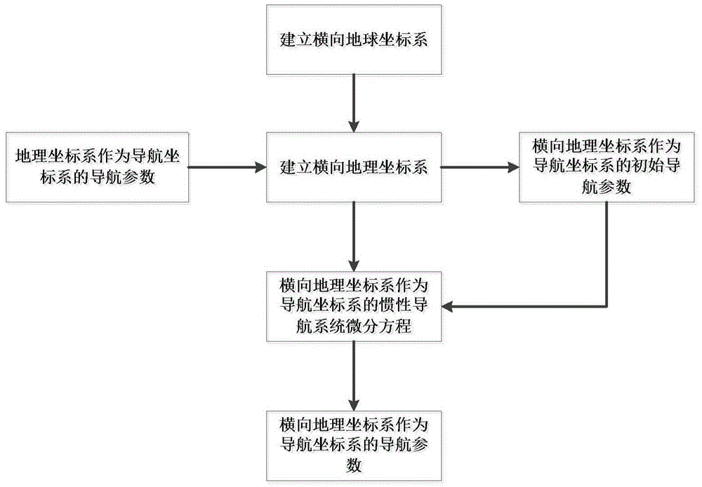
[0056] A polar area inertial navigation method based on a horizontal geographic coordinate system, the earth model is taken as a spherical shape and the radius of the sphere is R, comprising the following steps:

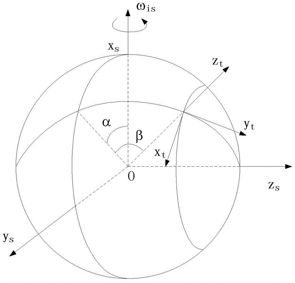
[0057] Step 1: Establish the horizontal earth coordinate system s:

[0058] The origin of the horizontal earth coordinate system s is located at the center of the earth, x s Axis passing through the North Pole, y s The axis passes through the intersection of the prime meridian and the equator, z s The axis passes through the intersection of the 90° East meridian and the equator and defines this intersection as the transverse North Pole;

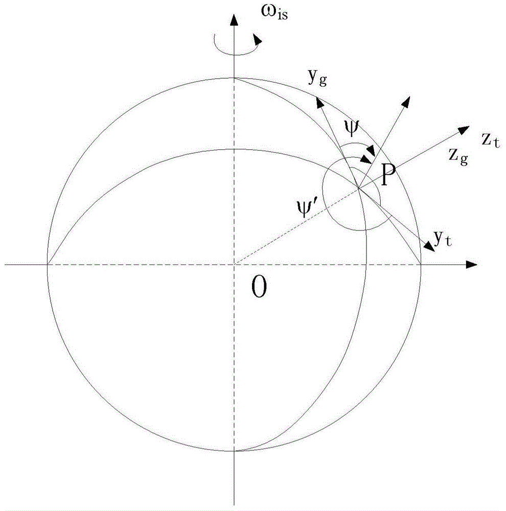
[0059] Step 2: Establish the horizontal geographic coordinate system t:

[0060] Define the horizontal geographic coordinate system t on the basis of step 1, the origin of the horizontal geographic coordinate system t is located at the center of mass of the carrier, y t The axis points to the horizontal North Pole along the tang...


PUM


Abstract

The invention discloses a polar region inertial navigation method based on a horizontal geographic coordinate system. The method includes the following steps of building a horizontal earth coordinate system and the horizontal geographic coordinate system, taking the horizontal geographic coordinate system as a navigation coordinate system of a strapdown inertial navigation system and carrying out mechanical arrangement, and providing a conversion relation between two navigation parameters of a geographic coordinate system and the horizontal geographic coordinate system so as to achieve smooth transition of a navigation mode of a carrier when the carrier operates from a non-polar region to a polar region. By means of a strapdown inertial navigation arrangement mode in the horizontal geographic coordinate system, the problem that a strapdown algorithm based on the geographic coordinate system fails due to meridian convergence in the polar region is solved.

Description

technical field [0001] The present invention mainly relates to the technical field of inertial navigation, in particular to a method of inertial navigation in polar regions based on a horizontal geographic coordinate system. Background technique [0002] The navigation coordinate system of the existing strapdown inertial system is mainly divided into a geographic coordinate system g, a local horizontal wandering coordinate system w, an earth-centered fixed coordinate system e, an inertial coordinate system i, and the like. Since the carrier is moving on the surface of the earth, the information used for carrier navigation is given in the geographic coordinate system g. If other coordinate systems are used, the calculation results should also be transformed into the geographic coordinate system. However, the north direction of the geographic coordinate system is the tangential direction of the tracking meridian. In the polar region, due to the convergence of the meridian, th...

Claims


Application Information

Patent Timeline
Patent Type & Authority Patents(China)
IPC IPC(8): G01C21/16G01C21/20
CPCG01C21/16G01C21/20
Inventor 徐晓苏豆嫚姚逸卿徐胜保吴剑飞
Owner SOUTHEAST UNIV
Why Eureka
Try Eureka