A Node Location Method for Underwater Sensor Networks

An underwater sensor and sensor node technology, applied in network topology, electrical components, wireless communication, etc., can solve problems such as inability to locate, high energy consumption super nodes, and high communication overhead.

Active Publication Date: 2016-05-25
SHANDONG COMP SCI CENTNAT SUPERCOMP CENT IN JINAN
View PDF3 Cites 0 Cited by
  • Summary
  • Abstract
  • Description
  • Claims
  • Application Information

AI Technical Summary

Problems solved by technology

[0004] 1. The coplanarity of the anchor nodes causes a large positioning error or some methods cannot be positioned, which cannot meet the actual application requirements;
[0005] 2. The system needs to deploy a large number of super nodes with high energy consumption, resulting in excessive communication overhead and shortening the network life cycle
[0006] 3. The three-dimensional positioning is transformed into two-dimensional positioning through mapping, and the easy-to-measure depth information is not fully utilized, which reduces the positioning accuracy

Method used


Image

  • A Node Location Method for Underwater Sensor Networks
  • A Node Location Method for Underwater Sensor Networks
  • A Node Location Method for Underwater Sensor Networks

Examples


Embodiment Construction

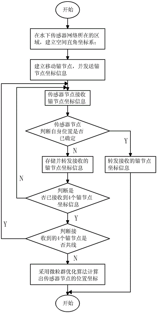
[0034] The present invention will be further described below in conjunction with the accompanying drawings and embodiments.

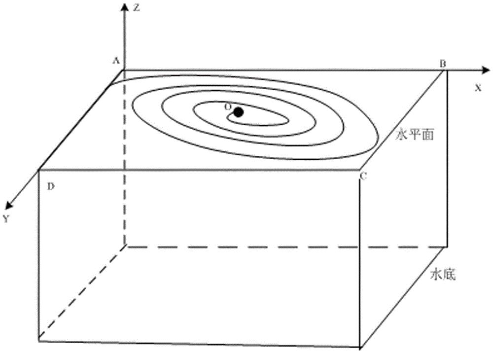
[0035] 1. Establishment of space Cartesian coordinate system

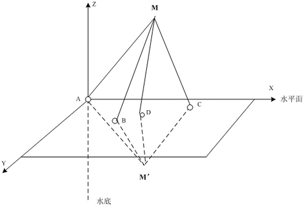
[0036] Select the center of the water surface in the area that needs to be positioned to establish a space Cartesian coordinate system. Such as figure 1 As shown in , the schematic diagram for establishing a space Cartesian coordinate system is given, assuming that the underwater positioning area is a regular cube (M*N*H), where M, N, and H are the length, width, and height of the cube, respectively, then The water surface of the positioning area is a regular rectangular area (M*N). A, B, C, and D are the vertices of the rectangle. One of the nodes A is selected as the origin. The X axis is parallel to one side AB of the rectangle, and the Y axis is parallel to the rectangle. The other side BC of , uses the horizontal plane as the XOY plane to establish a spatial Cartesian coordinate syste...


PUM


Abstract

The invention discloses a method for positioning nodes of an underwater sensor network. The method comprise the following steps: a) establishing a space rectangular coordinate system; b) establishing a moving anchor node which moves along an isometric helical line; c) broadcasting anchor node coordinate information; d) receiving the coordinate information; e) judging whether the positions are determined; f) judging whether four pieces of coordinate information are received; g) judging whether the four anchor node coordinates are collinear; h) calculating the positions. According to the method for positioning the nodes of the underwater sensor network, a sensor node can determine the coordinate of self according to the four received collinear anchor node coordinates, so that the difficulty in deploying anchor nodes of the underwater sensor network is solved, and the network deployment cost is lowered at the same time; as position information of four non-collinear anchor nodes is adopted for positioning, the method complexity is reduced, and the method is easy to realize; according to characteristics of underwater deployment of the nodes, the search space of a particle group is limited, and the positioning method efficiency is improved.

Description

technical field [0001] The present invention relates to a node positioning method of an underwater sensor network, more specifically, it relates to an anchor node performing a spiral movement on the water surface, and the sensor node performs position calculation according to four non-collinear anchor node coordinates received. The node localization method of the lower sensor network. Background technique [0002] In recent years, with the rise of the marine economy and the increasing emphasis on marine rights and interests in various countries, the underwater sensor network has made rapid progress. Now it has been widely used in many civilian applications such as ocean observation, resource exploration and development, disaster forecast, pollution detection, and military detection. and military fields. Node positioning technology is one of the key technologies of underwater sensor network. In most applications, it is necessary to quickly and effectively locate the position...

Claims


Application Information

Patent Timeline
Patent Type & Authority Patents(China)
IPC IPC(8): H04W64/00H04W84/18
Inventor 魏诺舒明雷孔祥龙周书旺刘瑞霞杨明陈长芳张重庆杨媛媛许继勇马继鹏唐梅玉
Owner SHANDONG COMP SCI CENTNAT SUPERCOMP CENT IN JINAN
Why Eureka
Try Eureka