Autonomous orbit determination method based on satellite borne processor

An autonomous orbit determination and processor technology, which is applied to satellite radio beacon positioning systems, instruments, and radio wave reflection/re-radiation. It can solve problems such as divergence of forecast ephemeris accuracy and inability to use

Active Publication Date: 2014-01-29
NAT UNIV OF DEFENSE TECH
View PDF2 Cites 28 Cited by
  • Summary
  • Abstract
  • Description
  • Claims
  • Application Information

AI Technical Summary

Problems solved by technology

Even if the navigation satellites retain the forecast ephemeris for a period of time through pre-store, if the ground station cannot regularly update the parameters, the forecast ephemeris cannot be used due to the divergence of accuracy

Method used


Image

  • Autonomous orbit determination method based on satellite borne processor
  • Autonomous orbit determination method based on satellite borne processor
  • Autonomous orbit determination method based on satellite borne processor

Examples


Embodiment Construction

[0091] The present invention will be further described in detail below in conjunction with specific embodiments and accompanying drawings.

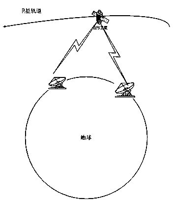
[0092] figure 1 It is a traditional navigation satellite orbit determination method based on ground station measurements.

[0093] The traditional navigation satellite orbit determination method is based on the long-term measurement of the navigation satellite by the ground station. According to the measurement results, the calculation is performed on the ground, the data is fitted and extrapolated, and finally the navigation satellite forecast orbit ephemeris is obtained, which is injected to the Navigation satellites for distributing broadcasts.

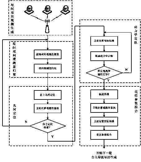
[0094] figure 2 It is the structural diagram of the navigation satellite autonomous orbit determination algorithm based on inter-satellite ranging of the present invention, and the algorithm is composed of the following implementation steps.

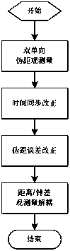
[0095] Step 1: Generation of intersatellite tw...


PUM


Abstract

The invention provides an autonomous orbit determination method based on a satellite borne processor. The method overcomes the difficulty of orbit determination precision divergency for navigation satellite orbit determination under the condition of breaking away from the support of a ground surface station by utilizing inter-satellite ranging, completes multiple steps of precise measurement data conversion among navigation satellites, reduction of different time measurement values, geometric orbit determination, dynamics orbit determination, autonomous ephemeris generation and the like, and achieves the navigation satellite autonomous orbit determination algorithm in breaking away from the support of top pouring of data of the ground surface station. The method not only has no measurement data of the ground surface station, but also has no top pouring data of the ground surface station under the condition of breaking away from the support of the ground surface station; navigation satellite only depends on the interstellar bidirectional measurement result and combines with the 60-day long-term forecast ephemeris prestored on the navigation satellite, and obtains the real-time orbit forecast result of the navigation satellite through the autonomous algorithm of the navigation satellite, and can generate broadcast ephemeris to send.

Description

technical field [0001] The invention mainly relates to an autonomous orbit determination method based on a space-borne processor. Background technique [0002] The Global Navigation Satellite System (GNSS) can provide all-weather precise position and time information for any location on the earth and near-Earth space. The global satellite navigation system can support various tactical operations that require precise position and time information. It forms a multi-arms coordinated combat command system with other systems such as communications, computers, and intelligence surveillance. It has become a support system and a multiplier for the armed forces. One of the essential core key systems in the formation of combat capabilities based on information systems. In addition, satellite navigation systems have been widely used in various fields of the national economy, not only providing a strong driving force for economic development, but also becoming an important infrastructu...

Claims


Application Information

Patent Timeline
Patent Type & Authority Applications(China)
IPC IPC(8): G01C21/24
CPCG01S13/74G01S19/50
Inventor 冯旭哲杨俊陈建云黄文德胡梅李鑫
Owner NAT UNIV OF DEFENSE TECH
Why Eureka
Try Eureka