Drift scanning camera synchronous satellite real-time orbit determination device

A technology of synchronous satellites and scanning cameras, applied in the direction of integrated navigators, etc., can solve the problem that it takes 2 to 4 hours to complete the processing, and achieve the effect of simple structure, low cost and high reliability

Inactive Publication Date: 2015-09-30
SUZHOU UNIV OF SCI & TECH
View PDF7 Cites 2 Cited by
  • Summary
  • Abstract
  • Description
  • Claims
  • Application Information

AI Technical Summary

Problems solved by technology

At this stage, the use of drift scanning CCD to observe geostationary satellites is limited to post-processing, that is, after the drift scanning CCD continues to work for several hours, all star maps are processed after a certain number of star maps are captured. For 8 to 10 It takes 2 to 4 hours for the post-processing of the shooting data of hours to be completely processed. This astronomical observer has caused a lot of trouble

Method used


Image

  • Drift scanning camera synchronous satellite real-time orbit determination device

Examples


Embodiment Construction

[0015] The present invention will be described in detail below with reference to the accompanying drawings and in combination with embodiments.

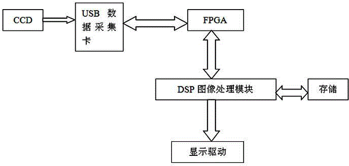
[0016] refer to figure 1 As shown, a drift scan camera synchronous satellite real-time orbit determination device, the device includes a drift scan CCD camera, used to stare at the starry sky and alternately shoot the drift scan mode, the CCD is connected to a USB data acquisition card through a USB data cable, It is used to convert the video signal collected by the CCD camera into a parallel digital image signal through the USB data acquisition card. cache in the logic device, and the FPGA programmable logic device realizes sequential logic control at the same time, and the FPGA programmable logic device is connected to the DSP image processing module through a parallel bus to ensure the timing control of the DSP image processing module and complete the connection with the DSP image processing module High-speed real-time data trans...


PUM


Abstract

The invention discloses a drift scanning camera synchronous satellite real-time orbit determination device. The device comprises a drift scanning CCD camera, wherein the drift scanning CCD camera is connected with a USB data acquisition card which is connected with FPGA programmable logic device, the FPGA programmable logic device is connected with a DSP image processing module which is respectively connected with a display driving module and a hard disc storage module which are used for displaying and storing the calculating result. According to the device, the DSP image processing module can be used for high speed arithmetic of big data, is programmable, and can be used for rapidly completing the large arithmetic amount in the synchronous satellite orbit determination to obtain the orbit determination result in real time, the real-time orbit determination of synchronous satellite is facilitated, furthermore, the structure is simple, the cost is low, and the reliability is high.

Description

technical field [0001] The invention relates to the field of synchronous satellite astronomical observation and astrometry, in particular to a device for real-time orbit determination of a synchronous satellite with a drift scanning camera. Background technique [0002] Geosynchronous orbit is a space neighborhood with very important value, especially in space communication, earth monitoring and space science neighborhood. According to my country's 11th Five-Year Plan, it is necessary to monitor all the geostationary satellites over the territory of our country. Therefore, research on key technologies such as the identification, capture and orbit determination of geosynchronous orbit targets is of great significance to promote the development of high-orbit space target monitoring methods in my country. The use of radar to observe geostationary satellites has its limitations. Radar cannot observe high-orbit artificial satellites and the accuracy of orbit determination is not ...

Claims


Application Information

Patent Timeline
Patent Type & Authority Applications(China)
IPC IPC(8): G01C21/24
CPCG01C21/24
Inventor 王军杨会玲柳红岩李岩孙慧婷
Owner SUZHOU UNIV OF SCI & TECH
Why Eureka
Try Eureka