Multiresolution multilayer successive point adding LiDAR (Light Detection and Ranging) filtering algorithm

A filtering algorithm and multi-resolution technology, which is applied in the field of multi-resolution and multi-layer LiDAR filtering algorithm, can solve the problem of low average calculation accuracy and achieve the effect of weakening the influence

Inactive Publication Date: 2014-04-02
SHANDONG UNIV OF SCI & TECH
View PDF2 Cites 9 Cited by
  • Summary
  • Abstract
  • Description
  • Claims
  • Application Information

AI Technical Summary

Problems solved by technology

In the follow-up, although relevant researchers improved the traditional algorithm or proposed some other new filtering algorithms, calculations based on 15 sets of experimental data provided by ISPRS showed that their average calculation accuracy was lower than that of adaptive TIN

Method used


Image

  • Multiresolution multilayer successive point adding LiDAR (Light Detection and Ranging) filtering algorithm
  • Multiresolution multilayer successive point adding LiDAR (Light Detection and Ranging) filtering algorithm
  • Multiresolution multilayer successive point adding LiDAR (Light Detection and Ranging) filtering algorithm

Examples


Embodiment Construction

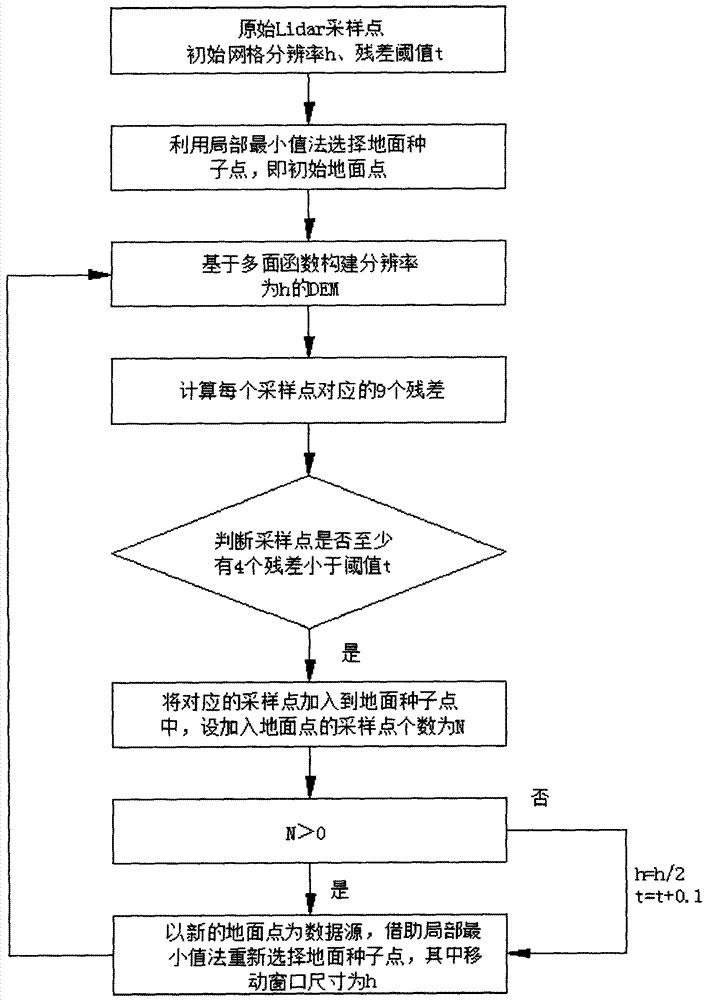
[0017] 1 Principle of multi-resolution and multi-layer successive point-added filtering algorithm

[0018] This method includes three layers of filtering: in the initial layer, first select some ground points as seed points by the local minimum method, then construct a certain resolution DEM by multi-surface function, and finally calibrate the sampling points whose residual error is less than the set threshold as the ground point. Repeat the above process until convergence. In the subsequent layers, the DEM resolution and residual threshold are gradually increased, and the calculation process in the initial layer is repeated until no sampling point is marked as a ground point, then the iteration is stopped, and the ground point data is output. Assume that the resolution of the DEM grid generated by the initial layer of this method is h, the residual threshold is t, and the layer count N=1. The specific calculation steps are as follows:

[0019] (1) Firstly, in the initial l...


PUM


Abstract

The invention discloses a multiresolution multilayer successive point adding LiDAR (Light Detection and Ranging) filtering algorithm. The algorithm comprises the steps of three-layer filtering: in an initial layer: selecting part of ground points as seed points by virtue of a local minimum method, constructing a DEM (Digital Elevation Model) with certain resolution by virtue of a multi-surface function interpolation algorithm, re-calculating the elevation difference between each sampling point and a corresponding DEM net point, labeling the point with the elevation difference less than an initial set threshold as the ground point, repeating the process till no sampling point is divided into the ground point; in the filtering of a second layer and a third layer: doubling the resolution of the DEM based on the anterior layer, increasing a corresponding residual error threshold, repeating the calculation process of the anterior layer till no sampling point is labeled as the ground point, stopping iteration, and outputting ground point data. The average calculation accuracy of the algorithm is slightly higher than that of a self-adapting TIN (Triangulated Irregular Network) algorithm, much higher than those of seven filtering algorithms developed before 2004, and higher than those of nonparametric successive filtering algorithms and the like developed in recent years.

Description

technical field [0001] The invention relates to a LiDAR filter algorithm with multi-resolution and multi-layer sequential point addition. Background technique [0002] LiDAR has become an indispensable ground supplementary system in DEM data acquisition technology due to its high speed, high precision and high density. LiDAR raw data mainly includes ground points and non-ground points, so the LiDAR sampling data must be filtered before being used for DEM construction, that is, the non-ground points in the raw data should be eliminated. Among them, the computational efficiency of the filtering algorithm significantly affects the DEM construction accuracy. [0003] According to the basic principle of non-ground point filtering in LiDAR data, traditional filtering algorithms can be divided into interpolation filtering, morphological filtering, slope filtering and segmentation filtering. The analysis of a large number of examples shows that each algorithm can obtain better fil...

Claims


Application Information

Patent Timeline
Patent Type & Authority Applications(China)
IPC IPC(8): G06T17/05G06T17/30
Inventor 陈传法阳凡林戴洪磊田茂义曹学伟
Owner SHANDONG UNIV OF SCI & TECH
Why Eureka
Try Eureka