
Methane profile orthogonal inversion method aiming at AIRS (atmospheric infrared sounder) hyper-spectrum satellite data

A methane profile and satellite data technology, which is applied in the field of satellite remote sensing and atmospheric composition inversion, and can solve the problems that the inversion results depend on the initial profile and cannot obtain convergent results.

Inactive Publication Date: 2014-04-23
INST OF REMOTE SENSING & DIGITAL EARTH CHINESE ACADEMY OF SCI
View PDF1 Cites 20 Cited by
  • Summary
  • Abstract
  • Description
  • Claims
  • Application Information

AI Technical Summary

Problems solved by technology

In the physical inversion algorithm, there are two very difficult problems: first, the initial profile X a Do not deviate too much from the real situation, otherwise the convergent result cannot be obtained; secondly, the prior error covariance matrix S a It needs to best represent the true state of the parameters to be inverted in a statistical sense, otherwise it is difficult to c

Method used


Image

  • Methane profile orthogonal inversion method aiming at AIRS (atmospheric infrared sounder) hyper-spectrum satellite data
  • Methane profile orthogonal inversion method aiming at AIRS (atmospheric infrared sounder) hyper-spectrum satellite data
  • Methane profile orthogonal inversion method aiming at AIRS (atmospheric infrared sounder) hyper-spectrum satellite data

Examples


Embodiment Construction

[0055] Hereinafter, the present invention will be described more fully, and exemplary embodiments of the invention will be shown. This invention may, however, be embodied in many different forms and should not be construed as limited to the exemplary embodiments set forth herein. Rather, these embodiments are provided so that this disclosure will be thorough and complete, and will fully convey the scope of the invention to those skilled in the art.

[0056] The satellite data in the present invention selects the clear-sky corrected radiance secondary standard product (L2-standard-cloud-cleared -radiance-product). This product uses the advanced microwave detector AMSU (Advanced Microwave Sounding Unit) with the same load to correct the radiance of some pixels with clouds, which greatly improves the utilization rate of data. AIRS is a swing-broom detection sensor, which uses infrared grating array spectroscopic technology, 2378 channels covering 650-2700cm -1 In the infrared ...


PUM


Abstract

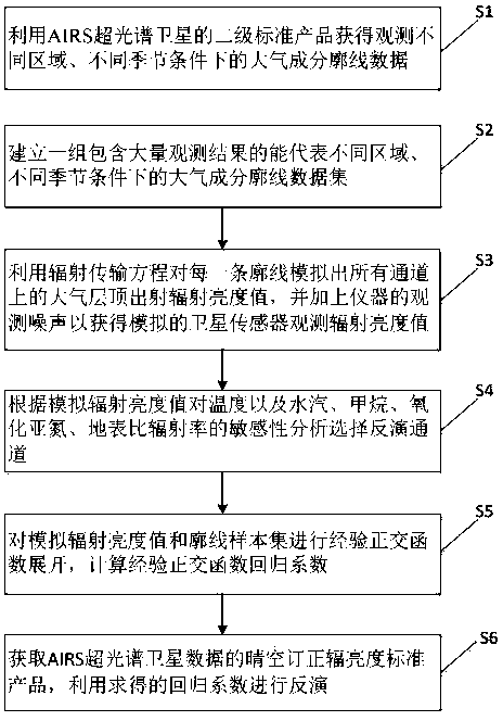
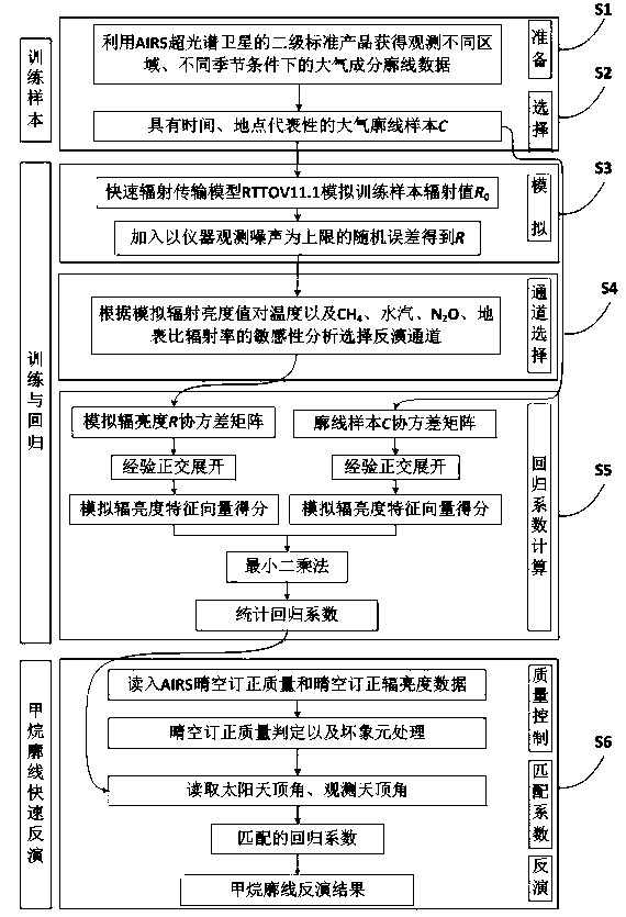
The invention discloses a methane profile orthogonal inversion method aiming at AIRS (atmospheric infrared sounder) hyper-spectrum satellite data. The method concretely comprises the following steps that a secondary standard product of an AIRS hyper-spectrum satellite is utilized for obtaining atmospheric composition profile data under the conditions of different regions and different seasons; a group of sets which contain a great number of observation results and can represent the atmospheric composition profile data under the conditions of different regions and different seasons are built; a radiation transmission equation is utilized for simulating an atmospheric top layer emergent radiation brightness value on a target passage for each profile, in addition, the observation noise of an instrument is added for obtaining the simulated satellite sensor observation radiation brightness value; the sensitivity of the atmospheric composition and the temperature is analyzed according to the simulated radiation brightness value for selecting the inversion passage; training sample sets are subjected to empirical orthogonal function expansion, and an empirical orthogonal function regression coefficient is calculated; cloud-clearing radiation brightness standard products of the AIRS hyper-spectrum satellite data are obtained, and the obtained regression coefficient is used for inversion.

Description

technical field [0001] The present invention relates to the technical field of atmospheric component inversion in the field of satellite remote sensing, relates to a methane profile inversion method for AIRS hyperspectral satellite data, and in particular to a fast method for methane profile of AIRS hyperspectral satellite data based on empirical orthogonal function regression method inversion method. Background technique [0002] Methane is an important greenhouse gas, and its greenhouse effect per unit mass is greater than that of CO 2 20 times larger. So far, methane accounts for about 20% of the enhanced greenhouse effect, second only to CO 2 . The radiative forcing of methane emitted by humans is 0.48W / m 2 , probably CO 2 (1.66W / m 2 ) of one-third. Methane also plays an important role in the chemical processes of the troposphere and peace processes, such as the formation of formaldehyde (CH 2 O), carbon monoxide (CO) and ozone (O 3 ), thereby affecting the oxid...

Claims


Application Information

Patent Timeline
IPC IPC(8): G01S7/48G01S17/88G01N21/3504
CPCG01S7/4802G01S17/95
Inventor 张莹陈良富苏林
Owner INST OF REMOTE SENSING & DIGITAL EARTH CHINESE ACADEMY OF SCI
Learn More