Tide correction method based on satellite altimetry data itself

A satellite altimetry and correction method technology, applied in the field of satellite altimetry, can solve the problems of low precision of the global tidal model, unsuitability for tidal correction of satellite altimetry data, poor applicability, etc.

Active Publication Date: 2016-01-20
INST OF REMOTE SENSING & DIGITAL EARTH CHINESE ACADEMY OF SCI
View PDF0 Cites 2 Cited by
  • Summary
  • Abstract
  • Description
  • Claims
  • Application Information

AI Technical Summary

Problems solved by technology

The global tidal model has low accuracy and poor applicability in offshore areas, and is not ...

Method used


Image

  • Tide correction method based on satellite altimetry data itself
  • Tide correction method based on satellite altimetry data itself
  • Tide correction method based on satellite altimetry data itself

Examples


Embodiment Construction

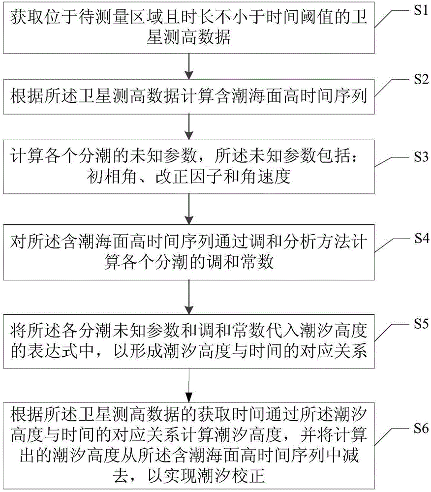
[0039] The specific implementation manners of the present invention will be further described in detail below in conjunction with the accompanying drawings and embodiments. The following examples are used to illustrate the present invention, but are not intended to limit the scope of the present invention.

[0040] figure 1 It is a flow chart of the tide correction method based on satellite altimetry data itself in an embodiment of the present invention; refer to figure 1 , the method includes the following steps:

[0041] S1: Obtain satellite altimetry data located in the area to be measured and whose duration is not less than the time threshold;

[0042] S2: Calculate the tidal sea surface height time series according to the satellite altimetry data; in this step, do not perform tidal correction when calculating the sea surface height according to the satellite altimetry data, that is, do not use the included geophysical data The global tidal model information performs ti...


PUM


Abstract

The invention discloses a tide correction method based on satellite altimetry data, and relates to the technical field of satellite altimetry. Tide information is extracted through a sea level height time sequence measured by an altimetric measurement satellite, tide correction is performed on the satellite altimetry data according to the tide information, as a result, inadaptability, caused by usage of a global tide model, to tide correction of regional sea areas can be avoided, and the practicability and accuracy of the satellite altimetry data in monitoring and predicting regional sea level changes are improved.

Description

technical field [0001] The invention relates to the technical field of satellite altimetry, in particular to a tidal correction method based on satellite altimetry data itself. Background technique [0002] Satellite altimetry technology observes the distance between the satellite and the sea surface by transmitting and receiving radar pulse signals. Since the 1990s, a series of research results on the analysis and study of sea level change trends have been published, most of which are based on altimetry data from T / P satellites and Jason-1 satellites. [0003] The T / P (TOPEX / Poseidon) satellite was jointly launched by the National Aeronautics and Space Administration (NASA) and the French Space Agency (CNES) on August 10, 1992. The full name is the Poseidon Ocean Terrain Experimental Satellite. The two altimeters on board were designed by NASA of the United States and CNES of France. The orbital height of the satellite is 1336KM, and the orbital inclination is 66°, which ...

Claims


Application Information

Patent Timeline
IPC IPC(8): G01S7/40
CPCG01S7/40G01S13/882
Inventor 张霞王晋年庄智帅通孙艳丽
Owner INST OF REMOTE SENSING & DIGITAL EARTH CHINESE ACADEMY OF SCI
Why Eureka
Try Eureka