Education geographic information system

A geographic information system and related information technology, applied in geographic information databases, digital data processing, special data processing applications, etc., can solve the problems that geographic information systems do not focus on information systems in a certain field and do not appear, and achieve The effect of convenient query

Inactive Publication Date: 2014-05-07
DALIAN SHIBO TECH
View PDF0 Cites 6 Cited by
  • Summary
  • Abstract
  • Description
  • Claims
  • Application Information

AI Technical Summary

Problems solved by technology

[0003] However, the current geographic information system does not focus on an information system in a certain field, such as an information system applied to the field of education, which has not yet appeared

Method used


Image

  • Education geographic information system

Examples


Embodiment Construction

[0011] In order to make the purpose, technical solutions and advantages of the embodiments of the present invention more clear, the technical solutions in the embodiments of the present invention are clearly and completely described below in conjunction with the drawings in the embodiments of the present invention:

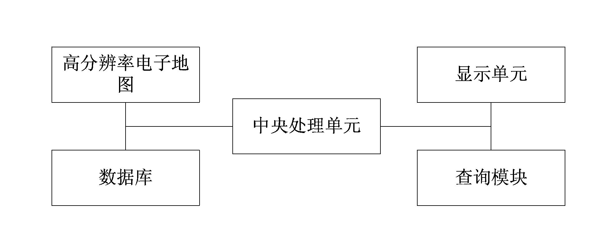
[0012] Such as figure 1 Shown: An educational geographic information system with

[0013] A high-resolution electronic map, a database for use with the electronic map, a query module for use with the electronic map and database, a query module for displaying relevant information, and a central processing module for coordinating the above operations;

[0014] The electronic map has at least: annual sublayer, layout planning sublayer, key project sublayer, peripheral facilities sublayer, administrative division sublayer, school sublayer, urban and rural sublayer and statistics sublayer .

[0015] Further, preferably, the system supports combined query by county, d...


PUM


Abstract

The invention discloses an education geographic information system which is provided with a high-resolution electronic map, a database used in cooperation with the electronic map, an inquiry module used in cooperation with the electronic map and the database, an inquiry module for displaying related information and a central processing module coordinating the operation. The electronic map is at least provided with an annual sub-graph layer, a layout planning sub-graph layer, a major project sub-graph layer, a peripheral facility sub-graph layer, an administrative division sub-graph layer, a school sub-graph layer, an urban and rural sub-graph layer and a statistics sub-graph layer. By the adoption of the technical scheme, according to the education geographic information system, the corresponding map layer and the database are added, education information of one place is comprehensively recorded, and therefore a user can conveniently inquire educational institutions of one place.

Description

technical field [0001] The invention relates to a geographic information system, in particular to an educational geographic information system suitable for Dalian. Background technique [0002] Geographic Information System (Geographic Information System or Geo-Informationsystem, GIS) is sometimes called "geographic information system" or "resource and environmental information system". It is a specific and very important spatial information system. It is a technical system that collects, stores, manages, calculates, analyzes, displays and describes the relevant geographical distribution data in the space of the entire or part of the earth's surface (including the atmosphere) with the support of computer hardware and software systems. [0003] However, the current geographic information system does not focus on information systems in a certain field, such as information systems applied to the field of education, which have not yet appeared. Contents of the invention [0...

Claims


Application Information

Patent Timeline
Patent Type & Authority Applications(China)
IPC IPC(8): G06F17/30
CPCG06F16/9537G06F16/29
Inventor 李宾
Owner DALIAN SHIBO TECH
Why Eureka
Try Eureka