Road three-dimensional fine modeling method based on elevation points and road outline face

A modeling method and elevation point technology, applied in the field of geospatial 3D modeling, can solve problems such as the inability to meet the requirements of practical applications, and achieve the effect of shortening computing time

Inactive Publication Date: 2014-06-18
NANJING UNIV
View PDF2 Cites 21 Cited by
  • Summary
  • Abstract
  • Description
  • Claims
  • Application Information

AI Technical Summary

Problems solved by technology

Existing methods for 3D modeling of roads have many defe...

Method used


Image

  • Road three-dimensional fine modeling method based on elevation points and road outline face
  • Road three-dimensional fine modeling method based on elevation points and road outline face
  • Road three-dimensional fine modeling method based on elevation points and road outline face

Examples


Embodiment Construction

[0028] The purpose and effects of the present invention will become more apparent by referring to the accompanying drawings in detail of the present invention.

[0029] The present embodiment is based on the road three-dimensional fine modeling method of elevation point and road contour surface, comprises the following steps:

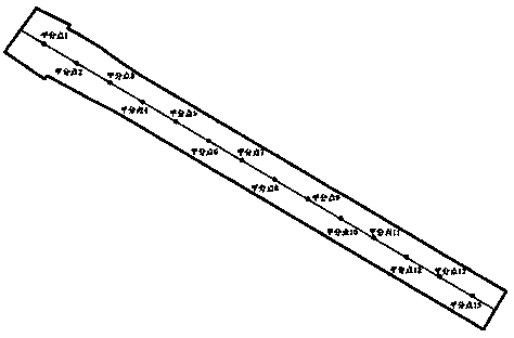
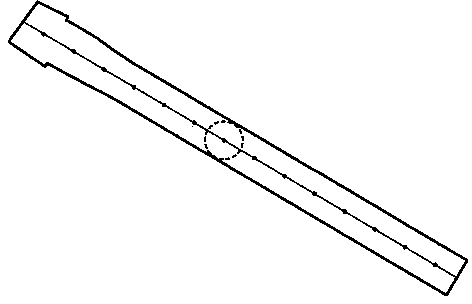
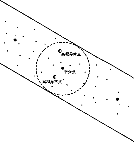
[0030] Step 1: Divide the center line of the road contour surface equally at the same interval, and record each bisect point (see figure 1 ).

[0031] Obtaining the bisector is the basis for dividing the road surface into patches. The selection of the bisector determines the size of the patch and the accuracy of the 3D modeling of the road. The more accurate the precision is, the more complex the model structure and the larger the storage volume will be if the number of patches is too large; otherwise, the number of patches will be too small to fully express the three-dimensional shape of the road surface and lose the accuracy of details. Therefore, t...


PUM


Abstract

The invention provides a road three-dimensional fine modeling method based on elevation points and a road outline face. The road outline face is divided into a plurality of sections with equal spaces through central lines of the road outlet face, a three-dimensional state of each road section is simulated, a whole road three-dimensional model is formed through combination, and therefore the three-dimensional change condition of each part of the road face can be better simulated. The searching radius of the elevation point of each bisecting point is limited within the road face, so that interference caused by the elevation outside the road face is avoided, and therefore non-relevant elevation points can be accurately removed and a contribution is made to accurate calculation of the elevation of the road face. Thus, the overall division thought is utilized, the measures that the face is divided into sections, abnormal elevation points are removed, and spatial interpolation of the elevation is conducted are taken, and the three-dimensional model of the road face is accurately established, so that the purpose of three-dimensional modeling automation is achieved. An experiment result shows that the method can well satisfy the actual requirements on the aspects of modeling form effects, accuracy and speed.

Description

technical field [0001] The invention relates to a three-dimensional fine road modeling method based on elevation points and road contour surfaces, and belongs to the technical field of three-dimensional modeling in geographic space. Background technique [0002] With the development of GIS technology, computer technology and network technology, digitizing and virtualizing real space to establish digital geographic space has become an important means for countries in the world to grasp the trend of high technology and promote economic development, represented by digital city and digital earth Digital geospatial plays an important role in land use supervision, spatial information management, urban system planning and management. The foundation of digital geospatial establishment is the establishment of three-dimensional model of geographic data. Digital Geospatial is a computer-based virtual reality system that interacts with users through monitors, touch screens, mice, keybo...

Claims


Application Information

Patent Timeline
IPC IPC(8): G06T17/05
Inventor 王结臣陈文龙芮一康倪皓晨伍钟洁
Owner NANJING UNIV
Why Eureka
Try Eureka