Multi-baseline interference synthetic aperture radar 3D reconstruction method

A technology of interferometric synthetic aperture and synthetic aperture radar, which is used in radio wave measurement systems, reflection/re-radiation of radio waves, utilization of re-radiation, etc.

Active Publication Date: 2014-06-25
CHINESE ACAD OF SURVEYING & MAPPING
View PDF6 Cites 22 Cited by
  • Summary
  • Abstract
  • Description
  • Claims
  • Application Information

AI Technical Summary

Problems solved by technology

[0005] The purpose of the present invention is to solve the shortcomings of the existing multi-baseline interferometric SAR technology for obtaining three-dimensional information on the surface, and proposes a

Method used


Image

  • Multi-baseline interference synthetic aperture radar 3D reconstruction method
  • Multi-baseline interference synthetic aperture radar 3D reconstruction method
  • Multi-baseline interference synthetic aperture radar 3D reconstruction method

Examples


Embodiment Construction

[0040] The present invention will be described in further detail below in conjunction with the accompanying drawings.

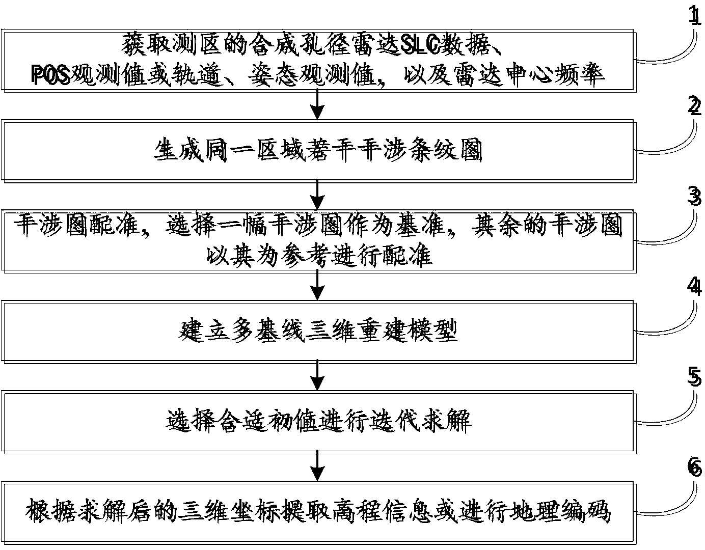
[0041]This multi-baseline interferometric SAR method is based on a rigorous 3D reconstruction model, avoids phase unwrapping, and overcomes the defects that the current multi-baseline interferometric SAR methods are mostly based on approximate models and the result accuracy is not high. The methods are rigorous. Consistent with the single baseline method, this method is based on a 3D reconstruction model, which is composed of R-D equations and interference equations, and the 3D coordinates of the target point are calculated by using the absolute interferometric phase and related system parameters. Under the condition of multiple baselines, phase unwrapping is not performed, and the geometric relationship of multiple sets of interference data is used to simultaneously solve the integer cycle number and the three-dimensional coordinates of the target point.

...


PUM


Abstract

The invention relates to a multi-baseline interference synthetic aperture radar 3D reconstruction method. According to the method, a 3D coordinate is directly calculated from a plurality of interference phases, the method comprises the steps of (1) obtaining the aviation synthetic aperture radar single look complex data and POS observation values of a measured region or space synthetic aperture radar data single look complex data and orbit and attitude observation values, and radar center frequency, (2) generating multiple interference fringe patterns of the same region, (3) carrying out interference image matching and selecting one interference image as a basis and other interference images as references to carrying out matching, (4) establishing a multi-baseline 3D reconstruction model, (5) selecting an appropriate initial value to carry out iteration solution, and (6) extracting elevation information or carrying out geographic coding according to a solved 3D coordinate. According to the method, the interference phase unwrapping can be avoided, an accidental error is weakened, the precision of a DEM is raised, the provided scheme can play an important role in complex terrain earth surface 3D reconstruction, and the method has a good technical effect.

Description

technical field [0001] The invention belongs to the field of digital photogrammetry of remote sensing images, in particular to synthetic aperture radar interferometry to obtain three-dimensional information of the earth surface. Background technique [0002] Synthetic aperture radar interferometry is a technology that uses single-view complex data covering two scenes with small viewing angle differences to form an interference fringe pattern and obtains the target elevation or three-dimensional coordinates through further processing. Multi-baseline interferometric synthetic aperture radar technology uses three or more single-view Calculate the elevation or three-dimensional information of the target point based on complex data. [0003] Generally speaking, the multi-baseline interferometric SAR (Synthetic Aperture Radar) methods mainly include: (1) Maximum Likelihood Estimation (MLE) method, according to the proportional relationship of the baseline length, the unambiguous i...

Claims


Application Information

Patent Timeline
IPC IPC(8): G01S13/90
CPCG01S7/41G01S13/9023
Inventor 张继贤花奋奋黄国满卢丽君赵争
Owner CHINESE ACAD OF SURVEYING & MAPPING
Why Eureka
Try Eureka