Geological radar detection method for karst non-continuity soil and rock distribution

A technology of geological radar and detection method, which is applied in the direction of climate sustainability, electromagnetic wave detection, water resources assessment, etc., to achieve the effect of high precision and small error

Inactive Publication Date: 2014-07-09
INST OF SUBTROPICAL AGRI CHINESE ACAD OF SCI
View PDF4 Cites 11 Cited by
  • Summary
  • Abstract
  • Description
  • Claims
  • Application Information

AI Technical Summary

Problems solved by technology

At present, in karst areas, ground radar is mainly applied to the archaeological investigation of caves, and there is stil

Method used


Image

  • Geological radar detection method for karst non-continuity soil and rock distribution
  • Geological radar detection method for karst non-continuity soil and rock distribution
  • Geological radar detection method for karst non-continuity soil and rock distribution

Examples


Embodiment 1

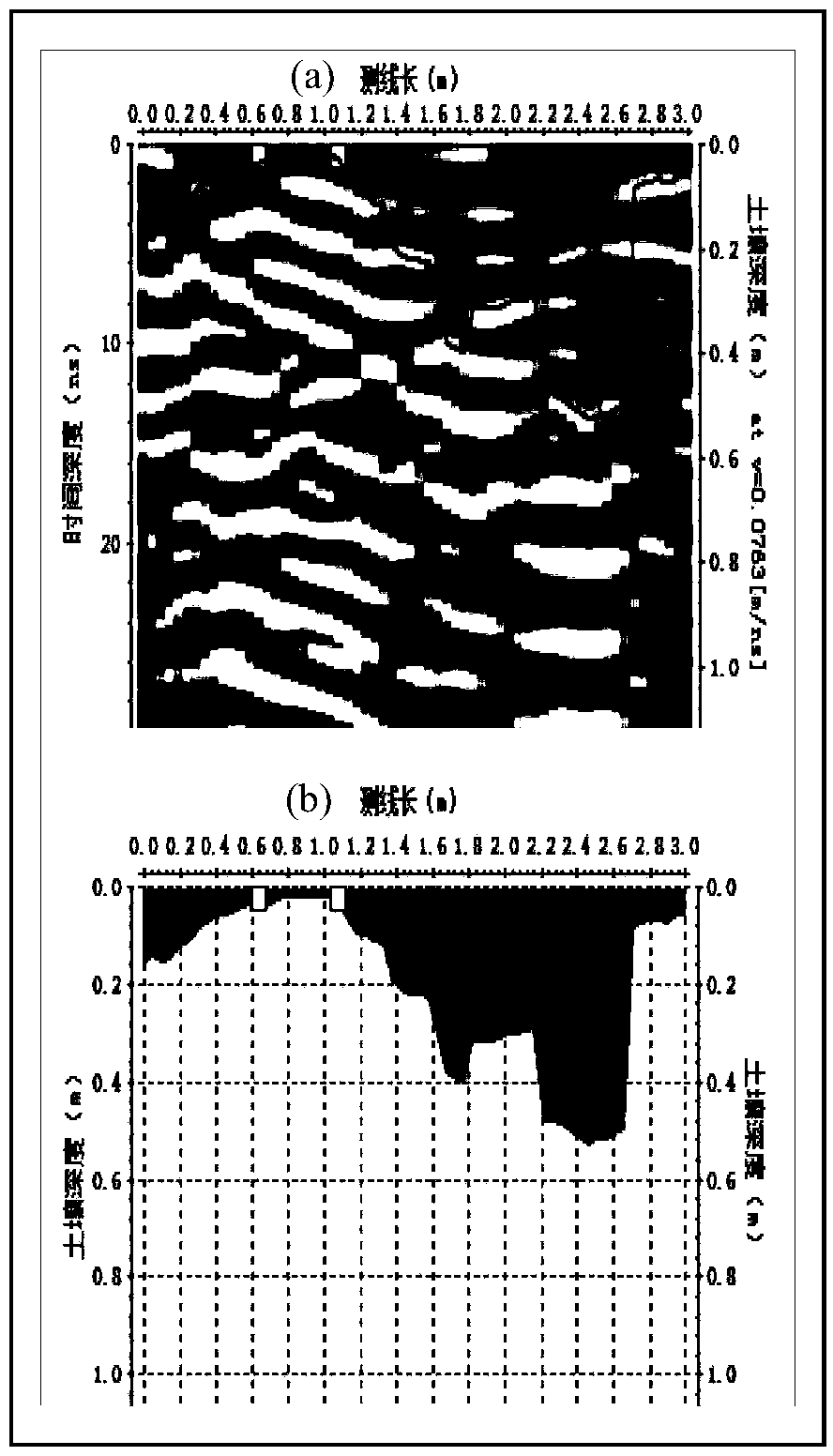
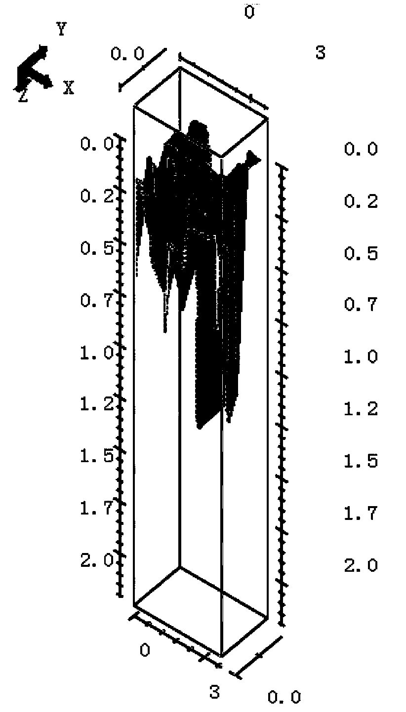
[0030] The present invention will be further described below in conjunction with the accompanying drawings. The sample area to be tested in the embodiment is located at the downhill position of a typical karst peak-cluster depression in Huanjiang County, Guangxi.

[0031] A geological radar detection method for karst discontinuous soil and rock distribution, the steps are:

[0032] A. Select a typical sample plot in the area to be tested, the sample size is 2 m × 3 m, and remove the plants and litter on the soil surface in the sample plot;

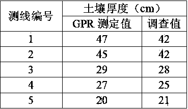
[0033] B. Set 5 measuring lines at equal intervals of 0.5 m in the quadrat, each with a length of 3 m;

[0034] C. Preliminary detection of the soil depth in the sample plot by the drill method is within 0.45 m;

[0035] D. Ground-penetrating radar model: ProEx system host and 800 and 500 MHz shielded antenna produced by Swedish MALA company; 500 MHz center frequency antenna is selected; detection parameters are set as: time window 62.09 ...


PUM


Abstract

The invention discloses a geological radar detection method for karst non-continuity soil and rock distribution. The geological radar detection method includes the steps that A, a rectangular quadrat in a region to be detected is selected to remove plants on the surface of soil in the quadrat; Bmeasuring lines are arranged at equal intervals in the quadrat; C, a crooked chisel is inserted into the soil to preliminarily detect the soil depth range in the quadrat; D, the model of a ground penetrating radar is MALA-ProEx; E, the measuring lines are selected to measure; F, GPR data on all the measuring lines in the quadrat are obtained; G, soil texture is measured by the adoption of an aerometer method according to S-type distribution points in the quadrat; H, the category and water content of the soil texture are measured; J, according to a relational expression, electromagnetic wave speed is calculated; K, the GPR data of all the measuring lines and the electromagnetic wave speed in the quadrat are input into 3D software, so that a three-dimensional image of soil and rock distribution in the quadrat is obtained. The method used for detecting soil and rock distribution is high in precision, visual in reflection, rapid, free of damage and wide in application range.

Description

technical field [0001] The invention belongs to the technical field of agricultural ecology and environmental geology, and more specifically relates to a geological radar detection method for karst discontinuous soil and rock distribution. Continuous soil and rock distribution are detected. Background technique [0002] The world's karst area is about 22 million km 2 , accounting for about 15% of the total land area of ​​the world. The total area of ​​karst in Southwest my country is about 550,000 km 2 . Due to the slow soil formation process and shallow soil layer in karst areas, on the one hand, the soil controlled by karstification migrates vertically or laterally along the karst trough and karst ditch, resulting in discontinuity in the three-dimensional space of the soil profile, interlaced distribution of soil and rock, and a high rate of rock exposure On the other hand, due to karstification, the dual structure of the soil is developed, the rock-soil interface...

Claims


Application Information

Patent Timeline
IPC IPC(8): G01V3/12
CPCY02A90/30
Inventor 苏以荣陈香碧夏银行黎蕾
Owner INST OF SUBTROPICAL AGRI CHINESE ACAD OF SCI
Why Eureka
Try Eureka