Street view image storage method and device based on mixed tile pyramids

A tile pyramid and image technology, applied in the field of surveying and mapping, can solve the problems of large overlap of street view images and data redundancy, and achieve the effect of efficient browsing, data redundancy removal, and overlap reduction.

Active Publication Date: 2014-07-09
BEIJING UNIV OF CIVIL ENG & ARCHITECTURE
View PDF6 Cites 14 Cited by
  • Summary
  • Abstract
  • Description
  • Claims
  • Application Information

AI Technical Summary

Problems solved by technology

[0005] The invention provides a method and device for storing street view images based on a hybrid tile pyramid, which solves the technical problems of large overlap of street view images and redundant data in the prior art

Method used


Image

  • Street view image storage method and device based on mixed tile pyramids
  • Street view image storage method and device based on mixed tile pyramids
  • Street view image storage method and device based on mixed tile pyramids

Examples


Embodiment 1

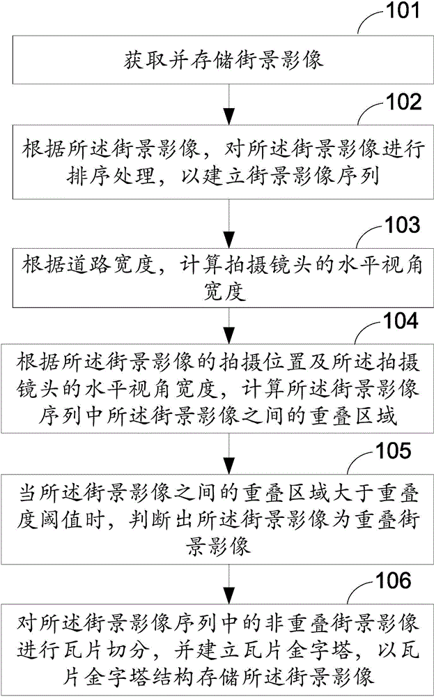
[0033] Embodiment 1 of the present invention provides a method for storing street view images based on a hybrid tile pyramid, such as figure 1 As shown, the method includes the following steps:

[0034] Step 101, acquiring and storing street view images;

[0035] Wherein, the street view image may be captured by a street view camera device and stored in a storage medium.

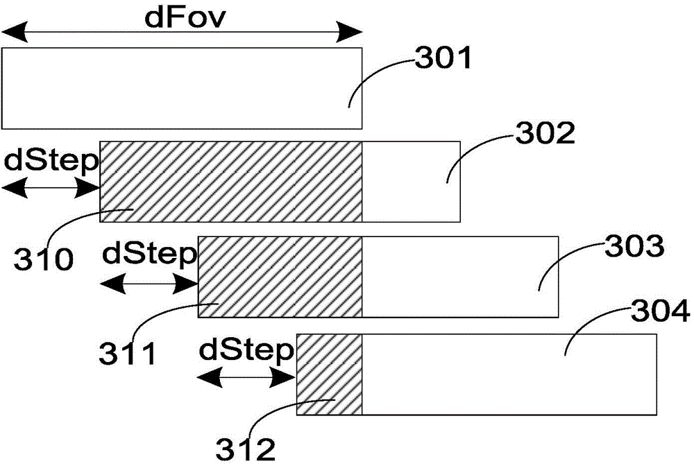
[0036] Step 102, sorting the street view images according to the street view images, so as to establish a sequence of street view images;

[0037] Wherein, the street view images are sorted in the order of the collection time of the street view images, and the synchronous corresponding sequence relationship of the street view images is established according to the time order of the street view images, and the sequence of street view images is established.

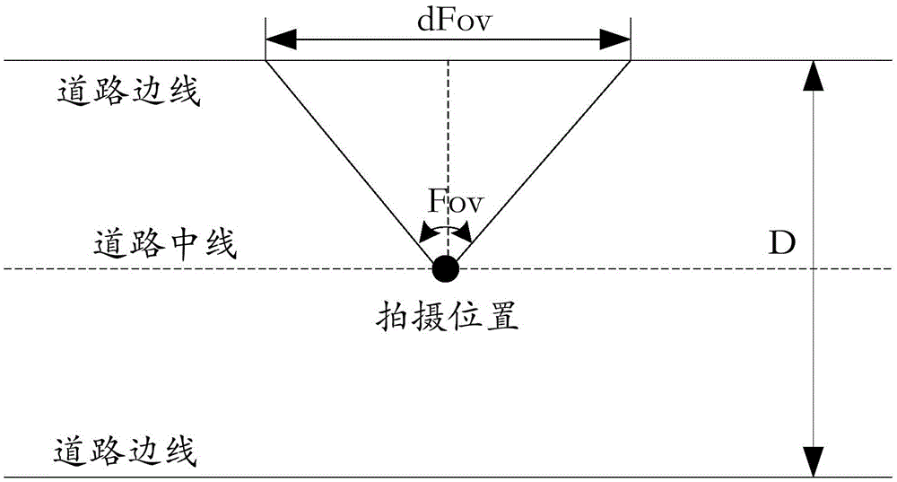
[0038] Step 103, calculate the horizontal angle of view width of the shooting lens according to the width of the road;

[0039] Among them, it is nece...

Embodiment 2

[0051] Through the street view image storage method based on the hybrid tile pyramid disclosed in Embodiment 1 of the present invention, the overlap degree of street view images is greatly reduced through the thinning of street view images and the construction of a pyramid model, and efficient browsing of images is realized. As the overlap of street view images is reduced, the measurement accuracy is also reduced. Embodiment 2 of the present invention is based on this problem. On the basis of Embodiment 1 in Embodiment 2 of the present invention, a hybrid storage structure for encrypting street view images at the bottom of the pyramid is designed. By inserting enough street view images into the bottom layer of street view image data to meet high The degree of image overlap required for precision measurement allows both fast viewing and precise measurement. The specific method is as Image 6 As shown, the method includes the following steps:

[0052] Step 601, acquiring and s...

Embodiment 3

[0068] Embodiment 3 of the present invention provides a device for storing street view images based on a hybrid tile pyramid, such as Figure 7 As shown, the device includes:

[0069] A storage module 710, configured to acquire and store street view images;

[0070] A sequence building module 720, configured to sort the street view images according to the street view images stored in the storage module, so as to establish a street view image sequence;

[0071] The first calculation module 730 is used to calculate the horizontal angle of view width of the shooting lens according to the width of the road;

[0072] The second calculation module 740 is configured to calculate the overlap between the street view images in the street view image sequence according to the shooting position of the street view image and the horizontal angle of view width of the shooting lens calculated and obtained by the first calculation module area;

[0073] A judging module 750, configured to jud...


PUM


Abstract

The invention relates to the technical field of surveying and mapping, and discloses a street view image storage method and device based on mixed tile pyramids. The method includes acquiring and storing street view images; sorting the street view images according to the street view images to establish street view image sequences; calculating the horizontal angle width of a shooting camera according to the width of a street, and calculating overlapping regions of the street view images in the street view image sequences according to shooting positions of the street view images and the horizontal angle width of the shooting camera; when the overlapping regions of the street view images are larger than an overlap threshold, judging the street view images to be overlapped street view images, performing tile dividing on non-overlapped street view images in the street view image sequences, and establishing mixed tile pyramids to store the street view images. Overlapping degree of the street view images is reduced effectively, data redundancy is removed, efficient browsing of images is realized, and accurate measurement can be considered during quick browsing.

Description

technical field [0001] The present invention relates to the technical field of surveying and mapping, in particular to a method and device for storing street view images based on hybrid tile pyramids. Background technique [0002] With the development of 3D visualization and virtual reality technology, street view maps have begun to provide map services for the public. Through the street view map, users can be provided with 360-degree panoramic images of cities, streets or other environments, and users can obtain an immersive map browsing experience through this service. The core idea of ​​the street view map is to use the full-element "what you see is what you get" feature of the image to realize the visualization of the real world, and use the principle of photographic geometry to realize the quantifiable and mineable objects of interest. [0003] It can be seen that designing an efficient storage structure to achieve the visual fluency and visual fidelity of street view ...

Claims


Application Information

Patent Timeline
Patent Type & Authority Applications(China)
IPC IPC(8): G06F17/30
CPCG06F16/29G06F16/50
Inventor 靖常峰杜明义刘扬杜应龙杜萌
Owner BEIJING UNIV OF CIVIL ENG & ARCHITECTURE
Why Eureka
Try Eureka