Urban pipe line detection data fast mapping method and system based on GIS platform

A technology for detecting data and pipelines, which is applied in the rapid mapping and system field of urban pipeline detection data based on the GIS platform, which can solve the problems of time-wasting database association query and database reading operations, and reduce efficiency and reduce database reading operations , Simplify the effect of the mapping process

Active Publication Date: 2014-07-16
TAIHUA WISDOM IND GRP CO LTD
View PDF2 Cites 9 Cited by
  • Summary
  • Abstract
  • Description
  • Claims
  • Application Information

AI Technical Summary

Problems solved by technology

[0012] Based on the above analysis, it is found that the bottleneck of traditional pipeline mapping is more time wasted on database association query and database reading operations

Method used


Image

  • Urban pipe line detection data fast mapping method and system based on GIS platform
  • Urban pipe line detection data fast mapping method and system based on GIS platform
  • Urban pipe line detection data fast mapping method and system based on GIS platform

Examples


Embodiment Construction

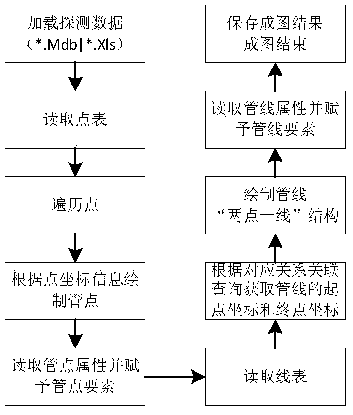
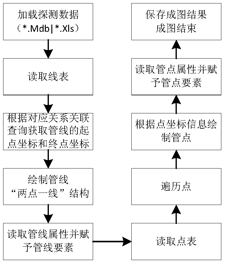
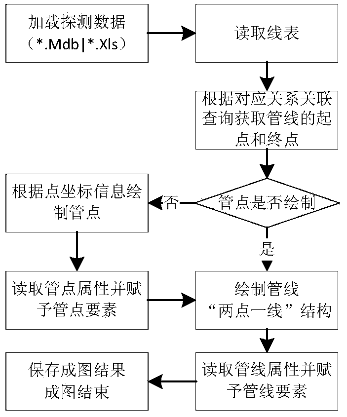
[0087] The present invention will be further described below in conjunction with the accompanying drawings and embodiments.

[0088] The invention is based on the ArcGIS platform and utilizes the secondary development technology of the ArcGIS to realize the mapping of urban pipeline detection data. The urban pipeline detection data format takes the Access database as an example.

[0089] 1. Add the coordinate field of the starting and ending points of the pipeline in the pipeline table of the pipeline detection data.

[0090] like Figure 4 and Figure 5 As shown, the detection data field changes before and after the field is added: the four fields "Start Point X Coordinate", "Start Point Y Coordinate", "End Point X Coordinate", and "End Point Y Coordinate" have been added.

[0091] 2. Assign values ​​to the coordinates of the start and end points of the pipeline according to the connection relationship between the pipeline and the pipe points.

[0092] By assigning values...


PUM


Abstract

The invention discloses an urban pipe line detection data fast mapping method and system based on a GIS platform. The method includes the steps that pipe line starting point and ending point coordinate fields are added, and value assignment is carried out on pipe line starting point and ending point coordinates; starting point and ending point coordinate information of pipe lines is directly read during pipe line mapping by carrying out value assignment on all endpoint spatial positions needed by the pipe lines so that the repeated operation of reading the pipe point coordinate information through the relation between the pipe lines and pipe points during mapping can be avoided; pipe line list mapping is carried out, wherein a pipe line list is read and traversed, the pipe lines are drawn, and pipe line attributes are read and assigned to pipe line elements; pipe point list mapping is carried out, wherein a pipe point list is read and traversed, pipe points are drawn according to point coordinate information, and pipe point attributes are read and assigned to pipe point elements; mapping is finished. According to the method, more work is completed before pipe line mapping on the basis that the pipe line mapping principle is understood, so that frequent database reading operation is simplified in the mapping process, especially for mapping with a large data volume.

Description

technical field [0001] The invention relates to a method and system for quickly forming maps of urban pipeline detection data based on a GIS platform. Background technique [0002] When pipeline mapping is performed from detection data (assuming that the data has been checked and corrected), the traditional mapping methods basically include the following types, and the overall operating efficiency is basically the same. The overall analysis is as follows: [0003] Traditional drawing method 1: such as figure 1 As shown, first map the pipe points: by traversing the pipe point data table, read the pipe point coordinate information to draw the pipe points, and at the same time assign the pipe point attribute information; The statement temporarily builds a table, and obtains the coordinates of the start and end points of the pipeline, and then draws the pipeline according to the coordinate information of the start point and end point of the pipeline (that is, the two end point...

Claims


Application Information

Patent Timeline
Patent Type & Authority Applications(China)
IPC IPC(8): G06F17/30
CPCG06F16/29
Inventor 柳宇刚张利国苏军
Owner TAIHUA WISDOM IND GRP CO LTD
Why Eureka
Try Eureka