
A high-resolution method for modeling permanent scatterers with separation of buildings and backgrounds

A permanent scatterer and modeling method technology, applied in the field of permanent scatterer modeling and parameter estimation, can solve problems that affect the accuracy of building deformation information extraction, achieve small elevation errors, small deformation rate values, and reduce impact effects

Active Publication Date: 2017-10-10
HANGZHOU NORMAL UNIVERSITY
View PDF2 Cites 0 Cited by
  • Summary
  • Abstract
  • Description
  • Claims
  • Application Information

AI Technical Summary

Problems solved by technology

At the same time, considering that the building elevation phase and deformation phase are easily mixed together, if the building elevation cannot be accurately calculated, it will directly affect the extraction accuracy of building deformation information

Method used


Image

  • A high-resolution method for modeling permanent scatterers with separation of buildings and backgrounds
  • A high-resolution method for modeling permanent scatterers with separation of buildings and backgrounds
  • A high-resolution method for modeling permanent scatterers with separation of buildings and backgrounds

Examples


Embodiment

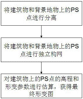
[0021] Embodiment: a kind of high-resolution building of this embodiment and the permanent scatterer modeling method of background separation, such as figure 1 shown, including the following steps:

[0022] S01, separating the PS points on the buildings and background features;

[0023] S02, the PS points on the buildings and background features are independently constructed;

[0024] S03. Estimating the elevation and deformation parameters of PS points on the building to obtain a final deformation map.

[0025] 1. Separation of PS points on buildings and background features

[0026] The present invention adopts an object-oriented classification method to realize the separation of PS points on buildings and background features. The whole classification method is as follows: first, the image is segmented according to the adjacent pixel grayscale and texture on the adjacent SAR image, using An edge-based segmentation algorithm that is fast to calculate and can produce multi-sca...


PUM


Abstract

The invention discloses a high-resolution building and background separation permanent scatterer modeling method, which includes the following steps: S01, separating the PS points on the building and the background object; S02, separating the building and the background The PS points on the background feature are independently networked; S03, the elevation and deformation parameters of the PS points on the building are estimated to obtain the final deformation map. The results obtained by this scheme have small elevation errors and small deformation rate values, which effectively reduces the influence of high phase gradients on building elevation and deformation calculations, and are suitable for telemetry modeling in high-resolution urban environments.

Description

technical field [0001] The invention relates to the field of microwave radar remote sensing imaging, in particular to a permanent scatterer modeling and parameter estimation method for separating buildings and background objects in an urban environment under high-resolution conditions. Background technique [0002] Synthetic Aperture Radar Interferometry (InSAR) technology is a microwave radar remote sensing technology developed in recent years. As an extension of InSAR technology, D-InSAR, that is, differential synthetic aperture radar interferometry, uses radar images acquired by satellites passing through the same area twice to perform differential interference to extract land subsidence information. The advantage of D-InSAR technology is that it can collect radar images around the clock. Theoretically, the accuracy of D-InSAR technology for land subsidence monitoring can reach millimeter level. The main limitations of D-InSAR technology are time decoherence, space decoh...

Claims


Application Information

Patent Timeline
Patent Type & Authority Patents(China)
IPC IPC(8): G06F17/50
Inventor 张登荣王洁周立凡
Owner HANGZHOU NORMAL UNIVERSITY
Learn More