Unmanned aerial vehicle space navigation method, unmanned aerial vehicle control system and unmanned aerial vehicle control device

A navigation method and unmanned aerial vehicle technology, applied in the field of navigation, can solve the problems that unmanned aerial vehicles can not work for a long time, and GPS navigators cannot realize unmanned aerial vehicle navigation, identification and detection, etc.

Inactive Publication Date: 2014-08-27
CHINA AGRI UNIV
View PDF6 Cites 32 Cited by
  • Summary
  • Abstract
  • Description
  • Claims
  • Application Information

AI Technical Summary

Problems solved by technology

[0003] However, manual remote control devices are labor-intensive, and determining the flight status of the drone through human eyes cannot make the drone work continuously for a long time, and the drone cannot be precisely controlled, thereby failing to expand the application range of the drone
[0004] The sensor navigation device including the airborne camera is easy to increase the load of the UAV, resulting in a short continuous working time of the UAV; in addition, the sensor navigation device cannot detect the surrounding obstacles and the target that the UAV needs to reach. make better judgment
[0005] The accuracy of GPS navigator for UAV navigation is relatively high in a long time and long distance, but GPS navigator cannot realize the indoor navigation of UAV. identify and detect

Method used


Image

  • Unmanned aerial vehicle space navigation method, unmanned aerial vehicle control system and unmanned aerial vehicle control device
  • Unmanned aerial vehicle space navigation method, unmanned aerial vehicle control system and unmanned aerial vehicle control device
  • Unmanned aerial vehicle space navigation method, unmanned aerial vehicle control system and unmanned aerial vehicle control device

Examples


Embodiment Construction

[0046] The specific implementation manners of the present invention will be further described in detail below in conjunction with the accompanying drawings and embodiments. The following examples are used to illustrate the present invention, but are not intended to limit the scope of the present invention.

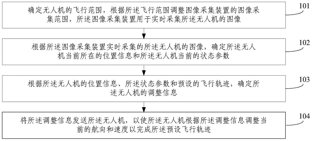
[0047] figure 1 A schematic flow chart of a method for spatial navigation of an unmanned aerial vehicle provided by an embodiment of the present invention, such as figure 1 As shown, the UAV space navigation method of this embodiment is as follows.

[0048] 101. Determine the flight range of the UAV, and adjust the image acquisition range of the image acquisition device according to the flight range, and the image acquisition device is used to collect images of the UAV in real time.

[0049] It can be understood that before the flight of the UAV is determined, the flying working range of the UAV, ie, the flight range, needs to be calibrated so as to determine the video a...


PUM


Abstract

The invention provides an unmanned aerial vehicle space navigation method, an unmanned aerial vehicle control system and an unmanned aerial vehicle control device. The unmanned aerial vehicle space navigation method includes the first step of determining the flight range of an unmanned aerial vehicle and adjusting the image acquisition range of an image acquisition device according to the flight range, wherein the image acquisition device is used for collecting images of the unmanned aerial vehicle in real time, the second step of determining information of the position where the unmanned aerial vehicle is located currently and parameters of the current state of the unmanned aerial vehicle according to the images, collected by the image acquisition device in real time, of the unmanned aerial vehicle, the third step of determining adjustment information of the unmanned aerial vehicle according to the position information, the state parameters and a preset flight track of the unmanned aerial vehicle, and the fourth step of transmitting the adjustment information to the unmanned aerial vehicle so that the unmanned aerial vehicle can adjust the current course and speed according to the adjustment information to complete the preset flight track. Through the unmanned aerial vehicle space navigation method, the flight state of the unmanned aerial vehicle can be accurately mastered indoors or outdoors, and intelligent flight of the unmanned aerial vehicle is achieved.

Description

technical field [0001] The present invention relates to navigation technology, in particular to a space navigation method for unmanned aerial vehicles, an unmanned aerial vehicle control system and a control device. Background technique [0002] The navigation equipment of the UAV in the prior art may include: a manual remote control device, a sensor navigation device including an airborne camera, and an airborne Global Positioning System (Global Positioning System, GPS) navigator, etc. [0003] However, the manual remote control device consumes manpower, and determining the flight state of the drone by human eyes cannot make the drone work continuously for a long time, and the drone cannot be precisely controlled, thereby failing to expand the application range of the drone. [0004] The sensor navigation device including the airborne camera is easy to increase the load of the UAV, resulting in a short continuous working time of the UAV; in addition, the sensor navigation d...

Claims


Application Information

Patent Timeline
Patent Type & Authority Applications(China)
IPC IPC(8): G05D1/10
Inventor 孙明陈方平王巧李晓马佳瑶刘云玲
Owner CHINA AGRI UNIV
Why Eureka
Try Eureka