

Direct ray tracking algorithm for geological radar chromatography detecting
A geological radar and tracking algorithm technology, which is applied in geophysical surveying, measuring devices, and gravitational field measurement, can solve problems such as low efficiency, long calculation time, and large storage capacity of ray tracing algorithms, so as to save storage space and reduce calculations. Time and memory requirements, the effect of simple algorithm steps
- Summary
- Abstract
- Description
- Claims
- Application Information
AI Technical Summary
Problems solved by technology
Method used
Image

Examples
Embodiment Construction
[0035] The present invention will be further described below in conjunction with accompanying drawing.
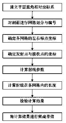
[0036] figure 1 It is a flow chart of the ray tracing algorithm of the geological radar tomography detection of the embodiment of the present invention, which specifically includes the following steps:
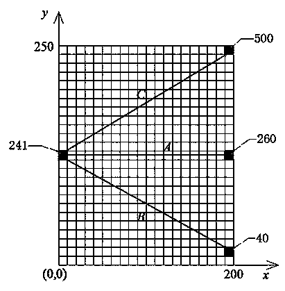
[0037] S1. Establish a plane Cartesian relative coordinate system: such as figure 2 As shown in , all the profiles detected by the ground radar are placed in the first quadrant of the coordinate system, where the tomographic detection direction is parallel to the x-axis, and the survey line direction is parallel to the y-axis; the origin of the coordinate axes is at the apex of the profile; the vertical distance of the tomographic detection is 200 meters, and the length of the survey line is 250 meters, then the coordinates of the four endpoints of the profile are (0, 0), (200, 0), (0, 250), (200, 250);
[0038] S2. Carry out grid division and numbering on the profile: ...
PUM
 Abstract
Description
Claims
Application Information