Subdivision, query and dynamic display method oriented to remote sensing data content

A technology of remote sensing data and query method, which is applied in the direction of electronic digital data processing, geographic information database, structured data retrieval, etc., and can solve the problems of remote sensing data cataloging such as lack of internal area attribute information, image redundancy, and data transmission pressure. Achieve the effect of improving query browsing efficiency, improving query efficiency, and reducing pressure

Inactive Publication Date: 2014-11-26
PEKING UNIV
View PDF5 Cites 13 Cited by
  • Summary
  • Abstract
  • Description
  • Claims
  • Application Information

AI Technical Summary

Problems solved by technology

With such a complicated and cumbersome query process, it takes at least a few days to complete the above-mentioned image request from Beijing to Shenzhen, and the images transmitted to users often have great redundancy, and their coverage greatly exceeds Users care about the area, causing great pressure on data transmission, seriously affecting query and utilization efficiency, making the current remote sensing data query methods unable to effectively provide solutions in the face of similar problems
[0007] Therefore, it is diff

Method used


Image

  • Subdivision, query and dynamic display method oriented to remote sensing data content
  • Subdivision, query and dynamic display method oriented to remote sensing data content
  • Subdivision, query and dynamic display method oriented to remote sensing data content

Examples


Embodiment 1

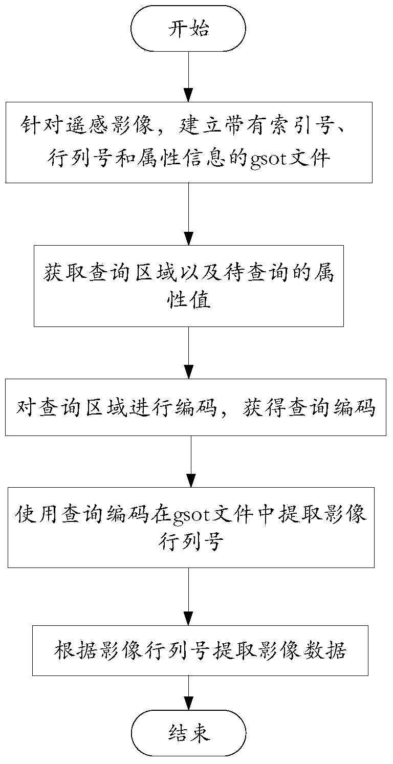
[0062] This embodiment is a remote sensing data content query method based on earth subdivision, such as figure 1 As shown, the method includes the following steps:

[0063] Step 1. For the remote sensing data, use the subdivision hierarchy set in the GeoSOT subdivision and coding scheme to subdivide the remote sensing data and create a subdivision index gsot file; The GeoSOT code of the subdivision patch is used as the index number, the position information of the image data in the subdivision patch in the remote sensing data, and the attributes of the image data are correspondingly stored in the subdivision index gsot file.

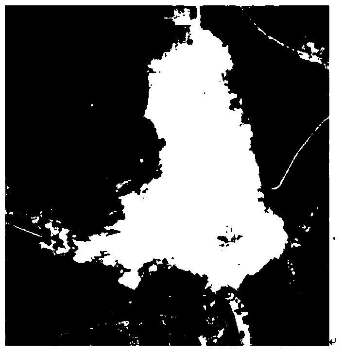
[0064] like figure 2 Shown is a remote sensing image processed in this embodiment. The gsot file created in this step can record various attribute types of the remote sensing image. For example, an attribute column dcloud in this embodiment records the cloud in the grid Coverage information, record the cloudless and cloudy information in a grid with ...

Embodiment 3

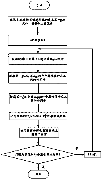
[0087] With respect to the earth subdivision-based remote sensing data content query method provided in Embodiment 1 above, this method can be adapted to dynamically display remote sensing data after improvement. Therefore, this embodiment provides a method for dynamically displaying remote sensing data indirectly using the above query method. The method flow is as follows Image 6 shown, including the following steps:

[0088] Step 1. For the geographical area to be displayed, the remote sensing image at time t is P t , to establish P t The dissection index gsot file W t , and P t The above figure shows;

[0089] Split index gsot file W t It adopts the subdivision level A to P in the GeoSOT subdivision and coding scheme t Obtained by subdivision, where W t The GeoSOT code of each subdivision surface is stored in the index number, and the image data in the subdivision surface is in P t The location information in and the attributes of the image data; the specific W t ...


PUM


Abstract

The invention discloses a subdivision, query and dynamic display method oriented to remote sensing data content. The method particularly includes the steps that remote sensing data are subdivided through a set subdivision level, and a gsot file is established; a GeoSOT code of each subdivision patch obtained after subdivision serves as an index number, and position information of image data in the subdivision patch in the remote sensing data and the attribute content of the image data are correspondingly stored in the gsot file; a query region and an attribute value to be queried are acquired, and a query patch and a query code corresponding to the query region are acquired through subdivision; when one index number and one query code are consistently matched from left to right, the length of the index number is larger than the query code, and meanwhile the attribute value corresponding to the index number is equal to the attribute value to be queried, image data corresponding to the index number are extracted. Meanwhile, dynamic display of the remote sensing data based on attribute information is conducted through the query method.

Description

technical field [0001] The invention belongs to the technical field of geospatial information and remote sensing data organization and management, and specifically relates to a remote sensing data content query method and a dynamic display method based on earth subdivision. Background technique [0002] Remote sensing technology provides a large amount of precious image data for humans to study the earth. In order to make full and effective use of these data and realize the efficient sharing and release of massive remote sensing data, it is necessary to establish a reasonable data query mechanism for users of remote sensing data. remote sensing data. [0003] At present, the browsing query method is the most important query method in the remote sensing data application service system. Its main function is to provide various users with an effective means of querying and retrieving cataloged and archived remote sensing data and product data at all levels. It provides a variet...

Claims


Application Information

Patent Timeline
IPC IPC(8): G06F17/30
CPCG06F16/29
Inventor 程承旗陈波陈东
Owner PEKING UNIV
Why Eureka
Try Eureka