Multi-tool collaborative three-dimensional geological modeling method and system for multi-source data

A technology of 3D geology and multi-source data, applied in 3D modeling, image data processing, instruments, etc., can solve problems such as poor modeling effect, low work efficiency, and limited data sources used by model types, and achieve modeling accuracy And the effect of fast speed and high work efficiency

Inactive Publication Date: 2014-12-24
武汉地大信息工程股份有限公司
View PDF5 Cites 14 Cited by
  • Summary
  • Abstract
  • Description
  • Claims
  • Application Information

AI Technical Summary

Problems solved by technology

[0005] However, due to the complexity and diversity of geological conditions, and the limitations of modeling software in terms of modeling methods and functions (for example, C Tech software has advantages in building fine stratigraphic models, but cannot build ore body models, for strata and In the area where the ore body exists at the same time, the complete geological model of the area cannot be constructed only by using C Tech software), and the user needs to select the corresponding software to complete the 3D modeling according to different geological conditions. The process of selecting software and modeling process are relatively comp

Method used


Image

  • Multi-tool collaborative three-dimensional geological modeling method and system for multi-source data
  • Multi-tool collaborative three-dimensional geological modeling method and system for multi-source data

Examples


Embodiment Construction

[0036] The present invention will be described in further detail below in conjunction with the accompanying drawings and embodiments.

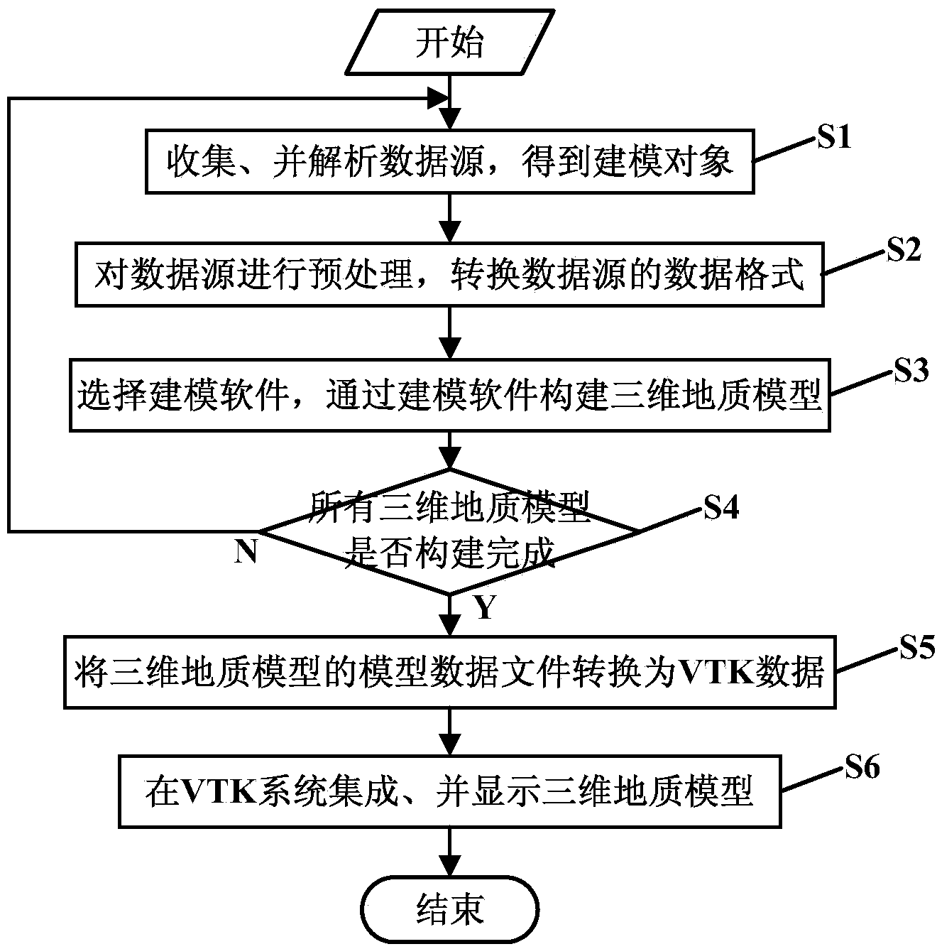
[0037] see figure 2 As shown, the multi-tool collaborative three-dimensional geological modeling method for multi-source data in the embodiment of the present invention includes the following steps:

[0038] S1: Collect geological data sources that need to be modeled. Data sources include geological plans, borehole data, measured profiles (or graph-cut profiles), geophysical interpretation data (or geochemical interpretation data), remote sensing data, and topographic maps and DEM (Digital Elevation Model, digital elevation model) data, etc. Analyze the data source to obtain the modeling object of the current geological region.

[0039] S2: Perform preprocessing on the data source (error checking, coordinate correction, etc.), and convert the data format of the preprocessed data source into a data format that can be read by the modeling sof...


PUM


Abstract

The invention discloses a multi-tool collaborative three-dimensional geological modeling method and system for multi-source data, and relates to the field of three-dimensional geological modeling in geological survey and exploration. The method comprises the steps that data sources of geology needing modeling are collected, the data sources are analyzed, and a modeling object of the current geological area is obtained; the data format of the data sources is converted into the data format capable of being read by modeling software; the modeling software is selected according to the current modeling object, the modeling software builds three-dimensional geological models according to the data sources corresponding to the current modeling object; the model data files of all the three-dimensional geological models are converted into VTK data capable of being read by an open resource freeware VTK system; all the three-dimensional geological models are integrated and displayed in the VTK system. According to the multi-tool collaborative three-dimensional geological modeling method and system for the multi-source data, the modeling precision and speed are high, working efficiency is high, a user can check all the three-dimensional geological models in the VTK system, and the user can use the multi-tool collaborative three-dimensional geological modeling method and system conveniently.

Description

technical field [0001] The invention relates to the field of three-dimensional geological modeling in geological survey and exploration, in particular to a multi-tool collaborative three-dimensional geological modeling method and system for multi-source data. Background technique [0002] Three-dimensional modeling of geological objects is required in geological survey and exploration. Due to the different ages and reasons for the formation of different geological bodies, different geological bodies have extremely complex topological relationships in space; especially the appearance of immersion bodies, folds and fault dislocations makes geological bodies more diverse in shape. transsexual. In order to make the different types of geological body models better reflect their actual shape, they must be classified and modeled using different methods. Geological bodies can be divided into layered entities, massive entities, faults and folds according to their shape. At present...

Claims


Application Information

Patent Timeline
IPC IPC(8): G06T17/05
Inventor 马维峰
Owner 武汉地大信息工程股份有限公司
Why Eureka
Try Eureka