
Method and device for eliminating distance measuring ambiguity of high repetition frequency airborne laser radar system

An airborne lidar, ambiguous technology, applied in measurement devices, radio wave measurement systems, electromagnetic wave re-radiation and other directions, can solve the problems of inability to judge echo signals, increase system costs, and return time lag of echo signals.

Active Publication Date: 2015-01-21
RES INST OF FOREST RESOURCE INFORMATION TECHN CHINESE ACADEMY OF FORESTRY
View PDF4 Cites 8 Cited by
  • Summary
  • Abstract
  • Description
  • Claims
  • Application Information

AI Technical Summary

Problems solved by technology

[0009] With the development of airborne LiDAR hardware technology, the repetition frequency of laser emission is increased to f max Above, there will be ambiguity in laser ranging: that is, the return time of the echo signal caused by the previous transmission pulse lags behind the transmission time of the next transmission pulse, so it is impossible to judge which transmission pulse the echo signal is caused by. The ambiguous ranging result is called ambiguous distance, that is, ranging ambiguity occurs
[0010] At present, the existing methods for eliminating ambiguity in distance measurement all require adaptive modification or addition of special hardware modules in the hardware system, thereby increasing the system cost

Method used


Image

  • Method and device for eliminating distance measuring ambiguity of high repetition frequency airborne laser radar system
  • Method and device for eliminating distance measuring ambiguity of high repetition frequency airborne laser radar system
  • Method and device for eliminating distance measuring ambiguity of high repetition frequency airborne laser radar system

Examples


Embodiment 1

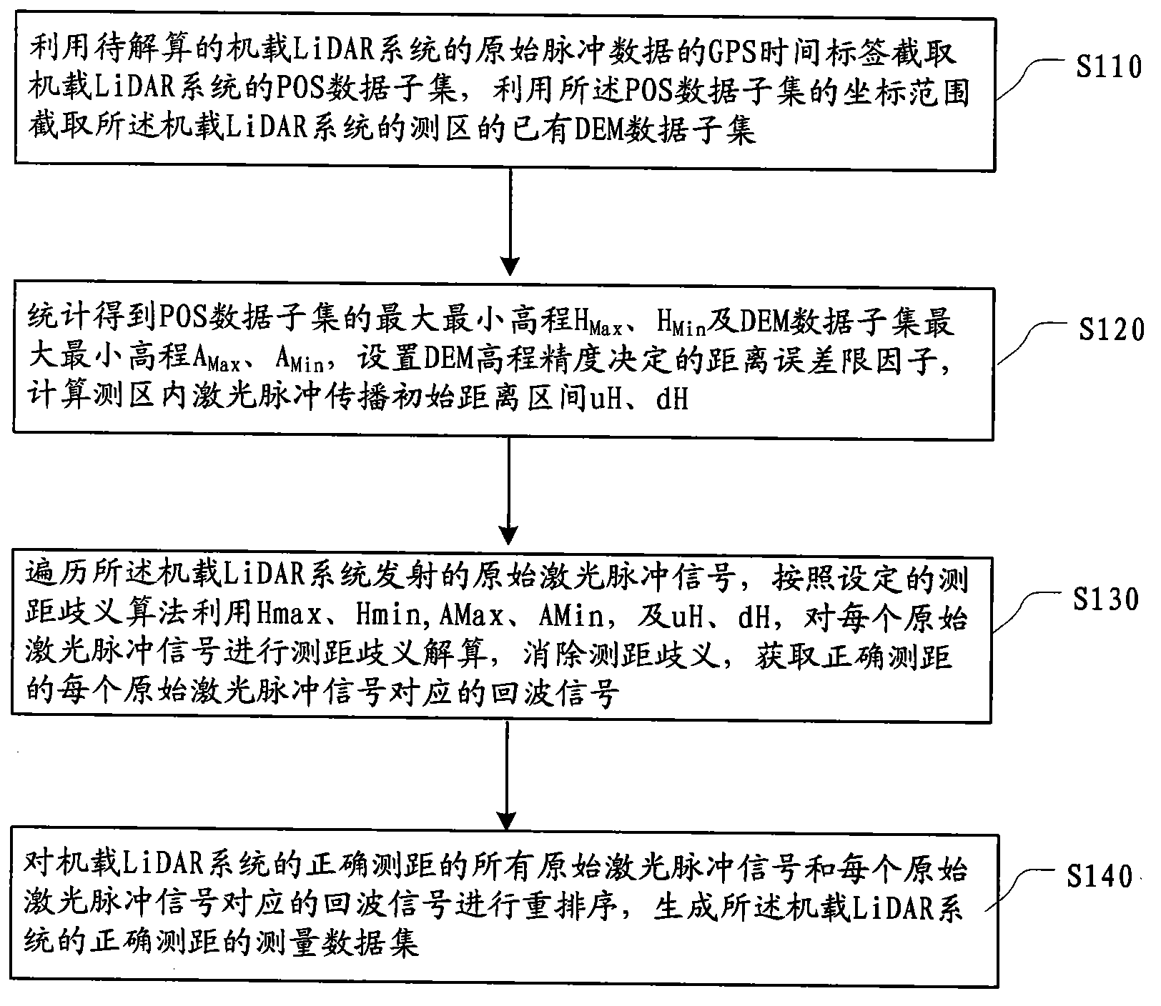
[0069] According to the IEEE standard RADAR definition, Second Time Around echoes refer to echo signals received within a time range exceeding one PRI but less than the PRI. Similarly, Multiple Time Around (MTA) echo means that the echo signal is received after passing through several PRIs. The initial practical application of the MTA concept appeared in the ground RADAR system, which uses the Multiple PRF (Multiple Pulse Repetition Frequency) transmission method, and uses the Chinese remainder theorem or shift register technology in the real-time signal processor and so on to calculate the unambiguous ranging distance of the target.

[0070] POS (Position and Orientation System) system, also known as IMU / DGPS system, consists of dynamic differential GPS (DGPS), inertial measurement unit (IMU), main control computer system (PCS) and corresponding post-processing software. It is composed of parts, which can measure its position and attitude in real time during the imaging proc...

Embodiment 2

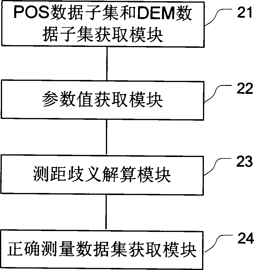
[0101] This embodiment provides a device for eliminating the ranging ambiguity of the high-repetition airborne LiDAR system, and its specific implementation structure is as follows figure 2 As shown, it can specifically include the following modules:

[0102] POS data subset and DEM data subset acquisition module 21, for using the original pulse data of the airborne LiDAR system, select the POS data subset corresponding to the time range and the DEM data corresponding to the spatial range of the survey area of ​​the airborne LiDAR system Subset;

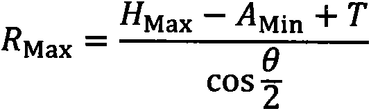
[0103] The parameter value acquisition module 22 is used to obtain the maximum and minimum elevation of the POS data subset, the maximum and minimum elevation of the DEM data subset, set the distance error limit factor of the DEM data subset, and calculate the The initial distance interval of laser pulse propagation in the survey area and the upper and lower tolerance thresholds of the spatial distribution of ground objects;

[01...


PUM


Abstract

The embodiment of the invention provides a method and device for eliminating the distance measuring ambiguity of a high repetition frequency airborne laser radar (LiDAR) system. The method mainly includes the steps that original pulse data of the airborne LiDAR system are used for selecting a POS data subset in the corresponding time range and a DEM data subset in the corresponding spatial range of a measuring area of the airborne LiDAR system; original laser pulse signals transmitted by the airborne LiDAR system are traversed, the POS data subset and the DEM data subset are used for carrying out distance measuring ambiguity resolving on all the original laser pulse signals according to a set the distance measuring ambiguity algorithm, and echo signals corresponding to all the original laser pulse signals with correct distance measuring are obtained. Based on existing DEM data and POS data, fuzzy distance resolving is directly carried out on the original pulse data of the airborne LiDAR system to eliminate the distance measuring ambiguity, the echo signals corresponding to all the original laser pulse signals with correct distance measuring are obtained, and under the condition that no transformation is carried out on a hardware system, the problem of the distance measuring ambiguity, caused by high repetition frequency, of an existing airborne LiDAR system can be effectively solved.

Description

technical field [0001] The present invention relates to the technical field of laser radar, in particular to a method and device for eliminating ambiguity in distance measurement of high repetition frequency airborne LiDAR (Light Detection And Ranging, laser radar system). Background technique [0002] The airborne LiDAR system is a remote sensing technology that emits laser pulses through active sensors and detects the returned laser pulse signals to measure the distance between the sensor and the target and the reflection characteristics of the target. The airborne LiDAR system emits laser pulses to the ground at a certain PRR (Pulse Repetition Rate). The higher the LiDAR repetition rate, the higher the spatial sampling rate of ground objects, thus showing better three-dimensional structure description capabilities. [0003] When the airborne LiDAR system is running, it emits laser pulse signals and receives the echoes formed by the reflection of ground objects, samples an...

Claims


Application Information

Patent Timeline
IPC IPC(8): G01S7/487
CPCG01S7/4876G01S17/10
Inventor 卢昊庞勇
Owner RES INST OF FOREST RESOURCE INFORMATION TECHN CHINESE ACADEMY OF FORESTRY
Learn More