Method for describing geographic information of rail transit line

A technology of rail transit and geographic information, which is applied in the field of rail transit, can solve problems such as the integrity of geographic information data, guarantee defect safety, etc., and achieve the effect of deleting abnormalities and ensuring integrity

Active Publication Date: 2015-03-04
TRAFFIC CONTROL TECH CO LTD
View PDF3 Cites 10 Cited by
  • Summary
  • Abstract
  • Description
  • Claims
  • Application Information

AI Technical Summary

Problems solved by technology

[0005] In order to solve the application in the existing CBTC system the G Potential Se

Method used


Image

  • Method for describing geographic information of rail transit line
  • Method for describing geographic information of rail transit line
  • Method for describing geographic information of rail transit line

Examples


Embodiment 1

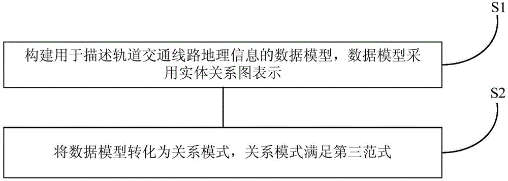
[0037] This embodiment provides a method for describing geographical information of rail transit lines, and the step flow chart is as follows figure 1 shown, including the following steps:

[0038] Step S1, constructing a data model for describing geographical information of rail transit lines, the data model is represented by an entity-relationship diagram (Entity-Relationship Diagram, E-R diagram for short).

[0039] Step S2, converting the data model into a relational schema, where the relational schema satisfies the third normal form.

[0040] The third normal form indicates that each non-primary key attribute is atomic and completely dependent on the primary key, and there is no transfer function dependence of non-primary key attributes on the primary key.

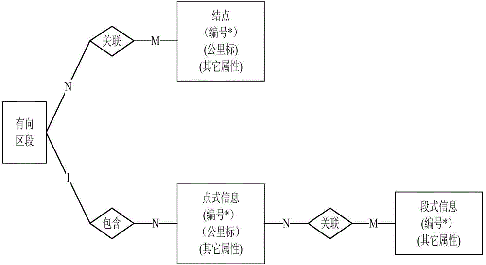
[0041] Optionally, the data model used to describe the geographical information of rail transit lines constructed in step S1 includes:

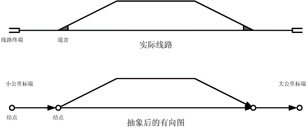
[0042] The rail transit line is abstracted into a directed graph, in which th...


PUM


Abstract

The invention discloses a method for describing geographic information of a rail transit line. The method comprises the steps of constructing a data model for describing the geographic information of the rail transit line, wherein the data model is represented by an entity relationship diagram; converting the data model into a relation mode, wherein the relation mode meets the third normal form. According to the describing method provided by the invention, by the application of the relation data theory, the geographic information of the rail transit line is molded, so that the data model of a geographic information system is obtained; the data model is converted into the relation mode, so that the completeness of data is defined according to a completeness rule of the relation mode; the relation mode meeting the third normal form is obtained by applying the relation mode. The method is used for eliminating redundancy in the relation mode, so that interpolation, modification and deletion abnormities of the data can be avoided, and the completeness of the data is further guaranteed.

Description

technical field [0001] The invention relates to the technical field of rail transit, in particular to a method for describing geographical information of rail transit lines. Background technique [0002] In recent years, in the field of rail transit operation control systems, the Communication Based Train Control System (CBTC system for short) has developed rapidly. In the CBTC system, the calculation of the movement authority (MA) usually depends on Geographic Information System (GIS for short). The GIS applied to the CBTC system usually includes geographical information such as line topology information, trackside equipment coordinate information, line permanent speed limit, temporary speed limit and slope. [0003] At present, in GIS, usually based on topology theory, rail transit lines are abstracted into undirected or directed graphs, and the bifurcation points on the line (such as switch centers or points) and section separation equipment (such as axle counters or ins...

Claims


Application Information

Patent Timeline
IPC IPC(8): B61L27/00B61L25/06
Inventor 殷江宁周军利
Owner TRAFFIC CONTROL TECH CO LTD
Why Eureka
Try Eureka